Thursday, May 31, 2012

Until recently, I had never heard of Virgin Falls. A friend sent me a link suggesting I take a look at it, and their hunch was right, I fell in love with what I saw. When I began planning a hiking vacation, I knew that it would have to include a hike to Virgin Falls. Not only do you get to see a magnificent 110ft waterfall but you hike past three other waterfalls, each with their own remarkable beauty.
uh-oh!

On day two of our stay in Sparta, TN, we started early for a Sunday hike to Virgin Falls. By 9am we were to the parking area of the Virgin Falls Pocket Wilderness, I was mildly discouraged to see the parking lot nearly full with around 14 cars ahead of us. I had read it was a popular camping destination so I suspected we may pass some overnight hikers leaving on our way in. Steve was in charge of carrying the backpack with our food, water, and first-aid gear and I had my camera and more water. The hike is an 8 mile round trip hike that descends the entire trail until reaching the main Falls. A sign at the trail head cautions you of the distance and the fact that recently people have got lost along the way. I found this to be exciting and added to the thrill of the hike.
cliffside trail
clear swimming hole

The first mile or so of the hike is relatively flat with only a mild descent, each step of easy hiking was a welcome one considering our first day had us on our feet for over 10 miles of tough hiking. After just over a mile, we picked up a stream that was nearly completely dry, as we climbed down the hill where Big Branch Falls was supposed to be cascading over a 25ft drop we were greeted with a rock wall. I wasn't surprised nor extremely disappointed because I knew it had a low watershed. We continued on another mile and really started to descend steeply picking up another stream with significantly more water, as we came around some boulders I stepped in a yellow jackets nest and got a few stings on the leg, I hurried away and down the hill catching the first glimpse of Big Laurel Falls. Although it was barely flowing as well, the massive cave behind it had my attention and I was impressed! Once we caught the creek bed we hiked back to the cave and explored it thoroughly, it was as wide as a football field and nearly as deep. The amazing thing here is that the falls drain backwards underneath itself and drops into a cave below the back of the cave we were standing in. Steve had brought a flashlight and we could see a long way into the small opening the water was draining in and the soft ground beneath my feet made me nervous we could break through at any time. The flash on my camera was not powerful enough to fire in the dark cave and I was forced to snap photos with the aid of his flashlight. I soaked my hat under the falls to cool my head, it was only 1030 and the temperature had to be approaching 90 degrees. Back on the trail the climb leveled slightly and we met several forks in the path that I was unaware of, I knew the main trail was marked with white blazes so we continued on following the small paint spots sporadically placed on the trees. In about another hour we arrived at a four wheeler path with a sign to the left for the Caney Fork River and the right wasn't marked but I knew the falls wasn't on the river. We hiked steadily up hill for about twenty minutes and suddenly I could see Virgin Falls! I was glad to see it but puzzled that I had missed the Sheep Cave and the falls there. Steve could have cared less, something about the falls makes you feel like you have stepped through time, I felt like we were the first person to lay eyes on it. Surprisingly we were the only people there also, we had passed a few people heading out and not passed any other hikers so I'm not sure where the other hikers were. The falls had a nice flow and they empty into a large bowl shaped crater with surprising steepness. Steve and I climbed down to the base and the mist was a welcome break from the smothering heat of the day. He climbed through the falls standing behind them, he suddenly began laughing and frantically waving for me to join him. I put up my gear and took my wallet out of my pocket to keep it dry when I crossed under the water. As I joined Steve on a narrow ledge, I looked down and into the deepest and darkest drop I have ever seen! The falls drain behind itself and have caused a massive cave to form over the years of erosion. I couldn't see the bottom only hear water distantly hitting below. I was really uncomfortable standing on a slick rock so close to certain death and headed back to the safety of the hill side. Steve soon joined me and we decided the hike was well worth it.
Approaching Big Laurel Falls and cave
closing in on the cave
dwarfed by the massive cave
inside Big Laurel Cave
Big Laurel Falls

Virgin Falls is indeed worth the 8 mile round trip hike if you are a waterfall lover. The hike itself is beautiful following along large rock bluffs, clear blue swimming holes, and distant mountain views. On our hike out I found the first tick attached to my leg of the season, I picked him off and was no worse for the wear. Upon arriving back at Big Laurel Falls we took lunch and rested, the next mile of trail was straight up and through the dreaded yellow jackets. Thankfully, we made it safely through and actually finished the last mile of the hike faster than we completed the first. We said goodbye to Sparta and it's wealth of waterfalls and traveled back to Gatlinburg, TN for some hiking in the Smokies but that would have to wait until day 3, my legs made that decision for me. Until next time...Happy Trails!
Virgin Falls
SUCCESS!

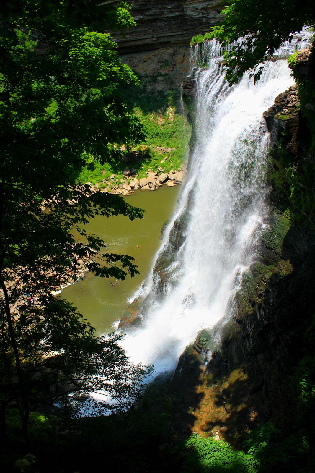
In a previous blog post, I talked about a visit to the Thompson River area of North Carolina and the falls located on the river, that day was to be a coronation of sorts, having successfully viewed eight waterfalls in one day and seeing the best one last. Instead, Kip and I found ourselves lost twice, out of water, out of food, and narrowly escaping serious danger, staggering out of the woods as the sun vanished behind the mountains.
High Falls on Thompson, from a visit in early April

A valuable lesson was learned that day, and yesterday Steve and I packed more carefully and set out for Cashiers, North Carolina in search of the Big Falls on the Thompson River. I packed twice as many supplies this time, fully prepared for what could go wrong. All descriptions online had labeled it as a strenuous hike with the descent to the river itself being challenging and tiring having to use ropes to scale down cliff sides!

This is the 2nd falls on Thompson River, I found this one on my 1st visit, I was devastated I didn't make it to Big Falls

From the parking area along Brewer Road off hwy 281, we followed an old logging grade up the hill and into the wilderness. The trail is overgrown and many downed trees make it tough going at times. The trail forks on more than one occasion and if not for my previous failures I would still be unsure which way to go. The occasional pink flagging tape is the only sign of direction but be careful, they can lead you the wrong way as well. Several falls are heard along the trail but we saved our energy for making it to Big Falls, I was determined to make it this time! After almost three miles you come to a pile of rocks on the main trail and some pink flagging tape following a steep trail toward the river and a roaring waterfall, this is NOT THE RIGHT TRAIL! It will take you to a nice 80ft falls known as the Second Falls on Thompson. Kip and I went down the is trail the first visit and were too exhausted to follow the main trail the extra 30 minutes to the Big Falls trail head. Instead of going to Second Falls continue down the main trail, it is still overgrown and eventually you will not hear the falls or river at all (although briefly) the river sounds faint again, keep looking to the left and there will be a small path to the left marked with flag tape. The trail appears tame at first casually winding down toward the river. Our hiking experience made this an easy go for us but it is slightly steep. Suddenly the trail turns steep and gnarly, luckily there are ropes already tied off to descend the cliffs, there are three separate sections like this. Eventually you find yourself atop a 20ft high boulder and have to wiggle your way down through a crack in the rock! By this point the river can be seen through the trees and parts of Big Falls are visible. You emerge just below the falls, and have to cross the river, it's not too hard there are huge boulders everywhere and we made it with ease. We followed the right side of the river upstream but a massive boulder blocks a good view of  the falls.
Steve sitting by Big Falls
at last! a full view!
the swimming hole at the base
the river hidden by the many boulders

I had to take my shoes off to climb the boulder it was so steep (it's twice the size of my house) once I made it to the top and was so relieved to see the whole falls in all it's beauty. It's a 150ft waterfall with multilevel cascades and a steep slide at the bottom into a deep pool! We were exhausted from the climb down and honestly I was wondering how I was going to get out of that gorge, but after a snack and a Gatorade we got our wind and was exploring and taking pictures. Steve was the first to take the Big Falls slide, he climbed over while I waited to film his trip and he slid down the rock with surprising speed. He rejoined me atop the boulder and I put my camera up and took the slide myself. The water felt great and was really deep, it was somewhat choppy and probably too dangerous for kids. After all the sweat I had lost it felt good just to lay back and let the water beat against my tired body. We slide more times than I could count and each time I was laughing the whole way. It's a real shame it's so isolated, but if it were easy to get to, there would be a waiting line to ride the water slide.
I knew these ugly toes would eventually come in handy!
Steve taking the plunge!
from on top of the house sized boulder

Eventually we packed up and with heavy dread began the steep climb out. We rested four times while climbing out and it still only took 30 minutes to meet the trail head, but even then you have a three and a half mile hike uphill to the safety of the parking area. As we were hiking out we encountered a young couple heading in and visited with them briefly, they had ran in, I was stunned at their physical condition. After another mile we met an older couple who had got lost a few times, I took his map and marked the correct way and sent them on their way, I told them not to try the Big Falls trail if they were already tired too. I can't tell you how happy I was to see the truck. Surprisingly, I felt good, a sign that all my hiking has paid off with better conditioning and stamina.
Upper half of falls
love this one, slightly cuts off the slide.
heading out, four miles to go!

I would have to rate the Thompson River area as some of the finest of all the falls I've visited. Sadly, it doesn't receive the recognition it deserves because it's sandwiched between Gorge's State Park and Whitewater Falls (over 400ft) while both of those parks are highly developed and visited frequently, Thompson is a road side pull off with no facilities or even signs. If you are a waterfall junkie like me though, you would be cheating yourself if you didn't put this on your list of must see waterfalls! Until next time...happy trails!

Tuesday, May 29, 2012

Sometimes it seems we make big plans and dream about doing things in life but they never materialize because of one thing or another. For the past few years I've talked to my friends about doing a hiking vacation but something always delayed it or canceled it...until this year! My friend Steve and I used to work together but now that we work at separate locations it's easier to schedule our vacations together and so for the past month or so I've studied maps of Tennessee looking for the perfect centralized location for the most bang for our buck.

My attention was quickly drawn to the Cookeville and Crossville area in middle Tennessee. The area appears flat to the passer by but you are actually high in elevation atop the Cumberland Plateau. The area features some really unusual geological formations and some of the biggest falls in all of Tennessee. Some of the creeks flow underground only reappearing briefly flowing from a cave before emptying into yet another cave. We highlighted some areas on the map and decided Sparta, TN was the best place to stay so that all falls we visited would only be about a 30 minute drive.

Saturday morning we left Gray, TN about 9am and by 1130am we arrived in the town of Ozone just off the Crab Orchard exit. Ozone is home to Ozone falls, it's a beautiful 90ft drop in a cathedral setting. The plunge pool is a deep green water which drains underground and reemerges a couple hundred yards downstream. I had visited here once and couldn't resist visiting since it was only five minutes off the interstate. Here's a few pictures of Ozone falls.
don't slip here.
Ozone Falls
water draining underground
From Ozone Falls we headed toward Crossville only 20 minutes down the road, I had read that it was home to the world's largest tree house, and indeed, a few miles off the exit we arrived at a 10 story high tree house absolutely crawling with people. Unfortunately, I didn't take my camera in just my trusty iPhone. The tree house is private property built by a preacher, taking him over 17 years to complete. The religious nature of this stop caused me to caution Steve about his colorful language. We both were like overgrown children quickly climbing all 10 stories and explored all the various rooms discovering a basketball court about five stories up and shooting a few hoops, yes the tree house is that large! It was a nice place and I recommend visiting if your ever in the area.

Our next stop took us just outside Cookeville, TN to Burgess Falls State Park. Burgess Falls was a little out of our immediate driving range but I felt like it might be a good one. The park was really nice with plenty of picnic tables and playgrounds for the children. The thing that stuck out the most to me was that it was full of park rangers all dressed similar to that of Dudley Do Right. (This comes into play later) The hike from the trail head follows the river downstream passing  several nice falls, it's only about 20 minutes before you arrive at the main falls and the observation platform high above the river. People swimming in the pool below the falls looked like ants and a few people were jumping from about 20 feet up when a park ranger with a megaphone interrupted my picture taking screaming at them to "not climb on the falls" Steve laughed it off and said, "let's go climb the falls" and we were off to the base. The climb down the side of the cliff takes you through a caged stairway along a cliff, reminding me of Jurassic Park. Eventually you have to climb down the bank as best you can to reach the base. The boulders along it's shore were surprisingly sharp and unsteady, and it smelled like rotten fish. The falls however, were spectacular, at 136ft high and an entire rivers flow spilling over them, I was in awe. Steve took the time to explore and disappeared over boulders only reappearing when he discovered a trapped duckling and brought it back to where I was situated on a boulder near the shoreline. He threw it in the pool and I have never seen a creature move so fast through water! It crossed the large pool at the base with ease and reunited with it's siblings on the opposite shore within seconds. Here's a few pictures of the Burgess Falls area.
middle falls at Burgess, 80ft high!
beautiful rainbow at Burgess Falls
standing at the edge
side shot from stairs leading to base.
Me at Burgess Falls
After playing at the falls and saving our duck friend, we started the strenuous climb out. Just past halfway up the trail two rangers approached us quickly from the top with their rescue gear out. The first ranger which was the younger of the two asked if anyone was hurt at the bottom and we said we didn't see anyone, the second older ranger was lagging behind and appeared to have caught a cramp, he asked us to help in the rescue by going upstream because he had hurt himself! We agreed but saw no one and eventually climbed out and was greeted by another ranger who told us we couldn't rest at the overlook and to keep moving that rescue vehicles were in route. The so called injured person was delivered by ambulance to their car and they drove past Steve and I as we huffed and puffed our way out to the truck.

The day was still young so we decided to knock out Fall Creek Falls while we had plenty of daylight left. Fall Creek Falls is the most popular waterfall in Tennessee and is visited by hundreds of thousands people yearly, so being a Saturday afternoon I knew picture taking would be difficult. The drive in feels like it takes an eternity and upon arriving at the park the signage doesn't give you clear directions where to park for ease of access. Steve and I parked at the furthest point away from the main falls and had to hike almost two miles to the overlook. I could tell there was a lot of people at the base but standing over such a massive drop and falls was more than I could resist, I had to go to the base. We went down the trail which was steep but well maintained and arrived at the falls within 15 minutes. It was covered up with people of Indian decent all splashing and playing in the water. Steve and I were the only Americans there! He leaned over and asked, "Is this the road to New Delhi?" a line from Indiana Jones. We took some photos and he even hiked over and washed his hair underneath the falls. The climb out was taxing and we stopped a few times resting and overlooking the massive gorge. We made it back to the truck starved and soaking wet from sweat and splashing around the falls but were satisfied with day one. The falls we had took in were beautiful and unique, it would be hard to top them, but we would try...to be continued.
Cane Creek Cascades, smothered with tourists.
swing bridge above Cane Creek
Fall Creek Falls
the base at Fall Creek.


Tuesday, May 15, 2012

In early February I took a trip deep into the woods of Erwin, TN to the Sampson Mountain Wilderness Area and the highly elusive Buckeye Falls. You would think it would be difficult to hide a 700ft waterfall, that's right 700ft, but the lack of trail and many twists and turns along the way leave more hikers empty handed than you would think. There was very limited information on the area and even fewer pictures. I think this drove my determination to go even more, so I enlisted my friend, Kip and we were off to the wilderness.
deep pool around 7ft along the creek
trail narrows or maybe I widen?
no trail
still no trail

The trail starts at the end of Clark's Creek Road and horseback riders have worn the trail which stays level for over two miles and with just a few creek crossings. I was surprised how easy it was and made the mistake of making fun of people who claimed it to be so difficult. The first two miles are indeed easy, the last two miles make you really doubt yourself very quickly. The trail narrows and large trees have fell over the trail and it follows steep ledges high above the creek and drops drastically to creek level and then rises sharply on the opposite side. The up and down can tire your legs quickly and navigating the brush becomes awful. Eventually the trail fades and your left with fighting your way up stream staying with the creek as best you can. At a little over 3.5m in a small creek enters from the left on the creek your hiking on. I noticed a worn piece of flagging tape here but no sign of trail so continued on and eventually arrived at a nice 10ft waterfall. Luckily I remembered reading if you reached this falls you had come to far. We turned and went back to the creek we had seen on the left which was now on the right. Unsure if we were heading the right direction we started up the steep stream just wading through it because of all the underbrush along the banks. Half way up the creek I could see a huge rock cliff face at the top of the hollow. Several downed trees had to be negotiated and after clearing them the stream turns to the right around a bend and Buckeye Falls becomes visible. I was so excited to see it although it doesn't have a huge watershed it towers above the valley but I still had at least half a mile of climbing to reach it's base.
incredible rock formations
10ft waterfall

Once we arrived at it's base I couldn't believe how steep the terrain was, I couldn't put my feet on the ground I had to stand on my toes! I would one day love to climb half way up the falls to a huge boulder but that's over 300ft of near vertical climbing! Kip and I marveled at the area and rested from the difficult hike. We vowed to return during a time of flooding to see a large amount of water coming off the falls, during dry weather the falls dry completely up. I wouldn't recommend trying this hike alone or unprepared. It's eight miles round trip and during the summer I'm sure chock full of snakes, spiders, and even bears. The area is known to have the second highest black bear population in all of Tennessee. If you do hit the trail, stay safe, have fun, and until next time...happy trails!
more trail troubles
that tiny dot is Kip climbing up the gorge
it's a tough climb
behold! Buckeye Falls!
heading out.