Earlier today I walked into a local outdoor supply store named Mahoneys to look at camp stoves when two employees frantically approached me. I first came into there lives back in October when I inquired about a sleeping bag for someone seven foot tall. I didn't know it, but since then they had spent time researching lesser known reaches of the internet and had came over to share with me their findings.
 |
| Om the off trail summit of Big Cataloochee Mountain, |
 |
| The start of the one way Balsam Mountain Road. |
Of course the first thing I thought of was my Smoky Mountain camping trip and the reason to need a sleeping bag in the first place. The camping trip was the brainchild of my college roommate, Ben, who had came up with it while I was telling him about some my earlier adventures to some remote Smoky summits, including Guyot. I told them there were a few that could be done in a day hike but I would prefer using a shelter as base camp and making the trip a two day affair. Ben didn't hesitate and immediately suggested booking a shelter sometime in the fall and "knocking them out." Being a grocery store manager the months of November and December are pretty much off limits for anything so we settled on the last few days of October sandwiched between inventory and the Halloween holiday.
 |
| Some open views looking back toward Maggie Valley. |
Unwittingly, we had picked the perfect time for a trip considering the one way Balsam Mountain Road closes at the end of October making our trip much longer and more difficult including several deep creek crossings on Gunter Fork. With our days picked we had to make sure we could get a shelter reservation but you aren't allowed to try to get one until 30 days prior to your stay, Ben called the first chance we had and we were the only two people booked for those days. I watched the weather closely and a warm October looked great with the exception of the days we had our trip planned with a cold front moving in with rain and even some snow. As the days grew closer the rain chance moved into earlier in the week but the bitter cold hoovered on our two day camping trip. Besides not owning a functional sleeping bag, I barely owned warm clothes, so I was really concerned.
 |
| I was excited to hit the trail even if it was gonna be freezing. |
 |
| Fall colors were nice on the way to Laurel Gap Shelter. |
When I settled into packing I stuffed a couple of emergency blankets into my bag along with some old sweatpants and a hoodie. I was sure to have my gloves and wool socks along with my toboggan. My poor sleeping bag was a 45 degree Academy Sports bag that came to just below my nipples. It was going to be a long night, but it was only ONE night.
 |
| Ben inspects a boardwalk through a muddy stretch of trail. |
 |
| Nearing the summit of Balsam High Top the forest has changed over to the tough evergreens that guard the summit. |
Ben and decided to meet along the Blue Ridge Parkway near Balsam Mountain Road and we would carpool from there. After checking out the condition of the one way gravel road to the trail head however, Ben decided he would just follow behind me instead. We arrived at the Pine Oak Gap trailhead in a sharp curve nearly full with only space for a few cars. My first thought was people would be illegally camping in our reserved shelter but as we hit the trail my mind focused on the gradual climb up and around Balsam High Top.
 |
| Inside the Laurel Gap Shelter...notice Ben's plush sleeping arrangement? |
 |
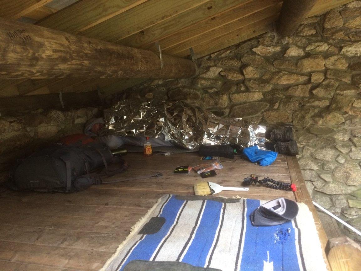
| Here is my set up. The liquor did not help. |
The hike was a celebration of sorts with it's completion it would give me over 900 mile for 2017 and it would scratch two more off trail summits from my list. The weather, although cold, was perfect for hiking, as long as you were moving, it felt great. Climbing Balsam Mountain isn't easy as the elevation gain begins immediately and doesn't relent until several miles later as you skirt by near it's summit. Ben was in a pleasant mood as we wound higher on the mountain and the forest changed to the rugged evergreens that top the highest peaks in the Smokies. Unfortunately for us, the trail would dip and rise several times before we would begin a steep descent into Laurel Gap. When we reached the gap we found the shelter to be empty and we unshouldered our packs for a look around. The shelter had a built in fireplace but it was chocked with trash from previous occupants. A water source was down a short trail and Ben found it to be flowing strongly. Things were looking up for us already, now all we had to do was gather some firewood. It was only 130pm and we had plenty of daylight but as you can imagine, finding firewood easily near a popular shelter can be a challenge. Another issue was the rain from earlier in the week had every single piece we found still damp with moisture.
 |
| The grassy open summit area of Big Cataloochee.. |
 |
| Despite what it looks like I'm not praying. I'm taking a picture of Ben. |
Ben and I split up and found some branches that had fell and hung up in the trees before hitting the ground and getting soaked. When we piled up put gatherings, they looked pitiful at best. I gave up on the wood search and went to pick out my spot in the shelter. I chose the upper platform near the corner, I'm not sure why but that was my spot. I unrolled my sleep mat and layed my bag on top. Just for giggles I crawled inside and stared up at the ceiling, it was obvious I wouldn't be sleeping. With plenty of daylight and a few minutes of rest, I set into studying my map and noticed we were really close to the summit of Big Cataloochee Mountain. I told Ben we should try to knock out the summit before dark making our next day a little easier with only Luftee Knob. With its close proximity to the shelter I also chose to leave my pack behind only taking some water and my cellphone.
 |
| Ben enjoying some jerky at the summit. |
 |
| Ben loved this burl. |
 |
| Ben decided I needed to be included in this prize discovery. |
I cheated before leaving for the trip and downloaded maps to my backcountry navigator app. It's ability to pick up literally anywhere was a definite help in making our decision to leave the trail to bushwhack up to the summit. The climb up Big Cataloochee was open forest with minimal downfall making for an easy trip. When we found the ridge we simply made our way to the highest point finding a few shards of tape from previous peak baggers and Ben fished his hammock from his pack to hang on the summit. I introduced Ben to hammocks at our eclipse camping trip and he went straight home and bought one for both him and his wife. I found a large moss covered fallen tree to lean back on and enjoy the cold but beautiful surroundings. Everything was coated in bright green moss and aside from the worn flagging tape there were no discernible signs of human interference. I could hear Ben humming now deeply snuggled into his hammock and the occasional shuffle of plastic as he dug in the bag of beef jerky I'd brought. I noticed down through the forest a large burl on the side of a tree, a closer inspection would reveal it to be the largest that I had ever seen. Ben was so impressed he had to take a few selfies with it before we headed out in search of dry firewood and some food for dinner. When we arrived back at camp we still had the place to ourselves and we had dragged a few large tree branches from the slopes of Cataloochee for firewood. Ben suggested we build the fire in the outdoor pit since the chimney seemed clogged inside the shelter. We gathered small sticks and built an opening to light the fire. Surprisingly to us both, we succeeded. The flame was nothing compared to the smoke generated by the damp wood but a small amount of heat could be felt. We sat around the fire talking about the eclipse trip and how much fun we had with so many firsts, including some that I can't share with my general audience. We laughed and relived the weekend and the sun began to go behind the ridges. No sooner did I tell Ben we wouldn't see anyone for the rest of the day, a female voice asked, "Are you guys staying the night?" I turned around from my log stump seat to see a curly headed girl with a full pack walking over to join us. She threw her pack on the bottom platform of the shelter and brought her food bag over by our small fire.
 |
| Back at camp, the fire rages. |
 |
| Ben worked up an appetite making that fire. |
 |
| Things were looking bleak. |
 |
| Liza shows up and saves the fire with a pot lid and some mad skills. |
I watched intently as she unpacked a jetboil and started cooking her supper on the small stove. My beef jerky and trail mix suddenly seemed inadequate. She told is she was on an eight day solo trip with this being her first night in the Smokies all the way from Massachusetts. As she ate her dinner she asked if that was the best we could do for a fire and came over fanning the flames with her cook pot lid stoking the fire to its best effort yet. I excused myself to search for more firewood and came back a hero after finally finding some significant amounts of dry wood. Ben and Liza were telling stories and we all enjoyed each other's company as darkness fell in the Smokies. The sky was clear and the moon hung directly over our shelter, the scene could have not been more beautiful. With the dry firewood, we extended a normal backpackers bed time and didn't retire to our sleeping bags until around 9:30. I gathered my charging gear and plugged in my phone and opened several hand warmers including a patch I stuck on my lower back. I stuck on my gloves and toboggan and unfurled my emergency blanket for my torso. At the time, I felt like it was all under control.
 |
| Morning two on the slopes of Luftee. |
 |
This was not a set up. I was resting and Ben wanted to take a picture of the summit cairn. |
Fast forward to 4am and both Liza and Ben were snoring in their zero bags while I had shivered and tossed and turned for hours. I couldn't get warm or comfortable and as the moon lit the outside of the shelter I could see that it was snowing. The wind at times would howl and I thought for sure the rough would blow off and they would find me like Jack Nicklson in the Shining frozen to the core. I took my hand warmers out of my gloves and tucked them against my face. I noticed the cold had killed my auxiliary battery power and cell phone only had a 50% charge. I turned the phone off completely to preserve it for our need for its map the following day. I thought about my bed at home and how warm it always was but then I thought of how many people spend every day on the streets without even a roof and in all weather. My resolve warmed me and when I opened my eyes again it was almost 7am. The ground was white in patches where the wind had kicked around the snow, I tried to quietly slip out of the shelter to visit the bathroom but I heard Liza stirring in her bag on the platform below me.
 |
| The rock cairn of Luftee. |
Stumbling out into the open air was a quick wake up and after making it back to the shelter both Ben and Liza were awake. The sun took it's sweet time coming over the ridge but when it did, it did little to warm me up. We all three went to packing our gear up for the day. Ben and I decided to leave our packs at the shelter once again while Liza bore a full load until she could get to her next nights shelter. We had discovered she would be traveling the same direction as us and we all hiked together meeting the Appalachian Trail near it's intersection with Gunter Fork. The Appalachian Trail has no mercy riding the ridge spine making for lots of up and downs. One stretch of trail was extremely narrow as it hugged a near vertical ravine. I could see a sharp peak ahead of us and based on what I could tell from my paper map it was Luftee Knob. I decided to turn on my app and found we still had a little hiking before reaching the shortest route to the summit. I also had read there was an old manway that you could take to the top nearby but nothing off trail looked promising. When we reached the closest point I don't think we could have chose a worse spot to climb to the summit. It was so steep I was going to have to use my hands to climb upward! We waited on Liza to catch up and said our goodbyes to her. We had known her less than 24 hours but we had bonded as shelter buddies on a cold October night in the Smokies.
 |
| Ben had to hang his hammock once again. |
Once she was out of sight, Ben and I set to climbing Luftee Knob. The climb was everything Cataloochee wasn't, it had lots of downfall and was excessively steep. I went for only 20 yards at a time before resting. Occasionally I would look up for Ben to see him trudging upward with more mountain rising above us. According to my watch it was only .4 miles off trail to Luftee's summit but it felt much further. I swung wide of where I felt the summit would be so I could reach the ridge line faster, and when I did I found some old flagging tape once again. I had broadsided the old manway trail and i followed it to where Ben was waiting on me next to a small rock cairn and no more uphill, we had reached the summit of Luftee Knob. For good measure, I checked the GPS and collapsed next to the rock cairn staring up through the gnarled pine trees that guard the summit. Ben went to unpacking his hammock and broke into song again, a sure sign that he was enjoying himself.
 |
| I found this view of Mt. Sterling just off the summit of Luftee. |
When I caught my breath I surveyed the area around the summit and noticed a clearing a short distance from us. I bushwhacked through some weeds to find a good view of Mt. Sterling and the Big Creek area well below us, that side of Luftee Knob could only be climbed by mountain goats. I snapped a few pictures and rejoined Ben. I told him of the flagged trail i had found and suggested taking it back since it could possibly be more open and hopefully easier. He agreed and we followed the old manway along an impossibly steep drop off for a good way before it turned us away from the cliffs and dumped us down onto the Appalachian Trail at least three tenths of a mile from where we had exited it. Despite not sleeping much I was feeling great. Having Cataloochee and Luftee Knob off my summit lists was a big accomplishment and getting to share it with Ben was even more special.
 |
| Gopro shot from Balsam Mountain Trail. |
 |
| And one last look from Balsam Mountain Road. |
We arrived back at the Laurel Gap Shelter around noon and resupplied on water and shouldered our packs for the hike out. There are several good climbs that get your legs attention hiking out but nothing like the climb to Luftee. I actually left Ben afraid I would have trouble keeping up but didn't see him again until we were back near the trucks and the trail head. While I waited on him on the bed of my truck, I thought about how far I'd came in 2017 and how few miles remained to reach my thousand mile goal. My first camping trip in the Smokies had been a memorable one filled with laughter, excitement, and the coldest night I've ever spent outside with half a sleeping bag. Looking back on it now I can laugh and I'm reminded of a quote I use quite often; experience is something you gain just after you needed it. Which is exactly why I now have a zero degree 8ft long sleeping bag on its way to my house via FedEx. Until next time, happy trails.