Thursday, December 27, 2012

The bear post...

Christmas morning arrived and I awoke to find myself off work for the first time in 10 days. I had a busy day ahead of me but I figured if I took a short hike my wife wouldn't be too mad and we would have the rest of the day to visit with the in-laws. I left the house at 7am for the Clark's Creek area in Erwin, TN. I've hiked here many times and enjoy the variety of trails and many waterfalls along the creek. It had been raining for the previous few days so I had my hopes up for some good flow and better pictures. I arrived at the parking area for Sill Branch Falls and grabbed my camera and hit the trail. The trail here is easy and level just before the falls there is a creek crossing but even in higher water levels rock hopping can keep your feet dry. The trail climbs steeply up a bank on the opposite side and levels about thirty feet above the creek, around the bend  Sill Branch Falls is visible in a small gorge. I was thrilled with the flow and with the cloud cover I knew I would have some good pictures. It was still slightly foggy since it was so early but it added to the picture I thought. I scrambled around the creek and took different angles and settings and noticed it was still early and I might be able to sneak in another hike.
Sill Branch Falls
Surrounding area at Sill Branch Falls

Just up the road from the Sill Branch parking area is another pull out. This trail leads to Pine Ridge Falls, a nice 25ft double waterfall just about half a mile up the trail. I had yet to visit this falls since purchasing my new camera so I was anxious to see what good photos I could get.  I hiked with a sense of urgency because I didn't want Amber to be mad at me if I wasn't back on our agreed time to leave for her parents. It was still cold so I wore my hoodie and between my heavy breathing I could hardly hear anything else. The cascades along the creek were really roaring and beautiful, I took some pictures from the trail but wasn't getting what I wanted so I climbed down the bank and started bushwhacking upstream through some laurel thickets and was worried about the leaves dripping on my camera, I had my head down pushing up to the cascades when it happened....A ROAR!! Just about three feet in front of me, a bear was staring me down. The roar literally vibrated my organs in my body and took my breath away. I'm not sure what the phrase "absolutely terrified" means to you but I'm sure that was what I experienced. You know like in the cartoons, where Scooby Doo gets scared and his lower body turns and runs away before his torso can join him?  Scientists one day will claim that an F2 tornado scarred the creek bank damaging the vegetation and trampling it lifeless, but I assure you it was 7'4" amateur photographer running for his life. I did manage to see the bear (also scared shitless) run away just as violently. I covered a half mile in record time and once inside my truck it occurred to me how funny it must have appeared and how desperately I needed to change my underwear (sarcasm). I've always dreamed of seeing a bear, however seeing one that gives me warning roar at about three feet is not the ideal photography conditions. Every book I've read on what to do if you encounter a bear left my mind the instant I heard the roar.
Blue Hole
Upper Falls (Grotto Falls)
small falls upstream from Blue Hole

You would think after getting scared to death I would avoid the woods for a few days, but later that evening on my way home from my in-laws we stopped by the Blue Hole in Elizabethton. We had the area to ourselves and the water was up even better than Clark's Creek. It was a wonderful end to my adventurous day. Hopefully the next time I encounter a bear it will be at a safer distance and I can bring home some wonderful photos instead of soiled undershorts. Until next time, happy trails.

Sunday, December 16, 2012

Sadly, December will only have one post. I work in a grocery store and the holiday keeps me hiking from the baking aisle to the canned vegetable aisle from daylight to dark. I have however had time to read several exvellent waterfall guide books on my lunch breaks and when I do return to the trails, it will be in the Palmetto State, South Carolina. So sit tight, drink some egg nog, and enjoy time with your family, I will see you next year.

Saturday, December 8, 2012

 Please note: the state of North Carolina often identifies bodies of water as rivers that most of us in East Tennessee and Southwest Virginia would call a creek. Hopefully this eliminates confusion if I switch back and forth in the blog describing the Catawba "River".
Old Dam on the Catawba River
Catawba Falls

A couple of years ago, a visit to Catawba Falls could find you face to face with an angry property owner and a loaded gun. Fast forward to 2010, the tract of land housing the falls went on the market and luckily the North Carolina Foothills Conservancy ponied up enough cash to secure the land for use of future generations. I hadn't put a lot of thought into visiting the area because the pictures I had seen weren't that impressive and Catawba Falls is rather isolated compared to other waterfall hotbeds in the state. I also had read the most beautiful of the falls required a dangerous climb up and around the massive 100ft main drop and then another thirty minute climb into the mountains.
beginning of trail to upper falls
Steve heading up
The rope climb

Enter Steve, each time we hike I purposely pick out  a difficult one. We keep a similar pace and have a similar personality as well (those that know us just shook in fear) Last week we knocked Bradley Falls off our list of Carolina Falls and I chose to visit Catawba this week just to keep us from going soft. I didn't anticipate any problems but as we neared the town of Old Fort the rain grew heavy and quickly cleared by the time we arrived at the trail head, but the damage was done. The trail was now soaked and the wet leaves added to my concern. The trail stays level during the majority of the hike and slightly gains elevation before arriving at an old dam that was once used to harness the power of the Catawba River. I thought this area was really neat and the forest had done it's best to reclaim the surrounding buildings and the river had bored through the dam over time. From there the trail kind of vanishes and winds through and around downed trees and across small side streams. It widens again right before the base of Catawba Falls. My first reaction was WOW!!! It's one of those waterfalls you just need to see in person. The water cascades from as far as the eye can see and the river vanishes high at the top of the mountain as it bends to the right. My amazement of the first falls had not completely clouded my judgement. I started eyeballing the trail on the right side of the falls and noticed it was steep, slick and long. I hated to break the news to Steve, he thought we were done, but I told him there's a nicer one above this, and we just had to climb over this falls to get there, his shoulders slumped and he took the lead on the climb up the cliff.
section of main falls on the climb up
up and over or down and dirty?

The people who maintain the trail must have laid down their chainsaws and machete's and said "screw it" because our trail was now a scramble, using any root or tree branch to pull ourselves up and over obstacles. The climb reminded me of the Red Fork Falls area in Erwin, Tennessee but on a larger scale. A few places along the climb you could literally step over onto the waterfall and take photos of different sections of the falls. The trail gains some serious elevation and as I crawled under a log and rose to feet I saw Steve sizing up a rock face with a rope dangling to where we stood. I pulled on the rope and noticed it had professional anchor pins from rock climbers holding it at the top of the cliff. I leaned my weight against it and it held, so I began to climb the wall. I never imagined rock climbing and using ropes when I began hiking but now I'm at ease with such obstacles, we both made the climb quickly and easily. As we turned up trail, I looked back dreading the hike down but pushed onward. Steve had vanished over a large rise and yet another downed tree and said, "good news, more treachery!" The trail swings wide around a protruding rock face and is now high above the river, it's a narrow squeeze around the rock but the trail then swings away and up even further from the river. Once it levels, it's a nice narrow path framed in mountain laurel, the trail slowly declines to creek level and through the trees we could see Upper Catawba Falls. They were definitely more beautiful than the first one, crashing 60 feet over a rock ledge and then cascading around and over a protruding boulder at the base. I was pretty gassed so we took our break there marveling at the size of the falls and admiring the nice view of the Catawba River valley downstream. During our climb I hadn't realized truly how high we had made it but I could now see distant mountain ranges and hear the lower falls although faint in the distance.
what's that through the trees?
Upper Catawba Falls
my favorite shot of the day

After a memory card full of photos and some hearty laughs, we began the hike out. We both dreaded the descent around the main falls but we made it faster and easier than we anticipated. I felt a sense of relief when I could look back from where we had came, and we made our way down the trail to the old dam so we could explore around the base of that falls. As we made our way down the trail we encountered an older couple huffing and puffing their way up the mountain, they asked us how far they had to go and I showed them some of our pictures. We said our goodbyes and Steve started laughing aloud, "I didn't have the heart to tell them they would never make it." Until next time..happy trails.

what goes down...
must come up
waterfall below the dam


Wednesday, November 28, 2012

Tuesday was to be my triumphant return to the trails after a brutal work week and the Thanksgiving holiday. I had already worked 10 days in a row and was tired but determined to get back outside, an added bonus was the fact my hiking buddy, Strickler was also off work and itching to hike. I took advantage of having one of my better hiking partners and lined us up a difficult but rewarding hike...at least on paper.
Big Bradley from one of the many scramble paths to the cliff's edge.
Steve at the gorge edge, 200 ft below is the base of Big Bradley
tough climbing back to main trail from overlook

Saluda, North Carolina is home to several nice waterfalls, during my research I also discovered them to be some of the most deadly in the state. Just three miles off Interstate 26 is the parking area for Big Bradley Falls, a nice 80ft waterfall in a deep gorge. Big Bradley is the widow maker of western North Carolina, the trail is easy to follow and flat, but the trail ends at the top of the falls. From there scramble paths cut off literally in every direction, and in my opinion that is why so many people die here. I had read about which path to take so we passed the trails leading to the brink of the gorge and top of the falls and instead swung wide around the canyon rim and descended a steep path to a rocky cliff overlook of the falls. Unfortunately the view of the main part of the falls is obscured here by a large tree, and Steve and I agreed we had to find our way to the base. We fooled around along the cliffs looking for a better vantage point and found some nice photo spots but one wrong move and you would fall about 150 feet into the gorge and your death.
Little Bradley Falls
lower section of Little Bradley
Little Bradley with pool
The trail we descended to reach the Little Bradley Trail

We made our way back up the trail and at a creek crossing just above the falls I found a cross with some flowers partially covered by leaves, it's unusual for me to Steve serious but he bent over and brushed away the leaves and said, " I never thought we would see something like this hiking, that's really awful." It was sad but caused us to focus on our footing even more and we made our way out to the parking area. I fetched my hiking directions and we drove about half a mile up the road to a pull out for Little Bradley Falls. The road had collapsed and the fill rocks, and super steep bank separated us from the trail along Cove Creek. We made our way down the bank mostly on our backsides and Steve made it to the bottom first, I was still trying to find my footing and dislodged a 200lb boulder that tumbled violently down the hill causing Steve to take cover behind a larger rock. He emerged laughing at his near death experience and we made our way along the creek to Little Bradley Falls.
Cabin near Cove Creek just before the trail turns insanely difficult.
He didn't land this jump, the log rolled.
hidden 30ft falls along the trail above Cove Creek
This cascade cut us off from following creek on up to the falls
up and around the cliff
above the cascades on the narrow section of trail

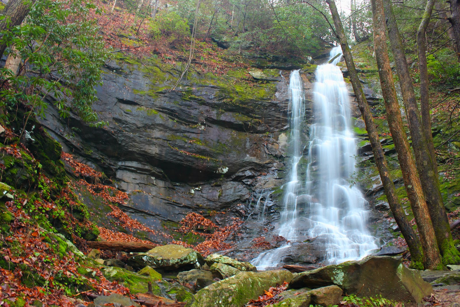
I was immediately surprised by the size of the falls, I had seen them listed at 30ft but they were at least 50ft if not more. They were very photogenic too,with a multilevel drop and a big pool at the base. Steve was also impressed and took time to climb up each level and splash around the falls.We both were not looking forward to climbing the rocky bank so instead we made our way down the trail back to the parking lot for Big Bradley even though it added a mile to our hike.
final approach to Big Bradley Falls
My favorite shot of the falls
tough terrain all around

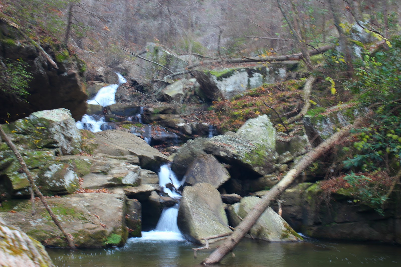
We made a brief pit stop to eat at Subway before tackling the base hike to Big Bradley. To hike in from the bottom of the gorge we took Green River Cove road to the river level. I have never been on a more gnarly and steep road. You can see the road below you up to 10 times! Once the road reaches the river there is a small dirt road just before the Green River on the right, we took this road staying with the river to the forest gate. Several other vehicles were parked so I expected to see some other people on our hike. The first part of the hike is along a dirt road and is inside the North Carolina game lands, so you should wear orange to keep from getting shot (we didn't). The road eventually swung wide to the left and we stayed right following Cove Creek into the woods. Eventually we arrived at a field but easily picked up the trail on the far side, and was back in the woods still following the creek. The trail really started to wear on us on this stretch, there were lots of downed trees and up and down climbing. At the first ford of Cove Creek we couldn't find a good crossing and ended up getting our feet wet. The trail becomes barely discernible and climbs steeply, Cove Creek is now on our right and we were saddened to see two nice waterfalls hidden far below us in the gorge. The trail leveled briefly high above Cove Creek and descends to rejoin the creek at a left hairpin turn. Across the way, a small stream enters on the right, I recognized it to be Casey Branch and told Steve we needed to follow Cove Creek on the left instead of crossing. There literally is no trail instead it's about a foot wide path possibly followed by deer along the creek, we fought our way up the path and it eventually faded at a flat spot about 20 feet above the creek, from here we could either slide down to the creek and wade or climb a near vertical rock cliff and see if we could get around that way. We chose the creek and made it only a few yards upstream before a massive cascade cut us off surrounded by rock cliffs. We made our way back and climbed the rock cliff, it was tough going, there wasn't many hand holds and when i made my way to the top things didn't look any better. At this point we were at least 70ft above Cove Creek. The path was back but maybe wide enough for heel to toe walking now. If you fall here, it's also death, you would plummet into the cascades below which are loud and from the looks of it violent. We actually debated on going on from here, but we felt if we took our time and leaned uphill we might make it. I tried not to look down only forward and after about 100 yards the trail widened a little and headed toward a massive rock cliff, we easily made our way along this section and the elevation decreased until we met the creek again. Just around a slight bend in the creek I got my first glimpse of Big Bradley Falls, I was so relieved and pumped we had made it!
Steve happy to be alive
Me at Big Bradley Falls

The view at the base is spectacular, Big Bradley is really unique looking and the surrounding cliff walls added to the solitude. I snapped away with my camera, and thought to myself, thank God these are turning out good because I will never return. I almost always want to go back after I visit a place, but even before the even more taxing hike out I knew I shouldn't tempt death too much, Big Bradley was indeed, a one and done. Steve sat in silence watching the water fall and I asked him what he thought, he too agreed we should never come back. As I write this a day later, my knee, feet, and even shoulder hurt. I also rolled my ankle coming out and have been hopping around trying to loosen it up. Big Bradley and Little Bradley Falls are absolutely beautiful, unfortunately they are also very dangerous and not to be taken lightly. I really struggled here and until there is news of better developed trail systems I will not do it again. This post is dedicated to the people who have lost their lives there, and I hope it serves as a warning to others in the future. Until next time, happy and safe trails.


In memory of


Friday, November 2, 2012

There's an old saying, "sometimes the sun even shines on a dog's rear end." The same can be said about the Roan Highlands. I can remember setting off for Carver's Gap on many occasions with a crystal clear sky only to be swallowed up by clouds atop the balds of Roan.
Ice covered fence post leaving Carver's Gap

Recently, a cold front collided with Hurricane Sandy as it was making it's way up the eastern seaboard and dumped over a foot of snow on the Roan Highlands. Thursday, I had the chance to get up on the mountain and the scenery was almost surreal. Here is some pictures of my day, I can honestly say they don't do it justice, I had never seen anything like it. Enjoy, and...happy trails.
Mt. Mitchell on the horizon
Frozen barbwire
pine tree branches

Hump Mountain
deep drifts were everywhere
congrats, TDOT!

Sunday, October 21, 2012

Dad and I have become really good hiking partners. Earlier in the year, he hiked four miles through the hills of Giles County to the Cascades of Virginia with me, it was one of my fondest memories. I remember a time when our family wondered if he would ever be the same after falling almost 30 feet off a telephone pole and breaking his back. The injury resulted in his retirement but opened the door for us to finally get to spend some time together. As time went on, Dad started doing better and feeling better, he worked on maintaining a healthier weight and had some nagging knee issues addressed and a hiker was born. I have been all over our region of Northeast Tennessee and Southwest Virginia and have seen some beautiful sights. Some of the hikes take every ounce of my energy and some are a little more tame, those are my "dad hikes"
Dad looking excited to head up.
awesome mix of fall color climbing the tower.

The Birch Knob Tower in Clintwood, Virginia is a crazy long drive for a wonderful short hike. I'm not sure who secured the funding to construct the tower, but I wish I could give them a hug. The structure is built around the boulders atop Pine Mountain and winds up and around the massive rocks eventually reaching a large observation deck with bench seating to take in the views. Dad had mentioned riding up there on several occasions but now that Fall is in full swing and the leaves are peaked we picked last Thursday to hit the mountains. The ride over to Clintwood is a pretty one crossing Powell Mountain and winding through the small mountain town of Pound, Virginia. Our conversation made the time go by and before we knew it we were heading up the first of 187 steps that take you to the top of Birch Knob Tower.
awesome picture of dad.
from the observation deck

It was a perfect day for photos with clouds rolling through mixed with patches of blue sky. The wind was gusting pretty bad at the top but I let dad borrow my sweatshirt to keep him up there with me. I hope these pictures tell the story better than I have, I'm having some serious writer's block and Sunday Night Football is on. Til next time...happy trails.
wind turning the leaves
Airplane Rock