Thursday, August 22, 2013

Twisted and Compression Falls are separated by a half mile stretch of river. A half mile in the grand scheme of things seems like such a small distance, but for photography and all the camera equipment involved it is the most difficult of terrains. Compression Falls alone presents many challenges. The trail to the river is a vertical and I mean a vertical descent. It's the kind of trail that you use as a difficulty scale on all other hikes, but don't let your guard down when you reach the river, there is plenty more treachery ahead.
This is the view you have of Compression Falls when the trail reaches the river.

Once at the river, Compression Falls is visible upstream. There's an obvious trail leading up toward the base of the falls but it's strewn with boulders and tree roots, all of which could easily break an ankle. Just before the falls a large slab of rock shields you from getting an obstructed view of the entire thing, add the massive spray zone from the falls and it's a troubling thought for camera owners. I use a water resistant camera bag cover and usually opt to wade the river around the boulder using a narrow ledge along a deep pool to work my way eventually onto the rock slab and a full view of Compression Falls. The falls photograph well especially in cloud cover,  it also increases the odds that people won't be swarming all over the place as Compression is a wildly popular swimming hole. To keep going upstream you must cross the river at the base of the falls and the bedrock here is slick from years of water erosion. If you make it without being swept over the shoals downstream, a difficult cliff climb awaits to make it to the top of the falls. The top of Compression Falls is one of my favorite places I've ever been. The view downstream is beautiful and a large deep narrow channel runs to the base of about a twenty foot waterfall upstream.
Compression Falls.
I took this photo from my knees in front of a cascade at the falls.

Sadly, this is as far as I've been upstream. Twisted Falls is still a quarter mile away and requires a river swim and rope climb up a rock wall to reach it's base, making it rarely photographed....UNTIL last Saturday.
Cascades at Compression Falls.


Steve and I had both been on vacation the previous week but we didn't go on a single hike. A few months earlier, we had discovered a second steep descent to the river on the forest road above Compression Falls parking but had ran low on daylight and had to wait for another day. I found a blog post that described the trail and was delighted to find it also mentioned a "ninja trail" that leads to clear views of Twisted Falls for photographs from a cliff high above the river. A ninja trail is best described as a trail that's often hidden from view and many times dangerous to your health, and Steve and I would discover, that was correct on both accounts.

We arrived at the parking for Compression Falls which has seen major renovations with a nice large graded dirt parking lot. Unfortunately, it's also seen about forty straight days of rain and is rutted and ruined so we parked along the old forest road near the gate and started up toward the spur trail above Compression Falls.
The trail is a can't miss it's wide and rutted. It's just as steep as the other trail but there are trees and roots to use to help you along the way. The trail reaches the river at a very beautiful beach like area. Across the river a side stream enters via a 30ft waterfall, a wonderful treat and bonus falls! Downstream the river picks up steam as it nears the top of Twisted Falls. We wound down the bank beating our way through laurel and driftwood. Lots of nice cascades are in this section and a large shelf falls dropping the river about 10ft as it roars toward the boulders that \pinch or should I say "twist" the river through the falls. The trail dead ends at a large sloped rock that is angled toward the river. The rock was dry so we were able to walk along it closer toward the top of the waterfall. A large slab of rock waist high has to be negotiated here and I went first making it on top of it, and as I slid off the back side I used a small bush to steady myself and was immediately greeted with a burning sensation just under my arm. I turned and got another swift burn to my head! BEES! I unleashed a torrent of colorful language warning Steve of the danger still unware that I held the very limb that had the hornets attached to it. I decided as I danced wildly along the cliff my best course of action would be to retreat into the woods. As I scrambled back up the rock, I used the same branch as a hand hold once again and was lit up on my legs a few more times for good measure. Steve meanwhile laughed hysterically at seeing me in my misery from a safe distance downstream. When I made the edge of the woods, my feet flew out from under me and I got to bash my face on the rock as well. I crawled into the woods as I could still hear the bees swarming me and met yet another obstacle, thorn bushes. I shredded through them as they shredded through my arms and legs before I mercifully found a clearing to ditch my gear and roll around to make sure there weren't any strays in my clothes. Steve joined me a short time later and was still laughing at seeing that hornets nest shake wildly while I screamed in pain, he is after all, my best friend.
Side stream unnamed waterfall.

First Cascades nearing Twisted Falls.
Tricky spot requiring a hop to the next rock.
Made the jump, heading downstream.
The large shelf falls.
Shortly before I got in the hornets nest and getting higher on the rock.

In my terror and blindly thrashing through the woods, I had found our ninja trail. A faint narrow path travels uphill around a towering cliff at the top of Twisted Falls. Steve took the lead and we made it to the top to see that we were directly above a vertical drop to the river and the trail was foot in front of foot to swing around a rock that kind of stuck out about head level with me. Steve took a couple steps before one of the more terrifying things I've seen happened. He slipped with one leg completely kicking out the side of the cliff, he took his hand down to balance before scrambling around the danger. I felt my heart in my throat when I saw that happen and was amazed he regained his balance. He turned around only slightly rattled, looking at what might have been. I took my time and didn't have any problem making it although it made me very nervous. The trail gets a little better and winds deeper into the woods before swinging you out on the rocky cliff where you can finally see Twisted Falls. The rock cliff is sloped toward the river and a steep drop that would be fatal if you were to fall, so I scooted out to one of the only trees on the rock and kind of braced my foot on it while I worked to get pictures. The falls looked fantastic and I snapped photo after photo before making a few videos and packing up for the hike back out. Steve and I were stoked at our discovery and to be reunited on the trail. My hornet stings hurt but the satisfaction of what we had done outweighed my pain. We both vowed to come back and further explore the area when we had more time. The ninja trail continued down river and I'm sure we could make it connect with the Compression Falls trail. Until next time, happy trails.

Finally at the edge of the cliff.
Twisted Falls.
Last shot of Twisted Falls.

Monday, August 19, 2013

I spend a lot of time in the woods and have gained new experiences on each trip that ultimately make me a better hiker, and in a lot of ways, a better person. Each time I complete a difficult hike I look back on it with accomplishment and the confidence gained from it can't be expressed with words.

Recently I took a short, easy, almost a cheat of a hike to Elrod Falls in Sneedville, Tennessee. It was third trip to the waterfall and second time in a period of two weeks. Steve and I were there prior to me getting my upgraded camera and the flow was fantastic and even with a point and shoot I got some good pictures. When I got my new camera and it had rained for a few days, I knew exactly where I wanted to go to try it out, Elrod Falls. There are three falls on the creek and they all happen in succession. The first falls is a sliding cascade with the second and third falls being more of a free fall. The first two falls are each 100ft high with the third only coming in at about 30ft. The trip to the falls takes about an hour from the house and I waited until late in the day trying to arrive just an hour before sunset to avoid the crowds and the lighting at the time is good for taking photos. It was overcast that evening and as I neared Sneedville I passed through a fairly heavy rainstorm.
The trail arrives at the sloped rock.

As I neared the parking lot, the rain had quit and I could see the first waterfall from where I parked. There was one other vehicle there but I could see the people hiking back out so I was excited I didn't have to try to be too creative in shooting the falls to avoid having someone in the picture. The trail is flat and leads to a tricky rock slope just before the base. I had on my water shoes so I just went into the water to avoid sliding on the rock and meeting the same fate as my friend Brandon did on my first visit there. (it was hilarious) I got some quick pictures from the base and crossed the creek to climb the steep trail to the top of the falls and on to the second falls.
Lower falls 100ft

The trail was really muddy from the rain and it stuck in the tread of my shoes rendering them useless for traction. There is a rope from tree to tree to assist in the climb and if not for it I wouldn't have been able to get up the bank. Near the top I noticed the trail widened more than I had ever seen with foot prints dangerously close to the edge of the cliff. I stayed close to the far side and was using a tree to assist me on up the cliff when I felt something brush my hand. I looked up to see my hand was inches away from a hole in the tree branch that had yellow jackets flying in and out! I quickly pulled my hand away and spun in a reverse pivot to further myself from the danger. Before I had time to react or balance myself both feet flew out from under me and I slid feet first over the cliff. As I was sliding up to my hips out over the open air I flipped over and found a grip on a tree root and swung into the side of the rocky bank gut first. There was a few places my feet would fit on the side and I was able to pull myself back up to safety. At the time it didn't rattle me, but after I examined where I had just been hanging it was obvious I could have been killed. I went on to the top of the falls and sat down gathering my thoughts and steadying my nerves. I turned to see the second falls through the trees, it's one of my favorite ones in east Tennessee. It has a unique look and it too towers at around 100ft. I took some pictures and waded around the creek, there is another falls further upstream but requires another vertical climb and I wasn't pushing my luck any further.
Near where I fell from the rocks (Amber on a previous trip)

This is just over halfway up along the cliff. You can see why a fall would be trouble. (previous trip)
Second Falls on the creek and my favorite.
Second Falls near the base.

With all my experience, not paying attention for just a moment almost cost me my life. I almost didn't tell anyone because of the grief I would receive for hiking alone and being careless, but I eventually told Amber and my parents, who indeed, scolded me. I have since been on several more hikes, but I have stayed vigilant to the danger involved in the trips and just how precious life is. Until next time, happy trails.

Monday, August 5, 2013

Last year as I staggered out of the woods near US19E, I promised myself that I had hiked for the last time across Hump Mountain. I had perfect weather that day and what started out as a short hike to Grassy Ridge turned into a 13.7 mile journey across some of the most beautiful scenery the Appalachian Trail has to offer. Luckily, I gained cell service on Yellow Mountain to alert Amber to my whereabouts and when to pick me up along the road or I may still be up there to this day. Normally, I tell several people where I'm going and how long I will be gone but that day I had felt really good once I got to Grassy Ridge and decided to continue on until I decided I needed to head back. From Grassy Ridge the AT drops in elevation significantly and eventually arrives at Yellow Mountain Gap. Once I got to the gap and got my first view back toward Carver's Gap I knew I had come to far to turn back and get out before dark, I would have to hike on toward Hump Mountain and eventually US19E. I was ill prepared for the climbs ahead of me, ran out of water on Little Hump Mountain, and my ankle socks weren't enough padding causing me to lose several toenails and have blisters on both heels. But like many of my adventures, once I got home licked my wounds, and loaded the pictures, the thought of doing a return hike suddenly didn't seem so bad.
Shane in the fog, near Grassy Ridge.
Old tree just before the Stan Murray Shelter.

I mentioned the hike to my friend Shane awhile back, and he agreed to go, noting that it would be the longest hike he had attempted. Each day leading up to the hike my excitement grew and yesterday we found ourselves on the way to Carver's Gap to tackle Hump Mountain once again. Hump Mountain is quite ominous and can be seen from miles away. Adding to the legend, is the difficulty in getting there. The route we chose, although longer, is listed as the "easier" of the two choices. Hikers can choose to hike from 19E to Hump Mountain but over five grueling uphill miles and rough trail separates them from their prize. We arrived at Carver's Gap around 9am and was completely engulfed in fog. Adding to my concern was the whipping wind and cool temperatures since I only had a t-shirt and shorts on, but we had came to conquer the mountain and we got our gear on and set off up the balds.
First rays of sunshine.

Taken from sitting inside the Overmountain Shelter.
Overmountain Shelter from Yellow Mountain. The Balds still covered in fog in background.
Gray's Lily, a rare and endangered flower only found in the southeren Appalachians.

Our pace was rather fast and we clipped off Round and Jane Bald within the first hour. We rested on Jane hoping to see a break in the fog but it refused to budge. I asked Shane what the weather was supposed to do he said, "beautiful, my phone showed a sun ball." We both had a good laugh and continued on toward the Grassy Ridge spur trail taking the AT North toward the Stan Murray Shelter and Yellow Mountain Gap. The trail enters the woods here and with all the fog it was almost eerie hiking along, at times it felt like the woods would swallow us whole. We arrived at the Stan Murray Shelter to find it empty with the exception of some trail journals and I took time to read both books, laughing at some of the entries. I recorded our trip listing our trail names as Freak Nasty and the King of Kentucky, shamelessly plugged my blog and we were on our way. In a couple of miles the trail arrives at Yellow Mountain Gap and a trail junction. Both Shane and I are history junkies, and on the spot we stood in Yellow Mountain Gap was where the Overmountain Men marched through the Roan Highlands in route to eventual victory at Kings Mountain over the British Army. Shane was well versed on the history of the Overmountain Men and marveled at the significance of that spot and the fact that farmers were able to advance on a trained army and slaughter them.
Little Hump Mountain.
Shane takes the lead up Little Hump Mountain.
Lunch near the summit of Little Hump.

We took the short spur trail down to the Overmountain Shelter which is a renovated red barn that sits in the gap. The sun finally made an appearance and the views down the valley were spectacular! Both Shane and I were energized by the break in the weather and took a short break at the barn with a few other hikers before continuing on. Our energy was short lived because the trail takes a steep turn up Yellow Mountain and with no shade, the sun was zapping our strength quickly. Several rest breaks up Yellow Mountain and we finally reentered the woods and started the turn downhill and our first sight of the Humps.
First view of Hump Mountain.
Heading toward Bradley Gap and Hump Moutain looming large.
The AT heading through Bradley Gap.

Little Hump Mountain is a nice rolling ridge surrounded by beautiful scenery. The AT drops into the valley at it's base forcing you to climb the entire mountain. Shane and I both took breaks frequently and the breeze was a wonderful feeling as we labored up the long grade. We arrived at some rock outcrops and found an older couple taking lunch so we decided to join them, and to this day I haven't had a better tasting fig newton. I cautioned Shane not to get upset with me once we crossed Little Hump and got our first good view of Hump Mountain, and he cautioned me to stay out of arms reach. As I summited Little Hump, I saw the mighty mountain rising in the distance and looked back to see Shane's reaction. If I had a video camera I could pinpoint the exact moment his stomach turned,  and after he exchanged some pleasantries with me, we continued on.
Another view of Hump Mountain.
The trail is in rough shape through Bradley Gap. Lots of opportunities to turn an ankle.

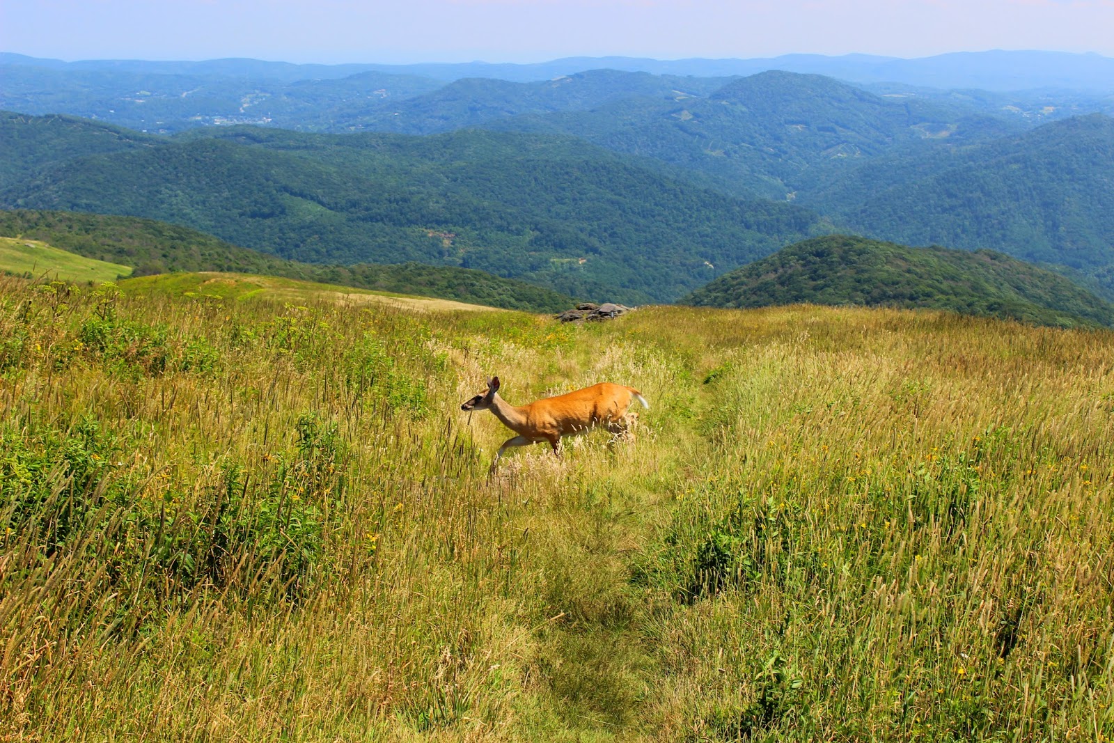
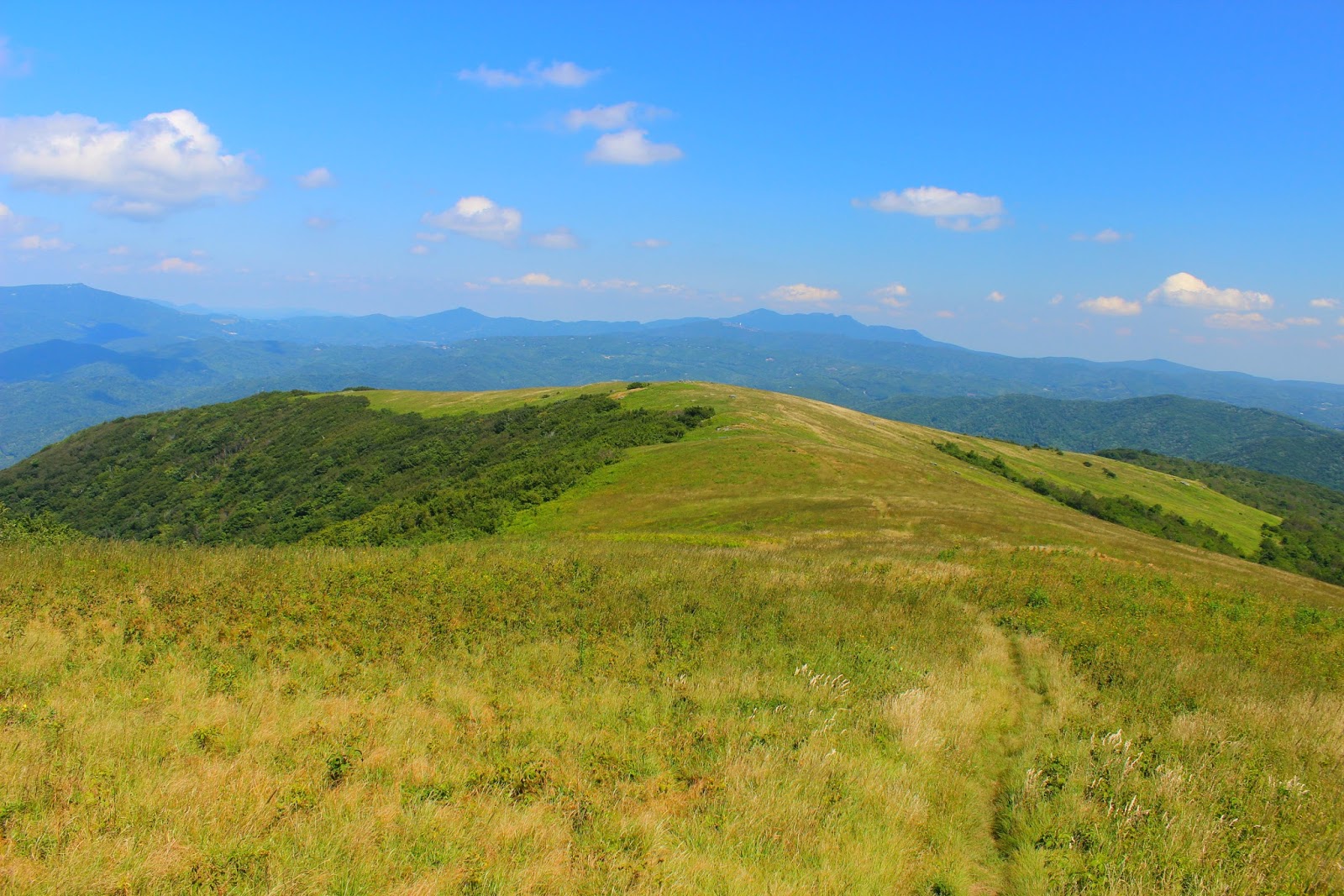
Once again the trail loses all the precious elevation you just gained and Hump Mountain grows larger and more gut wrenching with every step. The valley before Hump Mountain is known as Bradley Gap and the wind was roaring in this area. The grass looked alive dancing with the wind and soon we were beginning the first steps up the mountain. We made goals with landmarks and trudged from one to the other resting at each one. Half way up the mountain is a large set of boulders, we took an extended break here, fully appreciating just how far we had come. Round Bald was now a tiny dot on the horizon, we could see deep into the Linville Gorge, and Grandfather Mountain was visible to our right. Both our spirits were lifted by the sense of accomplishment and we pushed forward passing the horse gate that leads to the summit of the mountain. A scout troop was heading down the mountain with loaded packs and as I was watching them, I noticed a deer jump from the trail and spring through the waist high grass.
Grandfather Mountain off to the right of Hump Mountain.
Looking back to Little Hump.

Soon Shane and I were taking the final steps onto the summit of Hump Mountain. I unhooked my packs and dropped my camera bag, the views were truly stunning. Suddenly, Shane yelled, "Jason, get it" I turned around to see the deer from earlier no more than 15ft from us just starring back at me. I snapped off a few photos convinced it would flee at any second, but it stayed with us the entire time. At one point, Shane got within arms reach of the doe, it was one of the most amazing things I've seen while hiking. We both rested while our new friend grazed the balds on the mountaintop. I took picture after picture still in complete awe of the scenery before us. Shane shared some more of his fig newtons and both of us were slow to want to get back to our feet. Although we had reached the summit of Hump Mountain, we still had a difficult five miles ahead of us.
Winding up Hump.
Horse gate near the summit.
Almost up top!
Summit!!!

The descent from Hump takes you through Houston Ridge, a long sloped area with more fantastic views. Hump Mountain's sharp face is visible from here and makes for some excellent shots. We arrived at the woods outside Houston Ridge and traversed perhaps the most difficult two miles of the hike. The trail is littered with boulders and my feet and knees were on fire with pain by the time we made it out. The Doll Flats is the next major landmark and is marked with your exit from North Carolina back into Tennessee and several nice campsites. We found a large rock in the woods to rest on and on to the tree next to it was a mile marker. We were now over 10 miles in but still had over three miles left! I was running low on water but luckily Shane had packed heavy and that last bottle of water helped me make it back to the road and our ride home.
Deer on Hump Mountain.
Shane, the deer whisperer.
Deer crossing the Appalachian Trail.
Grandfather Mountain from the summit.

Amber was waiting as agreed when we emerged from the woods and we all crammed in Steve's Camaro for the ride back to Carver's Gap. Both Shane and I were in good spirits considering the difficulty of the hike and we told Amber of all the adventure we had shared that day. When Shane and I made it back to my truck, we continued to rave about how perfect of a day it had been and began planning our next trip into the mountains. Hopefully this blog will halfway do this wonderful hike justice, it's not to be taken lightly but if you want to see the best the AT has to offer then this is a must. Until next time, happy trails!
Houston Ridge Memorial Plaque.
The full length of Houston Ridge.
The sharp face of Hump Mountain.