Monday, June 24, 2013

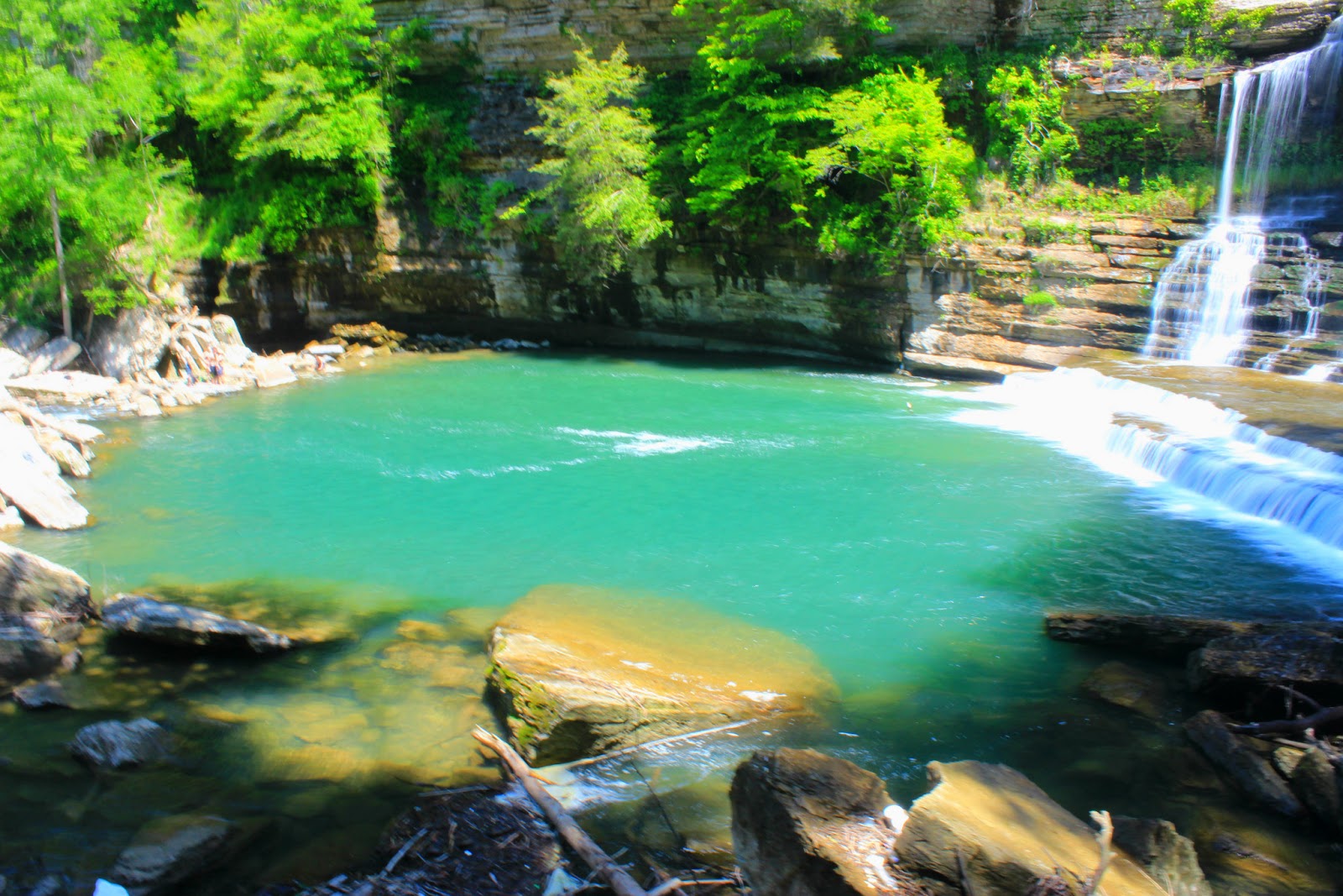
Another day another trip into the North Carolina mountains to seek out more waterfalls. Steve and I had just wrapped up our annual hiking trip to middle Tennessee and were anxious to hit the high country and even more so to see some great waterfalls. The first stop on our hiking itinerary that day was on the Thompson River. I personally love the place and rarely do you ever see another soul on your hikes there. It's sandwiched between Gorge's State Park and Whitewater Falls so being overlooked and underrated is kind of understandable. The parking is only a roadside pull off at the intersection of Brewer Road and NC 281, and there are no trail signs but the old logging road just up the hill is easy to follow and the paths are worn enough to know where to go. There are five waterfalls on the river and all would be the highlight of most hikes but we had plans only to see the High Falls on the river that day. A small trail branches off to the right as you near the first crossing of the river and travels along a steep grade above the river. The trail is a little overgrown so my face was constantly getting scratched by the tree limbs as I passed by. A short while later the waterfall could be heard downhill on our left, it's a steep scramble down the bank that arrives just downstream from the falls behind some boulders. We had to cross the river and some downed timber before we could see the falls from a small island in the river. The waterfall is almost 110ft high and slides into a deep pool at the base. It's kind of in a recessed cove almost hiding it until you are directly in front of it, the flow was good as well being much more powerful than my previous trip.
High Falls of the Thompson River
Vines along the Thompson River trail.
We spent some time at the falls before making the steep climb back to the main trail. It was early in the day so I suggested we visit the second falls on the river which as far as I know is unnamed. (there are three unnamed falls, the other two are High and Big Falls) The trail continues downhill and crosses the river above a ten foot waterfall that is unusually loud. Almost another mile in is the side path for the waterfall we were looking for and the path again is steep down the bank meeting the river below the falls. The unnamed falls was a nice one but not very high, the sun was shining brightly forcing me to use different camera settings than usual. A large rotten tree had fell from the opposite side of the river and it's rotten trunk had exploded all over the rock on the side of the river we were on. Steve immediately began shuffling through the pile of rotten bark looking for snakes. Almost instantly he found two and both were different kinds! The smaller of the two was a real fighter and it took him a few minutes to wrangle him for photos.
The first unnamed falls.
This guy was small but a real fighter!
Ring neck snake.
After we took turns handling the snakes, we hiked out of the Thompson River Gorge and on to the next waterfall on our list, White Owl Falls. White Owl is a small waterfall of only sixteen feet but it makes up for it with it's beauty. Many people are unaware of it's existence being hidden just below the busy highway 281, so I was surprised when I saw a pickup truck parked in the narrow pull off for the falls trail. I squeezed in beside it and it's owner was fiddling with some stuff in the bed of the truck and asked if we were going to White Owl. We introduced ourselves and found that he was Mark Morrison, an author from Georgia and was getting his measurements for a guidebook. I was thrilled to meet a real author and quickly offered to buy a book. Mark sold me his guidebook for Georgia, Alabama, and Tennessee and we became lost in conversation along the busy road telling of our many waterfall conquests. I asked him about Slippery Witch Falls located just down the road but he suggested we skip it due to the concern that it could be on private property. He instead offered a replacement falls, known as Silver Run Falls about twenty minutes away so we added it to our list for the day. We exchanged goodbyes, and Steve and I were on our way to White Owl. I was afraid Steve would be negative about the size of the falls but he was also impressed with it's photogenic nature.
White Owl Falls.
Back to the truck and another short drive to the pull off along 281 to another smaller but equally beautiful waterfall known as John's Jump Falls. It's literally just under the road bank and drops about 30ft over a big slab of rock. The last time I was here, I fell and my leg bowed awkwardly under me. I thought of how ironic would it be to get hurt badly so close to the road and possibly not be able to get help. The state had dumped a bunch of tree limbs right on the trail head so we swung around through the woods but were cut off from the main trail by briar thickets. We pushed through but both were bloodied pretty good by their thorns. All the pain was worth it when we stepped out into the creek to see the falls, they were magnificent. While wading around I found one of the largest chunks of Mica I had ever seen in the waters near the base.
John's Jump Falls.
John's Jump, a closer view.
When we got back to the truck Steve was really adamant about at least just checking the area at Slippery Witch out and see if it was posted. I didn't have directions but had read enough about the area to get us to the bridge just above the drop of the falls on the dirt road off of 281. We drove past the falls for half a mile without seeing any property signs and passed over the bridge and went another half mile or so still seeing nothing as far as property ownership goes. We went back to the bridge and parked at a narrow pull off. A clear trail was found under a power pole heading downstream. I was really skeptical but Steve said we would run down take our pictures and leave. We ran down the trail and I popped off a couple of pictures and we were on the run out within five minutes I had what I wanted, a picture. Unfortunately in my haste, I didn't check my lens and a few drops of water marred the outside edge of the photo, guess that's what I get, right, Mark?
Slippery Witch a beautiful 100ft drop.
Another shot of Slippery Witch.
The run out was tough and Steve was laughing at my gasps for air, he still was impressed that I was able to run up that grade without resting. We settled in for the drive into South Carolina and back up 107 to Silver Run Falls. When we arrived at the parking lot I was discouraged to see it crowded with cars and also that it was really narrow and in a blind curve. We had to drive up the road and turn and come back to try to get a spot. A very small spot was available and I slid in to it "a little hot" almost running over another hiker standing by his car. Steve laughed hysterically at him running out of the way as the dust cloud billowed on our arrival. Silver Run Falls is a nice waterfall and an easy hike, I'm not sure how high it was but I was most impressed with the deep wide pool at it's base. Between the dogs, children, and fat chicks at the base, photography was a challenge! I finally cropped the photos down enough to capture the falls but it was not what I was hoping to take home.
Silver Run Falls.
After a wonderful day of hiking we were on our way home. A quick meal at Wendy's in Cashiers and we headed toward Tennessee. During our conversation on the drive, I mentioned Kathy Creek Falls near Brevard and we decided to stop for one more waterfall (this happens a lot) Kathy Creek is a large 80ft cascade just a couple of miles off Highway 64. I had visited it before and was really impressed so I wanted Steve to see it as well. The road to the falls is narrow and steep and we parked high above the trail, giving us one more bank scramble to tame before home. The falls was beautiful and we both rested taking it all in, and talked of our next trip to North Carolina and another day of hiking and swimming. Until then, happy trails.
Kathy's Creek Falls.

Saturday, June 8, 2013

Steve and I took a day of rest before tackling the Wilson Creek area in North Carolina on Friday. The day of the hike I was feeling refreshed and was anxious to visit somewhere I had never been. Our first hike of the day was to North Harper Creek Falls and we found the trail head rather easily off of FR 58 near the Blue Ridge Parkway. North Harper Creek Trail gradually winds downhill following the stream and there are several creek crossings along the way. I didn't bother trying to keep my feet dry, the cold water worked as a good numbing agent and kept my mind off the burning blisters. After about a mile we came to the upper portion of the falls which is a long sliding cascade area that is roughly 100ft long. I found it to be really awesome and enjoyed the ability to climb along either side of the waterfall. Steve and I worked our way down the rocky slope and soon were at the top of the lower half of the waterfall which is almost a vertical drop of 40ft. We noticed a worn path on the opposite side of the creek from the main trail and used it to work our way to the base. There was a deep pool in a rocky trench to the left of the falls that was loaded with frogs and salamanders. The area was really beautiful but the sun was out so I had to wait as clouds would drift in to try to take photos. We stayed at the base until Steve had caught all the frogs for photos and I had got some good pictures of the waterfall. The hike up the trail back to the truck was only mildly strenuous and we made good time even though the heat was getting worse by the minute.
The sliding cascade at North Harper Creek.
Steve approaching the main drop of the waterfall.
Upper portion of the waterfall. left side.
Upper portion of the waterfall. right side.
The cascade looked shallow but was deeper and POWERFUL!
Deep water hole at the top of the falls.
Lower portion of North Harper Creek Falls.

We found our way back to the main forest road and traveled to the parking area for our next stop, Little Lost Cove Creek Falls. The night before our hike I had added it to the list and thought that both the upper and lower falls would be a good two for one. The trail head is on a seldom used forest road and it was gated, and instantly the hike was extended by two miles. Steve was aggravated that we were hiking on a road that the truck could easily handle but the downhill grade wasn't too extreme on our legs. As we made it to the side path for the first falls we found the trail to be rutted and steep. When we arrived at the creek the falls was really beautiful but there were a lot of yellow jackets flying around and we didn't stay too long to investigate. The waterfall is huge and is broken by a large flat boulder the area reminds me of a rain forest and the mist was a welcome natural air conditioner. The sun was bleaching out my photos pretty bad and I took a few hoping to salvage something once I got them on my laptop for editing. The climb out was tough and slick, not to mention that I was getting really hot and the laurel blooms were sticking to my clothes as I fought through the thickets. Back at the main trail we continued on the old forest road before taking a side rutted jeep road around some mud holes. The road was rough and we found the trail to the lower falls by a piece of flagging tape. It was evident not many people get down here. The path is nearly vertical and the leaves covering it were slick. I fell multiple times trying to reach it's base and Steve laughed hard each time. Once I fell directly on a log face first trying to get over a fallen tree, Steve waited a full second before erupting in laughter once again. The lower waterfall is the better of the falls in my opinion, unfortunately it's really difficult to photo the entire drop but it's a long steep sliding cascade. The hike down had gassed my legs and I rested by the creek while Steve turned over rocks looking for snakes. The hike out of there was TOUGH, by the time we reached the old jeep road I was gasping and had a mile and a half to hike to the truck. Steve kept the conversation going although he often answered his own questions and we arrived at the truck quicker than I thought we would.
Downstream from Upper Little Lost Cove Creek Falls.
The waterfall is much bigger than this picture indicates.
Lower Falls on Little Lost Cove Creek.
Lower Little Lost Cove Creek Falls.

Resting briefly, we almost decided to call it a day. I had a couple more waterfalls on the list, but I was hurting bad with the blisters and my legs were jelly. Steve also was tired but let me make the call. I decided to knock off one more waterfall before calling it a vacation. Bard Falls won out over Hunt Fish Falls and we were soon on our way to the North Harper Creek Trail shortcut that leads to the falls. This hike was really pleasant and gently switched down the mountain arriving at the creek in just over a mile. The trail follows North Harper Creek downstream for another mile passing several nice cascades and swimming holes. When we finally got within sight of Bard Falls I knew we had made a great choice. It's only about a 30ft waterfall but is gorgeous and features a really cool pothole to the left of the waterfall that can be climbed down inside of. Steve was as thrilled as me with the falls, and we both rested at it's base knowing that our hiking vacation was coming to a close.
Me inside the pothole at Bard Falls.
Bard Falls.
Further downstream from Bard Falls.
Awesome frog we found.

It's hard to believe that in four days on the trail we had seen over 30 waterfalls. Between the mountains of North Carolina and the plateau of middle Tennessee there isn't much better hiking to be found. Perhaps the most surprising part is that we have only touched a fraction of the waterfalls in Western North Carolina and there are several in Tennessee that have still eluded us. Hopefully I can get all of these knocked out and begin working on a guidebook of my own one day. Until then...happy trails.

Thursday, June 6, 2013

The sun rose on the third day of our middle Tennessee hiking trip and I was surprised that when my feet hit the floor I could walk and look somewhat normal even though my feet were shot. I followed the same routine of bandaging blisters and putting on my extra socks before finally lacing on the shoes for one more day in the wilderness.
Nearing the base of Burgess Falls.
Even with the water drops, an awesome sight!
Last shot of Burgess and maybe the best one I took that morning.

Our itinerary was much more reasonable that morning with stops at Burgess Falls, Cummins Falls, and finally visiting Rainbow Falls and the cave that it empties into on our way home. When we arrived at Burgess Falls I was thrilled to see that we were one of two cars in the parking lot and also relieved the sun was still tucked behind the mountains. The trail is easy and follows the river downstream passing a few other nice waterfalls that would be the highlight of most hiking trips. The middle falls is really beautiful but you view it from a cliff on the opposite side of the river. Due to time constraints I decided we would have to skip attempting to bushwhack up river to it's base for another time. A few minutes later we arrived at the overlook for the main falls. The only people there besides us were viewing the falls and we decided to hike on down to the base. The trail is steep but switchbacks down to the river just before the top of the falls. There is a nice caged walkway that lowers you over the cliff and down to a really good photo spot of the falls about halfway from the base. The river level was up since my last visit and the mist at the base was intense. I decided I had come far enough and began taking pictures. Steve couldn't stop there and continued on to the base. Eventually I couldn't stand it and followed him down there as well. The mist was quickly soaking through my shirt and I had my camera wrapped in it trying to protect it as best I could. I turned my back to the falls and shielded it long enough to shoot a quick picture off but it was still marred with water droplets. The sun had also made an untimely appearance just above the falls and the glare was enough to make me pack up and head back up the trail.

The next stop of the day was at Cummins Falls. I had never been there so I was excited to see it in person. The area was recently converted to a state park (for years it was private property) so I anticipated we might have company. When we arrived at the parking lot there were several cars but I was still hoping for a picture that would crop out any people. The trails are new and the area is signed well. We followed the downstream trail that led away from the falls and met the river about half a mile from the base. From there it's up to you to pick the best route back upstream to the base. We followed the left side of the river until it met some rock cliffs and crossed just above a shoal. There was a nice side stream waterfall near where we crossed. Negotiating the trail up to the falls was not an easy task. The path is rocky and lot's of driftwood piles litter the trail. I seen that the side we started on was looking easier and waded back just as I could get a view of the falls. Cummins was really beautiful. The waterfall is wide and cascades down wide looking steps at it's base. The pool is green, REAL green and absolutely massive. I imagine it gets crowded when the heat cranks up in midsummer. We took our time wading and getting pictures from all angles here. I found my favorite spot was underneath the rock cliffs on the left side because it gave me some shade from the sun. Steve, meanwhile, perched on a large rock across the pool staying vigilant for approaching college girls arriving to sun bathe. Eventually I had to tell Steve we had to go if we were going to hike anywhere else.
Me and this guy kept a similar pace.
Cummins Falls.
What a swimming hole!
It's hard to scale just how massive this is.

The drive from Cummins to our next stop was on a curvy, boring road. Rainbow Falls was listed in the guidebook as being "possibly" on private land but the directions were provided anyway. The trail head was at a cemetery (never a good omen) and we had to find the main trail just off a logging road in the woods to our left. Steve was pumped to see another 110ft waterfall that vanished into a cave and led the way. We followed a logging road and saw no signs of life with the exception of an empty mountain dew can from the 80's. We crossed over a mountain in a mile and even though we had the book with us could never find the trail! Steve began getting flustered and started striking out through the woods at random places to see if he could hear or see anything that would clue us in. Each time he rejoined me, his language grew more colorful. We eventually decided that the directions were outdated since we had found several new roads crisscrossing the mountain and that we could find it ourselves. We found a creek and tried to trace it upstream, the wet clay mud on the banks was slippery and soon I found myself lying on my back staring up at Steve laughing hysterically. I found my hat and sunglasses and continued on. I realized we were not going to find it and found a rock to rest on while Steve trudged on. After thirty minutes, I began to worry but soon I could hear faint cussing and fussing coming back in my direction that I knew had to be him. He told me if the guidebook wasn't mine he would have chucked it into the creek and stomped it dry.

I reminded him of our success and of the many good times we had experienced just in those few days. He didn't want to hear any of it but by the time we made it to the truck he was already cracking jokes at how angry he had been just a few minutes earlier. All told we had seen 27 waterfalls. I was bummed that our final stop was a failure but it gave us a challenge to seek out next time we were in the area. When we finally pulled in at my house that night. I could barely unfold out of the truck, we decided we would take the next day off before hitting the mountains of North Carolina on Friday morning...to be continued...