Thursday, December 20, 2018

Sometime in the year 1999, Ford Motor Company produced it's 2000 model Ford Explorer Ltd fresh off the line with all the bells and whistles. To have seen it then would have been to behold one of the finest vehicles in all of America.
Scott and his faithful sidekick, Gomer.

Nearly 20 years later and countless memories made and miles went by, the same Ford Explorer Ltd found it's way into my life by being the preferred chariot for transport for waterfall adventuring by my buddy, Scott McGaha. The vehicle and Scott could not be more perfectly suited for one another.

On this particular day, I sat in the parking lot of the Gorges State Park Visitor Center awaiting Scott's arrival as a steady rain fell on the roof of my truck. Katie sat next to me patiently tucking all her gear away in an already busting at the seams backpack. Beside us in the lot was Tracie loudly jamming to whatever tune was passing time until the final member of our party arrived. Scott was late. Scott is always late, but he has a way of presenting it that keeps you from being overly upset with him.

Nearly 30 minutes passed before a vehicle came careening down the curvy road wheeled in next to us and rocked to an abrupt stop. Our ride had arrived. The Ford Explorer at first glance looked good despite some obvious age and we all grabbed our gear in attempt to load up. We quickly discovered a tricky sequence of door handle use was required for entry into Scott's SUV.
Scott was in full story mode from the time his foot hit the payment. "Hey sorry I'm late guys, Gomer didn't want to start and I had to jiggle the cables for a bit to get him fired up." The car had a name, of course it did.  I pulled on a door handle that didn't work as he continued. "Oh yeah, the handle is messed up you gotta open it on the inside and the back one doesn't work at all.' All of this was said with a wide smile smacked across his face. "It's a heck of a car though and has been in some of the roughest places you can imagine, some of those places we will be seeing today!" I was nervous already.
Please dont let me die today.

Our mission for this day was pretty simple. Ride along Chestnut Mountain Road until it intersected Auger Hole Road at Turkey Pen Gap and descend deep into the gorges to Scott's shortcut to see Bearcamp Falls and Lower Bearwallow Falls. Tracie and Katie were wedged firmly in the backseat along with our packs and cooler bags. I cramped into the front seat next to Scott and we were off after he jammed it into gear. "Transmissions been trying to go out on me," he said.

The paved road led us down a hill to a large parking area for access to Rainbow and Turtleback Falls. Seeing so many cars there that early in the day was a little staggering considering Ive hiked there years ago without a seeing a soul. At the end of the lot a gravel road begins along with a large wooden sign of warnings and regulations, we were on Chestnut Mountain Road. Growing up in Scott County, Va a dirt road doesn't phase me and CMR was in good shape as far as gravel roads go. There were several insanely steep sections that required me to hold Gomer's radio in it's harness. And on the steep descents, Scott had to continually turn off the windshield wipers my knee slamming into the on switch on his dash kept turning on. The brakes were already hot as we approached Turkey Pen Gap but Scott was unphased; together he and Gomer were invincible.

The beautiful thing about the friendship between the four of us is if we're in danger we're always laughing too hard to realize it until after the fact. The girls bounced around the backseat as Scott picked up steam wheeling around Turkey Pen Gap and we caught up to some young kids in some brand new lifted Jeeps. Scott decided to stop so we could watch them from above and we all got a good hearty laugh watching them crawl around all the mud holes as the road dropped us down closer to the Horsepasture River. Eventually we caught our Jeep friends again as they were stopped on the river bridge taking photos of their rides. We lined up behind them and waited. One of the boys finally noticed us and came over to the driver's side window. Scott asked him what they were doing and he asked Scott what our plan was. Scott said, "Well I'm gonna cross this bridge and go to a waterfall over near the South Carolina border when y'all move your Jeeps." The boy's eyes widened and he said, "oh you can't go any further than the bridge the road is in too bad of shape from all the rain we've had." Scott chuckled momentarily and said, "pull over and I'll show you." (Please keep in mind it's still raining.)
Gomer parked next to the Tercel.
What a ride that must have been!

We watched as each Jeep pulled off to the side of the bridge before it was our turn. The bridge over the Horsepasture is a metal slab with about a two inch lip on either side and the ramps on either end are large stones laid in place to raise the bridge high enough to avoid flood waters. Getting on the bridge was a piece of cake for Gomer but the opposite side was rutted badly and all the boys had lined up to watch our demise. Scott stomped it and we scraped across the boulders before bouncing so hard my entire weight was lifted off the seat. I caught a glimpse of them looking defeated as we slung mud climbing the opposite side of the ridge.
Ttacie and Katie making their way up Auger Hole Road.

Scott was pumped up. He laughed wildly and we slid up the ridge avoiding trees and boulders like he was some sort of professional wheelman. Our luck would be short lived when we came to a rock that slowed us enough that we became temporarily stuck. Scott and I exited Gomer and looked for a solution. Uncle Jim paid me a visit in the form of inspiration. When I was young he would has us help him lay rock to get out of muddy spots in his road so I told Scott we just needed to build enough road to get around the largest of the rocks. We moved several stones and sticks and made a track that would make the most hardcore redneck proud. Scott jumped back in while i stayed outside to direct him over our engineering marvel. Sure enough it worked and I climbed back in to continue our harrowing ascent up the ridge.

Despite Scott's confidence, he did admit the road was in terrible shape and said if we did get stuck he would just leave Gomer and we would hike out and "wait for it to dry up enough to come back and get him." Katie seemed unphased by all of it but Tracie shared in some of my concern and we cautioned Scott when we came to obstacles. Soon we had developed a system of me getting out and flipping rocks out of the way and Scott carefully squeezing by. It sounds corny, but it worked and we all felt more like a team as our ride took us deeper into the gorges. The road soon disintegrated into a mess of red clay mud and traction was tough to come by, on several stretches I was convinced we would never make it back.

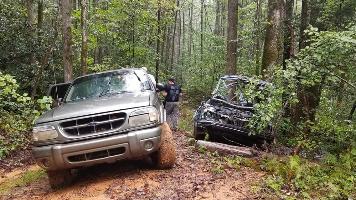
Luckily persistence and common sense prevailed and Scott found a rutted out old forest road wide enough to park Gomer so we could hike the remainder of the way to the falls. Surprisingly there was another car there as well, although it looked like it may have been there for decades. The Toyota Tercel wagon was riddled with bullet holes and missing anything of value. The person that drove it there to begin with probably has never been able to walk since from having such big balls. The Auger Hole road had been reduced to soup and although I felt better about being on my feet walking, it wasn't much easier. We picked a narrow track along the edge of the road as we climbed around a ridge to find a tree across the road, apparently the good Lord was watching over us. Scott surveyed the tree before looking back at me, "I believe we could have went under that, might have scraped a bit though" before busting out with laughter.
"We might have scraped."

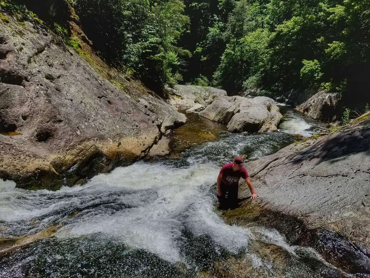
The road leveled off and Scott jumped into the woods following an overgrown ridge line off to the left. I was under the impression we would be hiking trails but this was Scott's famous Bearcamp shorcut. This waterfall seemed as if it would cause me the most trouble of all of the Carolina Mountain Club challenge facing a 12 mile hike for most folks but with Gomer's wheels and Scott's guts we were gonna hike less than half a mile. Soon we were sliding down a steep bank toward the sound of falling water. Bearcamp came into view, and it was a stunner. The majority of the falls slid over a massive wall of rock before the final 15ft free fall into a large but shallow pool. You could walk behind the veil and Katie and I both played along the falls as Scott and Tracie looked on. Eventually I joined them and full blown story session ensued. Katie snapped a picture of us all there that now proudly hangs on the wall in my home.
The beautiful Bearcamp Falls.
Peace out, Bearcamp! Photo by Katie.

The hike out was a piece of cake and soon we found ourselves reunited with Gomer. We all loaded up and Scott turned the key to nothing. Like completely dead. He didn't panic but had me pop the hood which I couldn't find the latch for, and then expected me to know how to remove the battery cables and "smack em into it until you see some fire" which I also failed but Scott was able to get Tracie to man the wheel long enough to get us cranked and back on our way...hopefully. The occasional rock had to be removed by yours truly but for the most part the ride back to the river was kind of pleasant. The red clay mud I dreaded so badly Scott maneuvered through like a champ and Gomer had just enough speed to pull us over the hard part. When we arrived at the river. I exited the vehicle and tried to eyeball our best route. Several large gaps needed to be filled just to get on the bridge so the four of us all carried various sized stones and rebuilt the access ramp. It looked rough but doable. I suggested I should film the sequence and Tracie walked the bridge to film from the opposite side.
Rebuilding the bridge over the Horsepasture.
Scott and Katie prepare for launch.

Katie road shotgun and squealed loudly as Scott laid the pedal to it to move over a rock he was jammed on and soon they popped up on the ramp with our rocks shifting ever so slightly and onto the bridge! He drove to the other side and waited for me to join them. Once in tbe truck, I replayed the video that showed how narrowly he had came to sliding off the bridge. Scott's eyes got wide as he said, "Man! I almost drove it in the river!" He then settled into another gut busting round of laughter before stomping the accelerator heading toward Turkey Pen Gap.

Road hazzard clear!

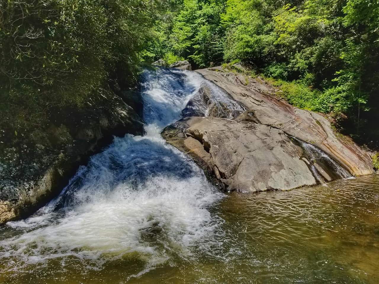
At Turkey Pen Gap, several roads branch off including a continuation of the Auger Hole but it's gated (thank God) From there we would road walk before visiting our final falls of the day at Lower Bearwallow. I've not seen Katie so amped up as she set a blistering pace to the ridge we would descend to the base of the falls. Scott caught up with us and fixed some rope down the steepest sections as we followed close behind. When I caught up to Scott I was almost staggering as I was overwhelmed at what a great waterfall I was seeing. A beautiful free fall of about 35ft that catches several small ledges before emptying into an incredible swimming hole. Before I could turn to see where Katie and Tracie where I heard a loud splash as Katie was swimming as hard as she could to go sit on the falls!
Me and Katie playing at Lower Bearwallow. Photo by Tracie.
Me and Tracie at Lower Bearwallow. Photo by Scott.

I stalked around the pool before taking a more gentle approach into the pool and after some mild persuading I talked Tracie into jumping in with us as well. Scott looked on while the three of us played and savored one of my new all time favorite  waterfalls. We all regrouped at the base and enjoyed a snack before our steep climb out to the Auger Hole but what a day it had been!
Scott's rope really helped on the climb out.


What a great group of adventure buddies!

With only a few miles of Chestnut Mountain Road separating us from our vehicle old Gomer saved his best for last, firing on the first turn of the key. Scott had me back on holding the radio in it's place duty as we bounced out of the gorges and toward some dry clothes and hot food. Its hard for anyone to appreciate the ruggedness of the gorges that surround Lake Jocassee but if you've been there it will be easy for you to relate to this blog. And as for Gomer, the last I saw of him was his taillights riding into the South Carolina night as Scott turned for home. Built Ford Tough...I agree.

Tuesday, December 18, 2018

This past week has been such a challenge for me. I awoke Wednesday with stomach pain and tried to fight off so I could go hiking but by mid morning I was at the hospital and by that evening I was in surgery for an emergency appendectomy. Although the surgery was a success, I now face my longest layoff from the trails in my life. But in sticking with my silver lining mentality, I'm going to use the time to catch up on some blogs that have been filed away in the memory banks.
The beginning. Back when everyone was happy.

The logging road showed no mercy.

First up is this year's Black Friday hike or as it's now known by most outdoorsy folks, Opt Outside. I'm not sure how this happened but each year my #OPTOUTSIDE hike has pushed the envelope a little further each time. This year I had only one trail in mind, the incredibly difficult Woody Ridge Trail that stretchs only 2.6 miles but gains 3100ft to meet the Black Mountain Crest Trail between Celo Knob and Mt. Gibbs. A quick Google search will yield descriptions such as, insane, unrelenting, ridiculous, and maybe my favorite, "the hardest maintained trail in the state of North Carolina."
A frozen  spider web along the trail.

Sallie and I enjoying a break heading up.

Unfortunately for Kip, he's my friend and as part of that friendship I always drag him along on these #optoutside hikes with me. Even more troubling is the fact we both work in the grocery business so by the time Black Friday rolls around, we're pretty exhausted anyway. The good news at least was our suffering wouldn't be in silence when I asked Halley to join our ranks as well. She has hiked the Woody Ridge Trail and when I told her of my plans she said, "I'm definitely in, I can't wait to see you on that trail" before busting into a maniacal laugh. It wasn't the reaction my confidence needed.
The trail is literally straight up at times.
Kip is somewhere up in that fog. Photo by Halley.

The morning of the hike I woke up somewhat excited. I knew no matter how bad it was it wasn't a long hike and that later that night I would be with my family to celebrate our Thanksgiving meal. Kip arrived soon after and we were on the road with a plan to meet Halley at the trail head. At some point on the drive, Kip brought up something I've pondered on many times since he first asked me, he said, "Why do you keep doing this to yourself, you don't have anything left to prove." In a way he's right, last year I sat a goal of 1000 miles of hiking and achieved it. This year, Ive felt those miles along with a list of ailments including  constant hip pain and as bad as I hate to admit it, being about 15 lbs heavier. It's a question I can't answer right now but it's definitely made me think.
Kip, Halley, and Sallie with our Christmas tree.
Natural tree root steps lifting us into the heavens.

We wheeled into the trail head a few minutes ahead of our meeting time and I rolled out of the truck to adjust my pack for the haul up the hill. Kip joined me and noted the chill in the air but thankfully I had brought an extra pair of gloves that I tossed to him for warmth. If it was cold now, 3000ft of elevation was gonna be frigid. Halley in typical fashion was a few minutes late and skidded in with a cloud of dust. Sallie (her dog) jumped from her car and ran to greet us. After a few minutes of digging through the trunk of her car Halley presented me with a framed picture from the Roan Highlands that she took the day she met me over five years ago. She then tossed me and Kip a pair of hot hands for later on. It was a good start to our day!
Kip and I enjoying a rest before attacking the mountain again. Photo by Halley.
Amazingly we are still happy. Just about to the halfway point.

My thoughts soon shifted from the thoughtful Christmas gift and up the old logging road that would serve as the first half of our hiking trail. Woody Ridge doesn't start easy although the elevation gain isn't extreme, it's up. I was ready so I started the climb passing the small brown forest service trail marker and adjusting my straps for some heavy breathing and burning legs. At the top of the sign it said "Most Difficult."

I didn't make it far before Halley was scolding me for leaving our group and we paused for a picture before settling into the hike. The early portion is hard not only because its climbing steadily uphill but there's also plenty of losse rock and leaves to trio you up. But perhaps most of all, the scenery just sucks. You're climbing a road through open woods with zero views and to add to our misery a thick fog blanketed the lower half of the mountain.
Halley's secret mountain getaway.

It was so luxurious.
The bat that about gave me a heart attack.

Kip quickly shifted to the pace sitter while Halley drifted in between us. Occasionally I would catch up to them taking a rest and they would take off up the trail again before my hands could hit my knees. Halley seemed genuinely excited to be hiking with us and Sallie ran wild crossing our paths as we ascended the mountain. Soon we arrived at a large boulder along the trail and we stopped for our first real break. As we sat there, a man approached from below and passed us by seeming to be in a hurry. He would be the only person we saw all day. Shortly after the boulder the fog had begun to freeze to everything making our climb much more scenic and bearable. It also gave me a few extra rest breaks as Halley would unpack and repack her camera. 

The old road would level for a few steps here and there but our ascent was nearly constant with Halley every few minutes reminding us of "just wait until the hard part!" Kip to his credit stayed on a respectable pace and never seemed overly gassed or annoyed with me for getting him into the hike in the first place. As we all exchanged stories, Halley came to a halt and announced, "y'all wanna see something really cool?" I asked if it involved extra climbing and she said no so I agreed, as we ducked off the trail and UP the hillside. We wound over a small ridge to a large set of boulders obscured by laurel. When I got closer I could see a shack was built using the boulders and it had a door that was standing wide open. I was first inside the small wooden shack and noticed the walls were insulted and the floor was lined with plastic. It wasn't much, but it would keep you dry as a large rock made it's roof. Kip and Halley joined me in the shack and as I was taking their picture, Halley said, "Watch out for that bat beside your face." I wheeled around to see that I was dangerously close to smacking my head on a live bat. I almost made a new exit from the shack in my retreat.
This was ridiculous.
Rope to help us up some of the steepest rocks.

Back on the trail my adrenaline and heart rate were up and my legs were churning. One blog I had read described a particularly harrowing section of trail called Hell's Half Mile. We made a hard left around yet another boulder and i was greeted with stone stairs that rose straight up the ridge. Halley approached giggling, leaned in, squinted, and said, "see that yellow trail marker way up there?" It took me a second but at least a couple tenths straight up was a yellow diamond tacked to a tree. "That's our trail." We had arrived at Hell's Half Mile.
My turn to come up the ropes. Photo by Halley.
Halley and Sallie on the edge of the area known as Horse Rock. Photo by Kip with Halley's camera.

A half mile isn't very far but when it's nearly vertical on ice coated leaves it feels like an eternity. I struggled mightily on this part and Kip and Halley tried every tactic they could to keep me moving upward. I had made the mistake of tracking our trip with my GPS watch and backcountry navigator. I say mistake because I was actually foolish enough to check our progress and see those elevation lines bunched tightly together for at least another mile. Somewhere on the stretch we hoisted ourselves up a rock formation that didn't have a view but gave a staggering glance at the trail as it shot down the mountain. It looked liked if you slipped you would just fall forever. As chilling as that was, behind me the trail actually got harder.

I mentioned my family Thanksgiving meal and I thought of it several times in those hard spots, not for the food but for the time I would get to spend with my Uncle Jim. He's been my hero for as long as I can remember and one of the toughest men I've ever met. Seeing what age has done to him is cruel and knowing my time is limited with him crueler, but if he knew I was thinking about quitting he would laugh in my face and call me a wimp. I once more rose to my feet.
A really great photo Halley captured of the Roan Highlands.
Kip has always supported me, even when it's a bad idea. Photo by Halley.

Halley trudged along hot on Kip's heels occasionally letting out an exasperated gasp and grunting upward. Kip meanwhile had fell in silence and a few times he would simply say, "really?" As if puzzled at the trails continued ascent. Halley kept my hopes alive by saying "there's a rock we will be above the clouds and it will be sooo pretty!" The trick helped propel me another half mile before I stopped believing her. I actually stopped completely because my hands were so cold. I had gave Kip my good gloves and my thin work gloves weren't cutting it. My hands were so numb I couldn't bend my fingers to tear open my hot hands. It did however provide a laugh we would talk about the rest of the trip.

Near the end of our ordeal the climbing gave us one last burn.

At one of our first viewpoints off the mountain we encountered the lone hiker again. He made a comment like, "pick it up, big man" and when I joined him on the rock. I stood purposely close to him to let him understand how the food chain works. I think he regretted those words from his hurried departure. We were at last rewarded with a view off the shoulder of Celo and a blanket of fog covered the valleys while only the highest of peaks emerged such as the Roan Highlands. It was completely spectacular.
Kip's arrival at the Black Mountain Crest Trail.
Kip! Stay with us!

I somewhat gained a second wind and we swung around to an even more open rock face on a sheet cliff. We dropped packs and enjoyed the views here until I was at least breathing normal again. We were now only .3 miles from the Crest Trail! As happy as our progress on my GPS unit made me it still didn't account for the steepest push since Hell's Half Mile as the trail attacked the final ridge before the meadows of the crest. Kip and Halley both enjoyed laughing and prodding me up this section by quoting my "help..my hot hands" line repeatedly. I would however have the last laugh as I caught them in the forest just before the open fields near the crest while they were adding layers, I was first to tag the little brown sign at the intersection of the crest trail. It had took me four hours to climb 2.6 miles.
Meanwhile, I felt completely renewed.
We wouldn't let a great photo op pass us up. Thanks for the photo Halley!

I quickly turned to rub it in but when I saw Kip's expression, I felt sorry for what I had done to one of my best friends. I have never seen him look more tired. Halley was right behind him skipping and laughing as was Sallie, who now herself even had on a coat. We turned toward Celo Knob making our way to some rock outcrops for photos and a few minutes of rest. The constant wind and my sweat soaked shirt quickly had me thinking of our descent off the ridge.
Mission success. Woody Ridge complete.
Heading down. Photo by Halley.

The climb down Woody Ridge was uneventful although it did provide some challenges scooting down through the leaves in the steepest of sections. By the time we made our way to the logging road, my legs were quivering, front and back. Once we reached the parking lot we paused for one more photo with the little brown sign, had some goodbye hugs, and went our separate ways. The ride home was especially unusual as both Kip and I were so tired we barely spoke. I dropped him off at his truck and drove straight to my parents. I pulled through their front yard and parked at the doorstep. When Uncle Jim noticed this later on he asked, "why did you park like a wimp?" It was the perfect end to my day. Until next time, happy trails!


Friday, August 3, 2018

I'm not sure if anyone has missed these blog posts but I'm finally ready to write a new entry with plenty of material to choose from.
A sure sign a good time was going to be had.
The old road was once driveable and now is a beautiful trail that parallels Upper Creek.

Earlier this month, I took a vacation immediately following my birthday. I have always joked I won't live to see forty so turning 39 really put the pressure on me to do something ignorant right out of the gate. Cue Justin Hopkins. He has always volunteered to join me on some of my most foolhardy trips and after a chance encounter with him a while back we arranged a trip that both he and I agreed would live up to our standards.
Justin makes his way down to Upper Creek.

It gets steep in a hurry.

Raven Cliff Falls is a series of waterfalls that blast through a narrow stretch of Upper Creek that is hemmed in by towering cliffs. Justin has been working on Kevin Adams 500 waterfall challenge and being the sadistic person that he is, Kevin put Raven Cliff Falls on the list. I had actually hiked near Raven Cliff once before on a trip to see the waterfall on Burnthouse Branch. That trip was a memorable solo day that was highlighted by a nonstop deluge that made the trail a river. Our hike would follow that trail for a short distance before diving steeply down to meet the creek about .2 miles from the entrance of the canyon. We both agreed that hiking upstream was our best option and our goal would be to find the confluence of Burntouse Branch, bushwhack up to the base of the falls, and loop our way back to the truck. Piece of cake, right?

The hike starts out innocently enough actually following what was once a drivable portion of the old forest road. The weather was perfect for July with low humidity and clear skies. We both knew we needed dry rocks for some of the sketchier spots to continue upstream including a pool that has a cable strung above it on the side of the cliff, but we will talk more about that later.
Arrival on Upper Creek.
Upstream at the small white dot would be our first true test.

Justin was feeling good and set a hot pace even though he was wearing his trademark Wrangler jeans to hike in. We found several pairs of underwear hung on trees during the early portion of our hike giving us both a good laugh. Upper Creek was noisy and seemed to be above normal flows but it wasn't overly concerning since we had dedicated an entire day to complete the hike. Eventually the trail narrows and we began a steep climb up an old stream bed. Halfway up or at my best estimates, I noticed a faint path that dove nearly vertically from the main trail to meet the unseen creek below. I told Justin I thought that was our turn but we scouted a bit further up the trail just to make sure before backtracking to begin our descent. I stashed my hiking stick since I knew we would be by that way later, and started the slide down to the creek.
Justin just below the rock we ended up bushwhacking around.
Justin looking for the cable to get around this pool.

It was slow going but we leveled off at the creek to a few cascades and pools but nothing too daunting. I waded in and found the water to feel refreshing as the mid-morning sun was really beginning to heat up. I took off upstream trying to stay out of any deep spots until later in our day. I felt good and opened up a sizeable lead. I foolishly thought to myself that we would only need a few hours to finish it but that's when I saw my first obstacle. It wasn't the pool and cable that marks the "official" start but a vertical drop and a steep rock that has to be climbed to continue upstream. I tried hooking my foot on the rock but it slid off, the rock was worn smooth from years of water running across it's face. Justin soon joined me at the rock and we studied out options carefully including me hoisting him onto the rock and over. Thankfully we opted for a difficult but safer exit out of the creek and through the underbrush and deadfall around and over a small cliff that ran down to meet the creek.
On top of the entrance falls of Raven Cliff.
Looking upstream didn't look too promising.

I won't lie to you and say bushwhacking in the summer doesn't make me nervous. Aside from crawling in poison ivy, there's concerns for bee's nests, snakes, and ticks. I find myself in prayer during most of these scrambles. We popped out on top of the cascade scratched up but safe and just ahead was the pool and cable cliff we had heard so much about. The story is someone strung a cable along the cliff many years ago to bypass a really tricky cascade that keeps the majority of folks from going any further upstream. Justin waded across the edge of the pool and jockied his way onto the narrow path that rises up to meet the cable. I waded into the pool and found it to be plenty deep for jumping after only a few steps. I decided that the cable wasn't the best option for me and I instead looked for a way up and over the first cliff on river right. Obviously there is a way around because I'm writing this but it isn't easy at all. There are just enough trees to snake your way up to a crack on the rock that allows you to get on top of the cliff, if you reach this point you're nearly 100ft vertical feet above Upper Creek. As hard as it is to climb, the back side of the cliff to descend back to the water is even more narrow and dangerous. I waited on top for Justin since he decided my route was better and we brainstormed how to get down. A slick rock face was the first trick to get by without picking up enough speed to tumble over the falls we worked so hard to get around. Justin went first staying really close to the cliff while I took an angled approach that looked the grade was a little better. Thankfully I picked the correct route because Justin found himself cut off by a vertical drop still about 30ft above the river. I honestly don't know how he climbed back up and over to where I was, it was some tense moments for both of us. When we mercifully slide down to the water, we were fully engaged with Raven Cliff Falls.
Justin is barely visible as he makes his way down the steep scramble path next to the cliff 
The steel cable is now down and looped around a rock jammed in the cliff face.
Justin helps illustrate the size of the falls. The rock behind him is site of the infamous "hurry up, fat ass" comment.

Rising high above us on was the stone behemoth of Raven Cliff with equally impressive cliffs on the side we had just descended. We stood on top of the first falls looking down at what we could have faced if we used the cable. The cable was really loose and no longer attached to a tree as mentioned in Kevin Adams book but instead looped over a boulder wedged in the crack of the cliff. Both Justin and I agreed we made the right choice in seeking an alternate route. The creek was level for all of about 10ft when we rounded a small dog leg and were greeted with another impressive falls. The water poured over s series of boulders with a freefall portion as well. I spotted a way up but I knew it would take both of us.
This rock was about the size of the house I lived in when I was a kid.
This was the best waterfall of the day around 70ft high.
Justin has just apologized for his moment of anxiety while hoisting me onto the rock.

In all the pictures I had seen of Raven Cliff the flow had been much lower so the most logical way for to continue was now a mini waterfall as well. I decided to go first and wedged my knee on a small flat area in the large boulder but kept slipping. I told Justin to hold my foot and I would push my way up to the top and then rope him up. Our plan worked to perfection even though it took longer and Justin had to motivate me with a, "hurry up, fat ass!" as his arms grew tired holding my weight as I wiggled up the rock. I got a good laugh out of it and I anchored in and threw down a rope to help pull him up. Once on top we rested momentarily and soaked in our surroundings. We now were two waterfalls in and the third waterfall behind us was spectacular. A nearly 70ft high portion of Upper Creek dropped over multiple ledges and around pot holes making our next obstacle course. Surprisingly it was easy to navigate even though a few drops had to be skirted at their very edge to avoid swimming. I took a lot of pictures during this time to help bring this blog entry to life for you all.
Raven Cliff as seen from one of the many drops climbing through the canyon.
Thumbs up for adventure.
Climbing higher on the multilevel falls.

At the top portion of the falls we chose to leave the creek again and found a mountain goat path around a tricky slope to rejoin the dry bedrock between falls. This last sentence was much more difficult than I make it sound, it took about 30+ minutes to negotiate this area. Our reward was a long climb alongside a tumbling cascade before entering a deep channel before another small falls. The rock beneath the surface was covered in green moss and we were able to use it's traction to walk on water. It was after this stretch that I saw the final waterfall of Raven Cliff Falls. It's another long slide into a picturesque pool. I tossed my pack and took my long awaited swim. Justin sat alongside the pool and nodded in approval of our adventure. I swam for a few minutes and joined him on the rocks. We both foolishly thought the difficult part of our day was behind us.
Near  rhr top of the 70ft falls you have to cross the creek at a bring of one of the drops.
Justin surveys our options.
We left the creek briefly to swing around the falls pictured with Justin and then followed this long cascade.
The cascade stretched up the creek a good distance.

The creek upstream of Raven Cliff still has some tricky territory including more waterfalls, deep pools, and a few hemlocks lodging the most logical way forward. It was slow going but after about an hour we reached the Burnthouse Branch confluence. Justin seemed relieved we would have a trail heading out but in classic Jason fashion I took us on a bushwhack to save time up the cliff next to the falls and got us in a tangle of scrub and dead pines. Eventually I sat down and told him a quote I had read, "I've never been lost only bewildered for weeks at a time." Justin, inbetween his labored breathing, said, "I'm gonna need you to stop being bewildered." About that same time his phone beeped, and then again, and again. We had service! I pulled my phone out and looked at my backcountry navigator to discover we were about 100ft above the main trail. I was able to drop us down a small valley to meet our long awaited trail.
Justin coming straight up the gut of Raven Cliff Falls.
Upper drop of Raven Cliff Falls and my personal swimming hole.
This little drop made a killer swimming hole.
Picture for proof.

I stumbled on to the flat surface thankful we had found our way to an actual trail and Justin was right behind me saying, "I still love you brother." There's something about a challenge that makes the hike even more special and Raven Cliff had it at every turn. I'm sure several people have hiked it solo but being able to have someone as determined as Justin sure made the day more enjoyable and safe. With that being said, I guess I need to go ahead and start planning my 40th birthday party. Until next time, happy trails!
Near the confluence of Burnthouse Branch.
Waterfall on Burnthouse Branch.