The night before a hike is always so hectic for me. From charging equipment and cleaning memory cards to reading trail reports or even making a last minute destination decision, it seems I always have something going on. The beautiful thing about Yesterday's hike was the destination was decided very easily. After a ten day absence from the trail I knew I wanted a hike to have a good distance with a rewarding payoff and I couldn't think of anywhere more fitting than the Linville Gorge.
The Linville Gorge is a designated wilderness area and signs are few and far between. I've made several trips to Hawksbill, Table Rock, and of course, Linville Falls, but have never really trudged too far into its vast expanse. While researching the trip, I found a picture of a sign near the Table Rock parking area that read: "Shortoff Mountain 5.6 miles." Since I had never been to Shortoff I thought I would do an out-and-back hike making for a nice 11.2 mile day.
I don't know if it's stubbornness or the expense of it but I haven't upgraded my camera bag since I bought it a few years back. The problem with my bag is it can barely hold my camera and the three lenses I like to take with me. I'm lucky to cram a Clif Bar or a Nutella to Go in the small pouch at the top, and there's no room for extra water at all. I carry my water in an over-the-shoulder sling 1.5 liter insulated bottle. I knew that I would need more water so I would carry a liter in my hand and take my filter to refill the bottles at the two sources on Shortoff Mountain that I had read about. Shortoff has a high elevation pond and a spring tree with a small spring bubbling to life beneath it's roots, so my water problem was solved. Amber knew she could do little to change my mind about the solo hike but did offer that she had heard that the weather would be close to 90 degrees, so I made sure to pack sun screen and my wide brimmed hat. I was prepared for the gorge, or so I thought...
 |
| The start of the hike. |
The drive to North Carolina is an enjoyable one and I always admire the views of the mountain along the way. I drove through Roan Mountain and couldn't help but glance up and think about Amy and I's march through the highlands a few weeks earlier. That hike was 15 miles and we did it with relative ease, so I wasn't overly concerned with my gorge hike being four miles shorter. The road to reach Table Rock is gravel and just before you reach it's summit it narrows to a paved, one lane, curvy goat trail. I white knuckle the steering wheel hoping I won't have to try to pass someone before reaching the parking lot. The fact that a road exists at all is impressive and the level lot is almost hidden from any view other than while standing in it. The parking lot wasn't too crowded and had a few other cars and some passenger vans from guide groups.
 |
| Leaving Table Rock parking lot. |
My body being rested from a week and a half off, I decided to add two miles to my itinerary and summit Table Rock. The first thing I noticed when I got out of my truck was the heat. It wasn't the normal "man, it's hot out here" heat but similar to the feeling when you open the oven door to check a casserole. Even the wind was warm, which was unsettling but still didn't stop me from heading up the trail. I encountered some hikers returning from the top who agreed with my assessment of the temperature telling me how hot it had been on top of the rocks at the summit. A short distance in I was thirsty but I clutched to my water knowing how valuable it would be with the heat and I wasn't sure what to expect on the Shortoff side of the hike. I made it to the summit and found the views to be as spectacular as I remembered and noticed that the sky grew increasingly darker with gathering clouds. I knew there would most likely be a pop up storm so I hurriedly hiked back down to head to Shortoff. Have I mentioned it was really hot?
Across the parking lot, I found the wooden sign that had sparked my idea and hit the trail up some steps just past some public restrooms. A large campsite full of people was just ahead of me and they waved as I passed by continuing to climb. I glanced at my watch noting the time at 12:38pm. I was a little upset with myself for such a late start and the afternoon temps were reminding me of my mistake with each step. The first half mile is wooded but soon the trail arrives at the Chimneys and it seems you've arrived on another planet altogether. The shade I had enjoyed was now gone, the fire at Table Rock a few years back had left nothing but small shrubs and a punishing sun beating down on me as I negotiated some rock stairs. Towering rock cliffs and wind worn rocks dominate the area and the Mountains to Sea Trail hugs the rim of the gorge in some of the more hair raising stretches of hiking that I've done. It was here I met a group of rock climbers and they asked me of my plans for the day. A female in the group seemed concerned and warned me the pond on Shortoff could be dry since it hadn't rained a lot in the last few weeks, but reassured me the spring tree had never been dry to her knowledge. As I walked away she said, "Good luck, they've carried people out of here before."
 |
| The trail through the Chimneys. |
 |
| The trail splits these boulders. |
I was worried my legs would be a little sluggish with my time away but they seemed the opposite, refreshed from the rest. Heck, I even had all my toenails for the first time in almost three years! I breezed along and arrived at a sharp turn and the beginning of a steady downhill section of trail. I wasn't surprised by it since Shortoff is more than a 1000ft lower than Table Rock. I came to a sheer cliff and another impressive view of Table Rock. It was now several hundred feet above me and when I looked over my shoulder at Shortoff Mountain miles and miles away, a little bit of doubt crept into my mind.
 |
| A missed step in this section would be the end. |
 |
| There's a beautiful view everywhere you turn. |
 |
| Table Rock from the Chimneys. |
The trail continues a long downhill march and the loose rock shifted beneath my feet keeping me alert for the next mile. I came to a deep saddle in the trail and found a large campsite. On the opposite side I was surprised to find a sharp climb. In fact, the whole trail now seemed foreign to me, by simply looking at Shortoff from Table Rock you would think you could walk in a straight line on a long downhill trip and return the same way. I was foolish to think this with my experience and I was forced to tap into my water as I began the climb up the ridge. The trail mercifully leveled and I could see sky indicating I was closing in on the top but then saw a double blaze marking a change in direction. The trail took a hard left and stayed level seemingly going away from the edge of the gorge completely. It's overgrown and at times I thought I had somehow missed the correct route. Suddenly there's more climbing, steep rutted trail climbing.. My legs started burning on the push and I drank more water to offset what was now gushing from every pore on my body. I couldn't believe how freaking hot it was in September on a mountain top, everything I thought I knew about weather was wrong. As I drained the last of the bottle I was carrying in my hand, I looked ahead to see nothing but the trail rising higher to meet the horizon. I was now at the mercy of the gorge. I didn't have enough water to get back and barely enough to get to where I was going.
 |
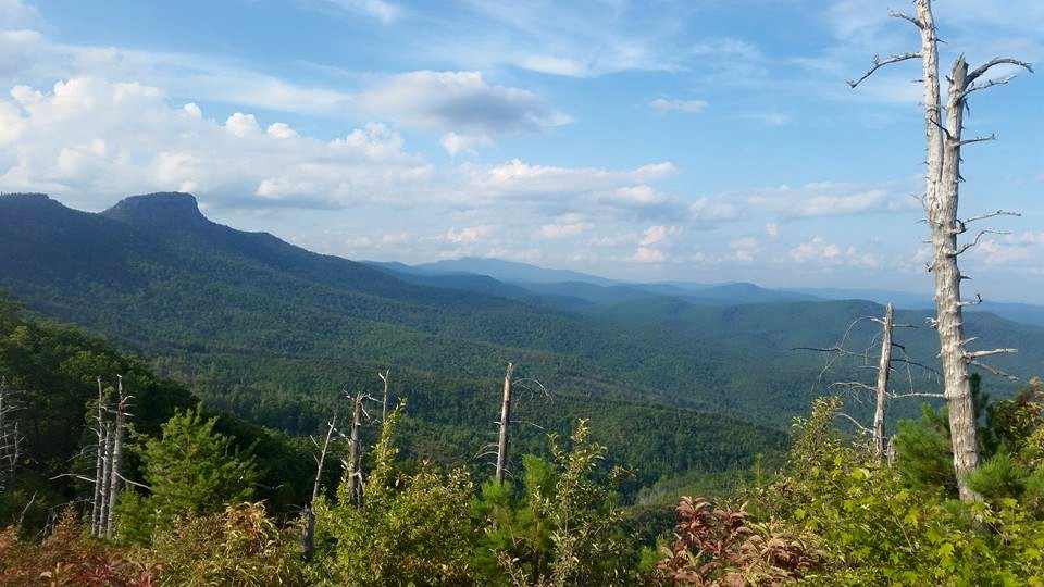
| The Chimneys and Table Rock as I head further down the MST. |
 |
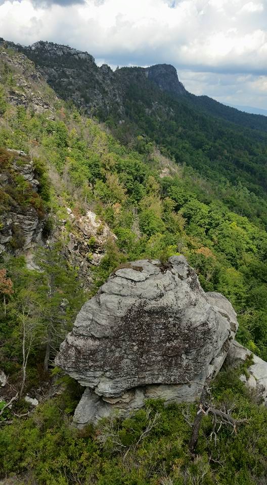
| The insane terrain of the Linville Gorge. |
 |
| Table Rock as I begin the climb to Shortoff. |
Thankfully, I had brought my hiking stick that Uncle Jim had made for me. It's lightweight and I leaned heavily on it to save my legs. After about fifteen minutes, I emerged in a tangle of dead trees and small boulders. To my right I could see that I was once again close to the rim of the gorge. Having some flat trail beneath my feet restored my confidence and I easily strolled along the shrubs taking the small side trails out to the edge of the gorge for views and picture opportunities. Table Rock was now a tiny speck and I carefully scooted to the edge of the cliffs to see several hundred foot drops beneath me. It was on one of these detours I witnessed a rare sight. A rain shower was sweeping down the gorge in my direction. I could see the top of the clouds and the defined streams of water causing steam to rise from the humid forest floor below. I unpacked my camera and fired away and snapped a few with my cell phone for good measure, I'm still kicking myself for not using the Gopro. I really didn't want to get soaked but I hoped that if it did reach me it would at least cool me off a little. It was here that I also was stuck with an idea that possibly saved my life. I noticed potholes worn in the rock from years of weather and some of them were deep and even had water standing in them already. I cleaned some of the deepest ones out hoping for some fresh rain and maybe a way to filter water on my return hike. Now, the weather just had to help me out.
 |
| The devastation from fire as the trail winds toward Shortoff. |
 |
| The size of this boulder can not be scaled. It's a monster. |
The trail stays level and I continued a nice pace. With all the hiking I've done, I've become good at measuring distance and knew I was closing in on the pond of Shortoff Mountain. The water I was now drinking from my shoulder pack was nice and cold from the insulated bottle and I couldn't help but take an extra sip here and there. Soon I could feel that I had about half of it remaining and forced myself to hold onto it until I refilled at the pond. Just ahead, I spotted a large brown circle with tall grass growing around it. My heart sunk as the realization hit me, this was the pond on Shortoff. As I leveled alongside the pond I found the spot where every picture I had seen of it was took from and as I stood there myself, I stared blankly at the bone dry hole where it belonged. I walked onto the dirt and found it firm beneath my feet, it had obviously been dry for a long time. I snapped a few cell phone pictures, brushed away more sweat, and headed down the trail looking for the spring tree. The rock climbers had gave me directions and I found the side trail leading downhill at a sharp clip. In a few minutes, I noticed a worn spot surrounding a tree and as fate and a dry summer would have it, the spring tree was dry as well. I was now almost six miles away from my truck with half a liter of water and temperatures near 90 degrees, I was truly in deep trouble.
 |
| The dried pond on Shortoff Mountain. |
 |
| A view of the gorge from Shortoff. |
The climb back up to meet the main trail was misery. The physical aspect of dehydration was starting to manifest in the form of a headache and my legs were wobbly and I stumbled over rocks I felt I had cleared. I was worried but I had cell service and a way out if necessary as long as I stayed on top of the ridge. I alerted Amber of my troubles and told her I would stay in contact. When I reached the main trail the rain finally caught me. It wasn't the light rain that had shown up in my photographs earlier but an absolute cloudburst. I quickly found a pine tree to stash my camera bag at an angle I would hope keep it dry and I stepped out onto a large flat rock and my first good view of Lake James. I laid back on the rock letting the rain drench me and another idea popped into my head. I took off my hat and let it catch water. I then rang the water into my empty bottle. I continued to do it until the shower passed giving me half a bottle of disgustingly murky water. I examined it and vowed only to use it as a last resort. I looked down at my watch, it was now 3:45pm. I had almost four hours until dark, I could do this.
 |
| A gift from God. |
 |
| Picking up speed in my direction. |
 |
| The potholes saved me. |
The problem with a good view from Lake James is the downhill stretch it took to get there. I was now climbing back uphill and the rain shower that had cooled me had left sunny skies and humidity that was downright unbearable. I was so sluggish I decided to sit down and eat my Nutella to Go and use the remaining water I had to wash it down in the hopes of getting some energy. As I squeezed the last drop from the bottle, I stood knowing it was all grit from here on out. The trail now was a small stream and it was agony watching the muddy water wash away while I was so thirsty. I noticed some potholes had gathered some water and stuck my filter in them draining three different ones in rapid succession. The water was hot and filled with sediment but I was grateful for it. I continued hiking on staying alert looking for any pothole I could find and more water. I actually was making great time and finding water easier than I had imagined. When I got back to the two large potholes I had prepped I found them to be filled just as I had hoped. Even though I wasn't overly thirsty at this point I drank all the water I could from the both of them. I rested along the rim of the gorge and watched the tiny knob of Table Rock rising in the distance. Back on my feet my head was swimming and if I turned too quickly I would feel like my vision would continue on without me. I used the bathroom and my urine was dark orange showing how much water I was missing from my system. I stopped a short distance later and drained more potholes of their water including some with dead insects, I HAD to have water.
 |
| Storms from Shortoff Mountain and a view of Lake James. |
 |
| Cell phone shot of the dueling rain storms framing Lake James. |
 |
| Heading back. Still a long way to go. |
Clouds would occasionally shield me from the sun and I used the time to push as far as I could but my legs were shot. Even on level ground, I was a shell of what I normally was. I started the downhill grade back toward the saddle leaving my precious potholes and when the thirst came more than I could stand. I screwed my filter onto the bottle of water I had gathered with my hat. It was a disgusting thought to have to do it but it went down better than I thought it would. I hiked downhill for what felt like forever and suddenly and almost appearing out of nowhere I saw a person lying in the trail on a mat and beside them, a big full bottle of water. Had I lost my mind? As I got closer I could see other people down the trail along the sides and all of them had water bottles. I took the hiker by surprise laying in the trail since he was wearing headphones and I asked him for extra water. He stared at me and I had already decided I was going to kill him and take his water if he asked how tall I was. Again, I asked for water but he said nothing. I hiked down to the next group of hikers and asked them for water and they refused to speak as well. WHAT WAS HAPPENING? Finally, a person called out to me from the campsite in the saddle to come on down he had some water. From his accent I could tell he was foreign which explained why the other hikers hadn't spoke to me. Instead of giving me water, he pointed out a source trail which led to a creek downhill from their campsite. I was exhausted but I started off down the overgrown trail. It was only about a ten minute walk before I arrived at a small pool and a trickling stream aided by a laurel leaf fashioned as a spout. When I squatted down to fill the first bottle, the world went dark. I felt a breeze and then nothing. I had passed out alone and off trail.
 |
| So many ways to die. |
 |
| Drenched exhausted and the small peak in the distance is where my truck is parked. |
 |
| The tiny stream of water that saved me. |
I've passed out three times in my life. Once was after having blood drawn and the other was when I had pneumonia as a child. I remember both earlier times because the breeze sensation was in reality my body tearing through the air to impact with the ground. When I rejoined the world from my third and most recent loss of consciousness, I was face down with a shoulder in the edge of the creek. I splashed water on myself and rolled over to lay back and gather myself. I barely had the sense to get my bottle filled and struggled getting my filter on top of it. The first few sips may be the best water that I've ever had in my life. The creek water was cold and it caused such a shock to my system that my head hurt instantly. My stomach was queasy and I ripped open a pack of crackers eating and drinking while resting my head on my pack. After drinking a full liter I closed my eyes and gave my body time to recover for a few minutes hoping the crackers and water would be enough to get me out of my predicament.
 |
| Sunset from the Chimneys. |
 |
| Daylight fades over the Linville Gorge. |
When I got to my feet, I didn't feel good but I was up and moving. I now was mad at the trail and I would have my revenge. I climbed up meeting the main trail and thanking the man who had undoubtedly saved my life. I still had about a mile and a half climb to the Chimneys and I struggled badly taking almost two hours to make it to the top of the mountain. When I reached level ground I laid in the middle of the trail; ecstatic that it was over. In reality, the hike wasn't over but I knew I could make it back to my truck. The sun was starting to set over the gorge and I found a perfect ledge to watch the sky light up as it dropped behind the ridges. I continued to drink water and found I had more strength. I looked through my camera and could hear people talking a few rocks over as they also watched the sunset. Usually I'm annoyed by other people but on this day I found their presence to be pleasant. Walking back in the dark I was so thankful that I was getting to go home. Amber had buzzed my phone all evening and I had reassured her even though I was scared. When I passed a campsite full of people surrounding a nice fire I waved and moved on. A few minutes later I could hear people talking in Table Rock's parking lot and I knew I had truly made it! My smile was wide as I entered the last empty campsite and my phone buzzed again from Amber, at the moment I reached for it my mind was blown.........
A full grown black bear jumped into the trail in front of me freezing me in my tracks. The bear stood still watching me before walking casually off the trail and out of sight behind some trees. I walked slowly and slightly wide of the trees hoping it had went under the bank. Aside from the bugs singing in perfect harmony the night was silent. As I stepped around the opposite side of the tree, the bear was there--standing holding onto the tree almost peeking around to see me---I almost shit my pants. I was too scared to make noise, I don't think I even took a breath. I now was walking backwards as the bear stepped down onto all fours when behind me I heard a second bear. I stood between two black bears with nothing but a walking stick to protect myself, I was dead. My mind took control of my legs and I continued to back peddle. The first bear walked back across the trail and joined the bear hidden by the dark by foraging through the campsite's fire pit. I stepped into the parking lot and told the people of the bears up the trail and tossed my pack and stick into the bed of the truck. When I settled into the seat I wanted to just go to sleep for the night but I still had the long drive home ahead of me.
 |
| Table Rock parking lot as I arrived from my encounter with the bears. |
Once I made it off the mountain and back to civilization, I was starving and craving something besides water to drink. I stopped into a Dollar General as they were preparing to close and grabbed three Gatorades and a couple of candy bars. When I laid them on the counter I caught the cashier just staring back at me. She started to speak and I cut her off, "I'm 7'4". She smiled and said, "Well, I was wondering that too, but did you know you're bleeding from your forehead down to your chin?" Thanks for the memories, Linville. Until next time, happy trails.