Please note: the state of North Carolina often identifies bodies of water as rivers that most of us in East Tennessee and Southwest Virginia would call a creek. Hopefully this eliminates confusion if I switch back and forth in the blog describing the Catawba "River".
 |
| Old Dam on the Catawba River |
 |
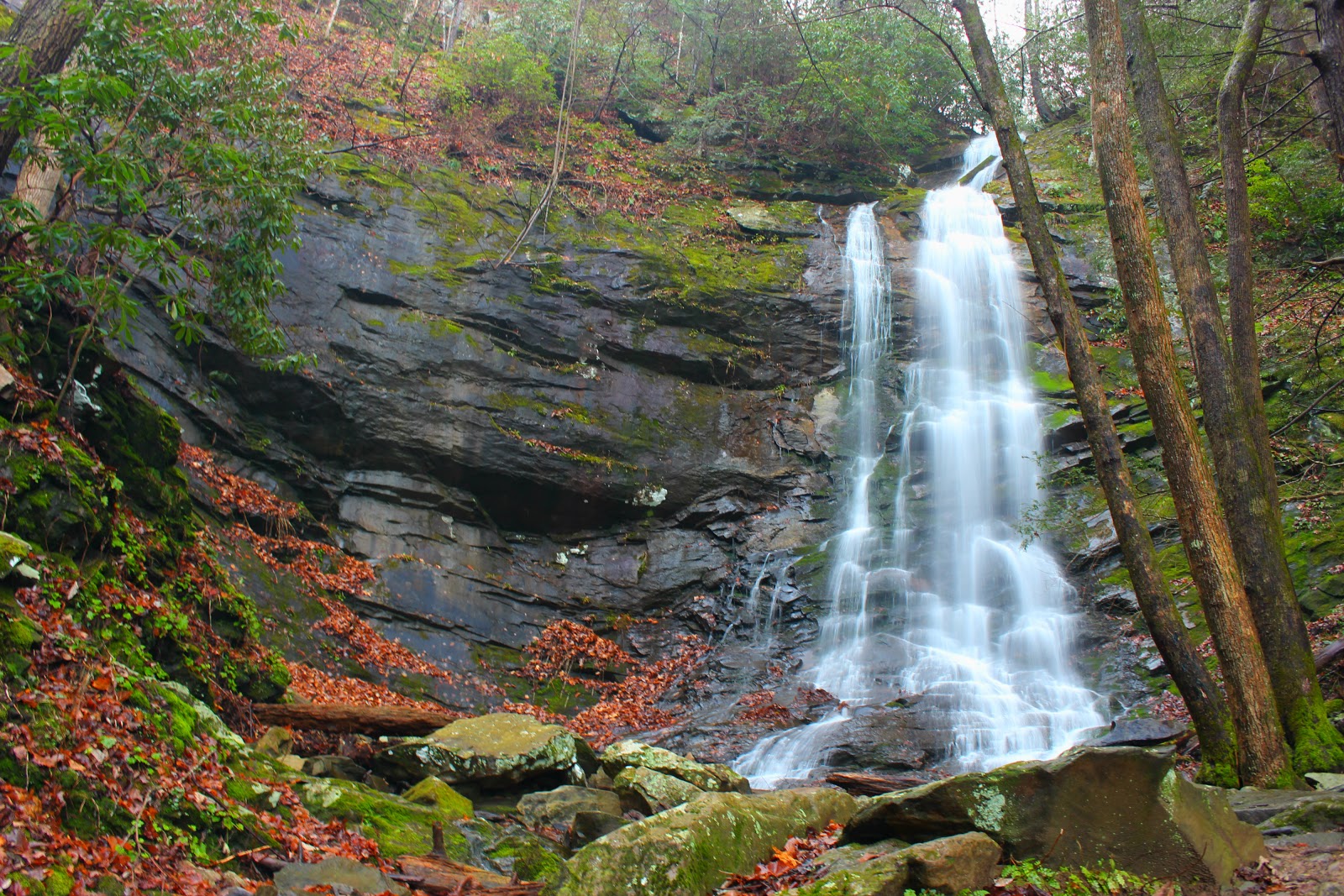
| Catawba Falls |
A couple of years ago, a visit to Catawba Falls could find you face to face with an angry property owner and a loaded gun. Fast forward to 2010, the tract of land housing the falls went on the market and luckily the North Carolina Foothills Conservancy ponied up enough cash to secure the land for use of future generations. I hadn't put a lot of thought into visiting the area because the pictures I had seen weren't that impressive and Catawba Falls is rather isolated compared to other waterfall hotbeds in the state. I also had read the most beautiful of the falls required a dangerous climb up and around the massive 100ft main drop and then another thirty minute climb into the mountains.
 |
| beginning of trail to upper falls |
 |
| Steve heading up |
 |
| The rope climb |
Enter Steve, each time we hike I purposely pick out a difficult one. We keep a similar pace and have a similar personality as well (those that know us just shook in fear) Last week we knocked Bradley Falls off our list of Carolina Falls and I chose to visit Catawba this week just to keep us from going soft. I didn't anticipate any problems but as we neared the town of Old Fort the rain grew heavy and quickly cleared by the time we arrived at the trail head, but the damage was done. The trail was now soaked and the wet leaves added to my concern. The trail stays level during the majority of the hike and slightly gains elevation before arriving at an old dam that was once used to harness the power of the Catawba River. I thought this area was really neat and the forest had done it's best to reclaim the surrounding buildings and the river had bored through the dam over time. From there the trail kind of vanishes and winds through and around downed trees and across small side streams. It widens again right before the base of Catawba Falls. My first reaction was WOW!!! It's one of those waterfalls you just need to see in person. The water cascades from as far as the eye can see and the river vanishes high at the top of the mountain as it bends to the right. My amazement of the first falls had not completely clouded my judgement. I started eyeballing the trail on the right side of the falls and noticed it was steep, slick and long. I hated to break the news to Steve, he thought we were done, but I told him there's a nicer one above this, and we just had to climb over this falls to get there, his shoulders slumped and he took the lead on the climb up the cliff.
 |
| section of main falls on the climb up |
 |
| up and over or down and dirty? |
The people who maintain the trail must have laid down their chainsaws and machete's and said "screw it" because our trail was now a scramble, using any root or tree branch to pull ourselves up and over obstacles. The climb reminded me of the Red Fork Falls area in Erwin, Tennessee but on a larger scale. A few places along the climb you could literally step over onto the waterfall and take photos of different sections of the falls. The trail gains some serious elevation and as I crawled under a log and rose to feet I saw Steve sizing up a rock face with a rope dangling to where we stood. I pulled on the rope and noticed it had professional anchor pins from rock climbers holding it at the top of the cliff. I leaned my weight against it and it held, so I began to climb the wall. I never imagined rock climbing and using ropes when I began hiking but now I'm at ease with such obstacles, we both made the climb quickly and easily. As we turned up trail, I looked back dreading the hike down but pushed onward. Steve had vanished over a large rise and yet another downed tree and said, "good news, more treachery!" The trail swings wide around a protruding rock face and is now high above the river, it's a narrow squeeze around the rock but the trail then swings away and up even further from the river. Once it levels, it's a nice narrow path framed in mountain laurel, the trail slowly declines to creek level and through the trees we could see Upper Catawba Falls. They were definitely more beautiful than the first one, crashing 60 feet over a rock ledge and then cascading around and over a protruding boulder at the base. I was pretty gassed so we took our break there marveling at the size of the falls and admiring the nice view of the Catawba River valley downstream. During our climb I hadn't realized truly how high we had made it but I could now see distant mountain ranges and hear the lower falls although faint in the distance.
 |
| what's that through the trees? |
 |
| Upper Catawba Falls |
 |
| my favorite shot of the day |
After a memory card full of photos and some hearty laughs, we began the hike out. We both dreaded the descent around the main falls but we made it faster and easier than we anticipated. I felt a sense of relief when I could look back from where we had came, and we made our way down the trail to the old dam so we could explore around the base of that falls. As we made our way down the trail we encountered an older couple huffing and puffing their way up the mountain, they asked us how far they had to go and I showed them some of our pictures. We said our goodbyes and Steve started laughing aloud, "I didn't have the heart to tell them they would never make it." Until next time..happy trails.
 |
| what goes down... |
 |
| must come up |
 |
| waterfall below the dam |