Thursday, February 28, 2013

Sometimes it hard to tell which is better, the journey or the destination. Today was one of those instances as Steve and I set out to find the elusive Dick Creek Falls. The information I could gather online was limited and varied on routes to get to the falls so we both were a little skeptical we would even find it. The only route that didn't involve crossing private property began at Rock Creek Park in Erwin, TN.
Rattlesnake Ridge
First sight of Dick Creek

I have visited Rock Creek numerous times and hiked to the falls on there, which is not an easy hike in it's own right. We arrived at the parking area around 10am and began the hike by waking to the far end of the camping area (the road is closed in winter) At the end of the camping area near camping loop C, the trail head for Rock Creek Falls begins, a short distance further a trail breaks to the left labeled Rattlesnake Ridge and crosses Rock Creek on a wooden bridge. The first part of this trail is pleasant and crosses back and forth across a small stream, when the trail leaves the stream it enters a part of the park that has had a prescribed burn and the forest is decimated. The trail climbs sharply up Rattlesnake ridge and I could feel the burn in my legs and the burn in my lungs as I gasped for air. The trail stays steep for the next mile and gains almost 900 feet of elevation! Eventually the elevation levels off at the top of the ridge and you enter a large clearing with several intersecting paths and roads. To the left and going uphill is a forest road labeled Dark Hollow, to the right is the continuation of Rattlesnake Ridge trail and straight across the clearing is a forest road going downhill which is the road to take to continue to Dick Creek Falls.
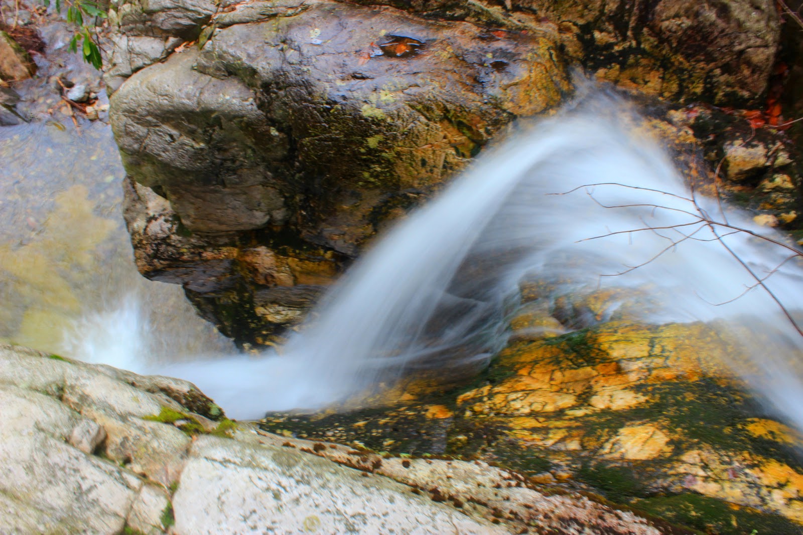
Dick Creek Falls
Further downstream
nature's high dive.
Steve really was tempted to get in.

 It was a welcome change hiking downhill after that brutal climb and within a few minutes we passed another forest road that turned sharply to the right DO NOT take this but stay on main road. The road continues downhill for about a mile and arrives at Dick Creek at a small cascade created by an old log wedged in the creek. Rock hop the creek and stay on the road until you come to a forest road on your right within 50 yards or so. The road looks like it has seen some vehicle traffic and it's flat and easy to follow. You will be heading upstream on Dick's Creek at this point. It's about half a mile up this road until you will look for an opening on the right leading to a campsite, it was fairly obvious to us and someone had even tied hot pink flagging tape in a tree indicating we were in the right spot. After a stroll through a large campsite, the roar of Dick Creek Falls drowns out the conversation. I rushed over to the edge of the creek and looked over the cliff to see the deepest green pool I have seen next to Devil's Bathtub, or Midnight Hole. The falls is located in a grotto setting, and drops about 25 feet into the deep pool. Even though the falls isn't big it may be the most beautiful I've visited in East Tennessee. The rock cliffs are colorful and there really isn't a bad place to take a photo. We got our snacks out and set by the pool and tried to guess at it's depth. My guess was anywhere from 25-30 feet deep at it's center, and we both agreed we would back in the summer to find out for sure. After exploring the area above the falls we made our way out to the main logging road again.
Logging road next to Dick Creek...easy hiking.
Trees like this are trail markers for old school hikers.
Climbing down to get to the main part of Upper Dick Creek Falls

Upper Dick Creek Falls
Of all the waterfalls I've researched hiking to, Upper Dick Creek Falls seems to be the most difficult for people to find. Once you get back on the main logging road at the lower falls, continue on the logging road still heading upstream. The road will go through a clearing but just walk straight across to the far side and the road continues on upstream. A short distance further, the road comes to another crossing of Dick's Creek. We were able to cross without getting our feet wet and once across we were in a campsite with a large fire circle. An obvious trail is straight across the fire circle and enters the forest away from the creek. DO NOT TAKE IT, instead look for a faint trail to the left next to the creek. We just waded into the laurel and within a few paces could see a makeshift path still heading upstream. The forest opens up and the hiking is easy we stayed within earshot of the creek but were at varying distances away from it. The creek has several loud cascades that we couldn't see through the laurels but we continued walking in the open forest and the trail will eventually begin climbing away from the creek and cross an old logging road, once again this was pretty obvious even though lots of laurel was growing in the road. Turn left on the logging road (still upstream) and a short distance later you will see the falls.
Upper Dick Creek Falls
just across the creek on the right side of the falls.
some of the rocks that collapsed along the falls.
corkscrew at the top of the falls.
this would be a fun ride, until you hit the bottom.

This is a very unique waterfall as it's like getting four waterfalls in one. Each drop can be photoed individually or as a group. The height is impressive too, the pictures I had seen make it seem much smaller but I would say it's at least a 35ft drop. The area has seen some major changes and it seem to have happened within the last 100 years. A large rock shelf in front of the falls collapsed and created the four drops you see now, the large boulders are tough to negotiate and the falls sit down in a semicircle sinkhole. We climbed down from the left side of the falls and crossed the creek and found a cranny in the boulders to climb to the top of the falls. The main drop of the falls has an awesome corkscrew as it shoots through the crack in the rock. There is also a nice little pool at the top of the falls but a laurel has been uprooted and lays in the majority of it. The next time I visit, I will be sure to bring the trusty Sears & Roebuck handsaw to clean up the shots a little. So if your in the woods and pass a giant wearing Hawaiian swimming trunks and carrying a handsaw, you will know it's me on my way to Dick Creek. Until next time...happy trails!
tell 'em I can hear 'em!
heading down Rattlesnake Ridge into Rock Creek Park.

Sunday, February 24, 2013

After a trip through the Cullasaja River Gorge, our next stop was the Glen Falls scenic area just off highway 64 in Highlands. Glen Falls cascades down over 200ft in three separate drops. The trail begins at the top of the mountain and descends along the falls with a well maintained trail including wooden steps. There are several areas that you can access the falls and go out onto viewing decks for closer inspection, many people can't resist the urge to get even closer as evident in the worn path around the railings. Several people have been seriously injured falling in the water and being swept over the falls here, so watch your step if you want that really good picture across the creek!
Glen Falls
Upper drop of Glen Falls 70ft
middle drop of Glen Falls 90ft
Kip next to the middle drop gives an idea of the size of the falls
 Secret Falls made the list at the last minute and turned out to be the highlight of the day for me. The trail head is on the opposite side of town from where we were and just off Walking Stick Road. Main street in Highlands turns into Horse Cove Road just outside of town and begins a wicked descent along a sheer rock cliff, I enjoyed the road and was jealous of all the people who had houses with such incredible views. Walking Stick Rd was gravel and in really rough shape, but featured several half a million dollar homes including one built just above Walking Stick Falls. The road descends gradually and eventually fords a creek just before the road forks and you arrive at the trail head. We followed a gated forest road before taking the Big Shoals Trail off to our left. The trail winds across a ridge line with no sound or sight of water, we joked as to why the falls got it's name. Eventually the trails winds around the ridge and descends to a small branch. The water was low so I thought we were in for disappointment, in a few yard we crossed yet another stream this one with a larger flow and huge log bridge crossing it. The trail climbs away from the creeks before taking a sharp downhill turn and the sound of roaring water in the distance could be heard. As we closed in on the falls I was surprised at how loud it was! I rushed ahead of Kip and Steve and was the first to see Secret Falls, it's absolutely wonderful. Located in a small cove with a sandy beach along the creek,  a deep green pool below the main drop, and a four foot creek wide drop just downstream, I was in love with this waterfall. My excitement almost got the better of me as I got tangled in some laurel and almost baptized myself head first in the stream.
Secret Falls 50ft
Downstream from Secret Falls
above the water shelf looking downstream
As daylight faded, we had time for one last stop and maybe we saved the best for last. Whitewater falls is located in Jackson County just across the Transylvania County line is one of the most visited waterfalls in North Carolina, and with good reason, it towers over most other waterfalls at 411ft. I have been several times to Whitewater and I never get tired of going back. The falls is located across a massive gorge but can be easily viewed from the platform the park service has constructed along the gorge wall. One day I will hike to the base and visit the equally impressive Laurel Falls at over 400 ft high! Steve moaned and groaned at the over 100 steps that took us to the viewing platform but it was worth the pain once he got there. As dusk was settling in, the falls were lit perfectly for photos and I took advantage, Enjoy the pictures and until next time...happy trails!
Whitewater Falls
Lake Jocasse in the distance
riding around Whiteside Mountain
frozen double waterfalls on Whiteside Mountain

Saturday, February 23, 2013

North Carolina is home to some of the finest waterfalls in the country. Some can be seen from the comfort of the car (Looking Glass Falls) while others require sweat, determination, and maybe even a few blisters (Bradley Falls) but it's almost baffling to think that one in particular can be DROVE underneath! US 64 West of Highlands travels through the Cullasaja River Gorge. On the first stretch of this road, the dream of driving behind a waterfall can become a reality. Bridal Veil Falls is right next to the road and the park service has paved a loop behind the falls wide enough for two cars to pass! Yesterday, Steve, Kip, and I decided to hike in the Highlands area in celebration of the rare occasion of us all three being off on the same day. Misty was kind enough to loan us her jeep and we set off early with a notepad full of waterfalls and directions scribbled down.

It's a scenic drive winding through the mountains near Cashiers, North Carolina. There are many nice houses built along the cliffs and mountain tops and golf courses are a dime a dozen. I was more interested in the huge rock faced mountains and distant views of lakes as we wound toward Highlands. When 64 turns west out of downtown Highlands, I suggest you buckle your seat belt and say a prayer because the road turns gnarly and narrow as it passes through the Cullasaja River Gorge. The first stop of our day was Bridal Veil, I was pleased with the flow and the icicles along the edge of the falls were very photo friendly. Unfortunately the road behind the falls was closed due to the ice covering the roadway. We were still able to park and get some good pictures so I was satisfied.
Bridal Veil Falls
and another angle
Just a mile or so down the road, Dry Falls Scenic Area is on the left side of the road. Dry Falls has one of the strangest names considering it's flow is downright massive. It's also a unique waterfall in the fact that you can walk behind the falls. The park service has done an incredible job with the sidewalks, railings, and even have built a ramp so that handicapped people can enjoy the waterfall also, so kudos to them! Once again ice was present all around the falls and the area behind them was gated because of the ice, however it did little to hinder us, we jumped the gate and continued on much to the envy of the less nimble visitors there with us. The mist from the base was blowing up high in the gorge and a rainbow could be seen with the naked eye, but not picked up on camera which was a slight bummer. I've always wanted to hike to the base, but with all the ice we decided not to try our luck and continued back up to the parking lot and onto the next stop.
Dry Falls
closer view near the gate
Steve and the ice covering the railing along the falls
behind the falls
far side of the waterfall
looking down the Cullasaja Gorge
After leaving Dry Falls, the road continues to follow the river through the gorge, only a few miles later the river begins to lose elevation at a rapid pace and becomes further and further away from the road level. Warning signs begin to appear cautioning of narrowing roadways and 10mph curves, over the next two miles highway 64 is one of the more terrifying roads in America. At the top of Cullasaja Falls the road is blasted through the cliffs on one side and sheer drops of hundreds of feet on the other. All three of us remained silent on this stretch and breathed a sigh of relief as we passed a sign indicating we were leaving the river gorge. We found a good spot to turn around and headed back up 64 to a narrow pull off along the massive 250ft high Cullasaja Falls. The road side view here is probably the best option even though there is a trail to the base, the upper section wouldn't be visible from down there so we didn't go, plus it was almost a completely vertical trail half a mile or more down. Here's a quick look at the majority of the falls.
road side at Cullasaja Falls
US64 above Cullasaja Gorge
 To be continued in another post...happy trails!

Wednesday, February 13, 2013

Recently I discovered the Hawksbill Mountain and Table Rock area hiking trails while thumbing through some new books I purchased. My initial trip to Hawksbill led to several discoveries. First, North Carolina doesn't believe in using gravel on their roads, Table Rock is gated in the winter, and Hawksbill Mountain is one of the most wonderful places I've ever hiked.
Amber's back on the trail!

Linville Gorge behind me.
Table Rock to the left and Shortoff in the gorge (center)
Amber at the summit!

When the chance to actually hike with my wife and our friend, Misty arrived I knew that they would love the mountain as much as me. The morning of the hike we almost decided on hiking to Grandfather Mountain but after calling only to find out all trails were closed, I made the decision for them, we would tackle the Hawk. The trail head is just a mile from the mountain's summit, but it gains some serious elevation in between. I hike so often that I had to stop several times on my way up to wait on the girls to catch up. Being a weekend day, the trail was crowded with fellow hikers but most appeared to be back packers who were hiking out as we made our way up the mountain. The final stretch of trail is rutted badly and pretty much straight up. The water that had drained across the rocks was frozen so we had to watch our step. When the trail levels, it is at one of the better campsites in all of North Carolina. To the left is Table Rock Mountain, Shortoff Mountain, and views of the Linville Gorge, to the right is the summit of Hawksbill slightly obscured by the underbrush you have to hike through to get there. We chose to hike toward Table Rock and a downhill trail and avoid the crowd of trail workers gathered at the summit. I had found a sweet little rock outcrop nestled on the side of the gorge my last trip, and was delighted to see it was free for us to have our lunch along the gorges edge. Misty and Amber are both bigger daredevils than I, and took turns having their photos made dangerously close to the edge. I eventually gained a little nerve and also had my photo made looking over the Linville Gorge.
Misty always the "one upper"
I could have sat there all day.
One of my best friends.
My family.

After our break, I noticed the trail workers gathering the belongings at the top and we hiked on up so that we could dangle our feet off the edge and take some even more epic photos. We were joined by an older couple and they were full of information about the distant mountain ranges and even the "ugly ass" hotel that breaks the ridge line between Grandfather Mountain and the Roan Highlands. The weather was perfect and having Amber and Misty with me was a welcome change to my usual hiking. We all had our turns sitting on the large rock protruding from the mountain side and Cash took turns being held so that he wouldn't run off into oblivion. There really isn't a bad place for photos on the  whole mountain, I would recommend going and finding out for yourself and until next time... happy trails!
waterproofing for some waterfalling
crossing the top of Upper Creek Falls
Upper Creek Falls (100ft)