Tuesday, July 31, 2012

near the entrance to the Sand Cave

The Sand Cave and White Rocks overlook are conveniently located only a mile apart in Ewing, Va. The only problem with their location is it requires a strenuous four mile hike to the top of the mountain to enjoy them. The trail head starts at the base of the mountain in Thomas Walker Civil Park and follows an old logging road up the mountain. The trail is wide and easy to follow, and the switchbacks take a little of the strain off your legs. After a few minutes of hiking, you arrive at a trail registry and I was pleased to see that there were only a few people ahead of Amber and I, especially since it was a Sunday. From there the trail climbs steeply up a dried up creek bed for about half a mile and finally levels off and begins the switchbacks on up the mountain.
The picture doesn't do this place justice, it's massive!
Amber dwarfed inside the cave
Far left side of the cave

As elevation is slowly gained, the valleys and towns of Ewing and Rose Hill can be seen through the trees. There are several rocks along the trail for good resting spots and Amber and I took advantage of them, we brought Cash, our dog with us and we stopped occasionally to let him rest and drink water due to the afternoon heat. He seemed no worse for the wear and practically pulled Amber up the mountain at times. About an hour had passed, and we arrived at a sign for the White Rocks overlook spur trail, the trail here rises dramatically for almost a mile to the overlook, to save our legs I continued on the main trail for another mile (this is the horse trail) and crossed over the mountain and began the descent to the sand cave. The vegetation on the mountain changes significantly on the Kentucky side of the mountain. Ferns and Mountain Laurel begin to spring up everywhere, and as you draw closer to the cave you can hear a mountain stream falling from a high elevation. When the trail finally levels before the sand cave there are white pebbles and sand literally everywhere and as you round the corner a waterfall about fifty feet high greets you at the mouth of the massive sand cave.
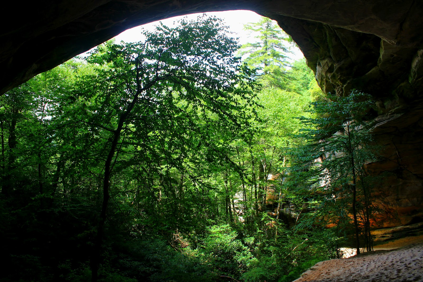
Tree growing with arch of cave
Pillars of pure sand formed from years of wind erosion

Amber was visibly impressed with the sheer size of the sand cave and the cool air generated here made it the perfect spot for lunch, our subs from subway really hit the spot after over four miles of downright grueling hiking. I rewarded Cash for his efforts with some chicken from my sub and Amber poured him a bowl of water. I never imagined that little dog would mean so much to me, but he is a good hiking buddy! The cave was formed over time by wind and water erosion, and the sand is deep and tiring to climb through to reach the back wall. I was surprised by how well Cash enjoyed running through the sand, he got covered! I thought I had found a good rock to sit on near the wall but it crumbled under my weight, just some wind worn sandstone. Amber and I spent a lot of time here resting and taking photos before heading out and up toward the White Rocks. At the trail head for sand cave (at the horse gate) a trail leaves to the left and is a much easier way to the overlook. It winds gently up the mountain and levels on the ridge line. The white rocks become visible and are somewhat intimidating, the first time I saw them I thought it would be impossible to climb them, but as the trail winds around behind the rock face, a crack in the rock is the trail to the top. There are plenty of roots to hold on to and even though it's really steep, it's a short trip to the top. As the trees clear you step out onto the bare rock and can see into the heavens. In the winter it's a 360 degree view and on a clear day, buildings in Knoxville, TN can be seen. The Kentucky side is mountain upon mountain with the occasional mountain top mining scar smearing the landscape. The sun had beat down on the rocks for over eight hours the day we arrived and you could literally see the heat rising off them. I sat down and emptied my shoes which were still full of sand, and Amber and Cash rested nearby.
nearing the top of White Rocks
looking off the top of White Rocks
Ewing, Virgina


Eventually the heat was downright annoying and we had to pack up and retreat to shade. The day was coming to a close and we had a long hike down. After an hour and a half of fast downhill hiking we staggered out of the woods and to the wonderful air conditioned truck.
Cash taking a water break
We deserve to relax!

The Ewing Trail is a beautiful place and the Sand Cave and White Rocks are an incredible one two punch for hiking enthusiasts, this is a can't miss if you find yourself in southwest Virginia. Take plenty of water and some food, and most importantly leave things as you found them! I run into so many beautiful places ruined by trash and graffiti, so please keep this natural wonder, well, wonderful, and until next time, happy trails.
Finally some level hiking!
under the falls, cooling off.
What's that smell?

Sunday, July 22, 2012

My wife eventually grew sick of me singing "Country Roads" by John Denver and committed to going hiking in West Virginia with me. I have been once before, but having her and a group of my friends made for an exciting day. The New River Gorge is a really impressive area with the world's largest single arch bridge spanning the gorge over 800ft above the river. Although named the New River, it is actually the second oldest in the world with only the Nile River being older. It's only a three hour drive to the gorge and traveling through two tunnels, beautiful scenery, and hilarious conversation, your there before you know it.
New River Gorge Bridge
Amber and I on the Fayetville Station Bridge
New River
from observation deck at Canyon Rim Visitor Center


Several weeks ago, a devastating storm blew through the area and when we arrived two weeks later, some facilities were still without power. It was extremely hot, and I was really looking forward to the drink in the visitor center but it was closed so we visited the overlook and continued down the gorge via a one lane road to Fayetville Station and crossed the New River on an older bridge that looked back toward the massive arch bridge. I was surprised at how the deep the river was and a set of rapids just downstream made me wish I had a raft with me, but gave me a reason to come back. We had to ditch my friends fancy sports car along the road because it kept dragging and pile in Misty's jeep, I really enjoyed watching my buddy fret over his car while we traveled through the gorge. We also visited Summerville Lake which is the source waters of the powerful Gawley River, which features class V rapids, and we were able to safely retrieve the sports car from the parking area, unscathed.
Lake Summerville
from Summerville dam

Afterwards, we set off in search of Cathedral Falls, which according to most websites is one of West Virginia's most photographed and beautiful waterfalls. When we got there however, the creek was completely dry and the only thing we found was a rock wall and where two other visitors had took the liberty of lightening their loads. The heat added to the aroma and I couldn't help but laugh at our waterfall bust. The trip to the waterfall wasn't a complete loss though, on our way we passed Hawk's Nest State Park and we stopped on our way back and it had some fine views of the New River Gorge. Here's a few pictures of our day in the wild and wonderful, hope you enjoy and happy trails!
Cathedral Falls (trickle)
view from Hawk's Nest
river bend at Hawk's Nest
Hydroelectric plant on New River just above Kawahna Falls

Monday, July 16, 2012

A day after my first road race, I awoke feeling surprisingly...ok. As with most Sunday's lately, I have dedicated my off day to hiking. My usual hiking partners also ran the race the night before so it took a little persuading to convince Steve and Pauline that hiking was the best way to spend our day. Eventually, they caved and we were off to Erwin, Tennessee; home of Rock Creek Recreation Area.
Rock Creek winding down the mountain
nice little 8ft drop.

Rock Creek is a really underrated area in my opinion, the main park is nice and has plenty of campsites, a playground, and even a nice swimming hole. What most people don't realize or take advantage of is the well maintained hiking trails, one of which leads to Rock Creek Falls. The trail to the falls leaves camping loop C and shortly thereafter enters the Unaka Mountain Wilderness. The trail although well maintained is also quite grueling, the two miles leading to the first falls is uphill the entire way and some stretches are steep, my thighs are still burning. There are several creek crossings and your feet will get wet, if they don't, turn around and leave because the falls are low and the hike isn't worth it. We arrived at a perfect time, after a heavy rainstorm. The water level was perfect too, my shoes were wet at each crossing and the cold water was a welcome feeling on my tired feet. As the trail gains elevation, so does the drops in the creek. Rock Creek is really photogenic lined with mountain laurel and many large boulders. Just before the first falls, the trail reaches it steepest incline but the reward is worth the effort with a beautiful sliding cascade of 40ft. Most peoples instincts would have them scrambling down the trail to it's base, but save your energy, just up the trail lies a 50ft multi-drop waterfall at the end of the trail. My first visit here I made the mistake of only stopping at the first falls thinking that was all that was there. There is also a nice 30ft waterfall between the two falls but getting to it is almost impossible, there is no trail leading to it's base, you can only reach it by climbing the 40ft cascade but after a rain the rocks provide zero traction.
2nd Falls on Rock Creek over 50ft high.
1st falls on Rock Creek, 40ft high
1st falls with creek as foreground.

If your in the need to quench your hiking thirst, then head down to Rock Creek. Take three bucks for the park entry fee, some water for the hike, and most definitely a camera. Until next time...happy trails!
nap time

Last Friday, Dad and I visited Giles County, Va for a hike up to the Cascades. The Cascades are by far Virginia's most popular waterfall, receiving 150,000 visitors a year and by paying a small $3 fee you can see them too (I'd pay $30). Located on Little Stoney Creek, the falls are at the head of a two mile gorge.
The Cascades

Recently, Dad had a stay in the hospital and this was his first trip hiking since, I was a little concerned that he wouldn't be able to make the four mile trip. When we arrived at the park we looked over the information board and noticed two trails followed the creek one being labeled upper and the other lower. Dad had asked a lady at the gas station about which trail to take and we headed out on the gravel path labeled upper. The trail briefly follows the creek bed before turning  away and steadily increasing in elevation. Several benches are along the trail for rest stops but dad and I plugged along without stopping. He talked about his years with the phone company and climbing steep hills with a tool belt and a ladder during hot summer days, he also could identify every tree along the journey, and had tips to help me remember them in the future. Eventually we passed a family coming out and they told us we were within half a mile! I was excited for dad because he had persevered and now was going to make it to the falls. We had one more steep climb that took us past some impressive rock formations before the trail leveled at a camp site and split off to either the base or side observation platform. Dad and I hiked down toward the base across natural rock steps and my excitement in hearing the falls caused me to leave dad behind momentarily. Eventually we both made it to the base and surprisingly were the only ones there. The weather had been really kind to us, it had rained all day until we got there and we were dry all the way to the falls with the exception of our sweat.
Long wooden bridge across Little Stoney
Dad below a huge rock formation
Roaring cascades on Stoney..
..and more

I took a lot of photos here because there are so many angles and options from a photography standpoint. The overcast cloudy day made conditions perfect for taking pictures of water. The observation decks are nice and well constructed and the drain pool looks deep and refreshing, a major rock slide just downstream from the falls, reminds you of the danger and remote setting. We took our photo's and set out on the hike back, at the trail intersection I sent dad back the way we had came in and I took the lower trail that followed the creek and was far more challenging. I was glad I had saved hiking this section until after I had seen the falls, it was downright awful in places. However, the beauty of Stoney Creek was on full display, there are many cascades downstream that could qualify as named waterfalls, and scars from a massive flood in '96 are visible in the form of rotten tree's washed along the banks.
Dad at the falls
Rock slide blocking Stoney Creek
Real Stairway to Heaven

I have seen far more impressive waterfalls than the Cascades but if you include the lower trail hike up Little Stoney Creek, this one ranks pretty high. I can think of no better way to spend three dollars than to take a hike up to the Cascades. It was a great day and even better having dad along and talking and laughing the whole way. Our ride home down the parkway was somewhat of a bust with the rain returning but with the recent drought we couldn't complain. I'm sorry I've been so behind with updates but between training at work and training for a race that hasn't left me with much free time, but I have been getting back on the trail and off the track, so see you soon...happy trails.