Sunday, June 22, 2014

I first became part of what is now affectionately known as the Power Tripping Trio a few months ago. I had been asked to help lead some group hikes in a fund raising effort for the Juvenile Diabetes Research Foundation, and what first started as large groups of hikers on our trips, the numbers quickly dwindled until the truly dedicated were revealed.

 Almost a year ago, I was working an unusual early shift and decided the skies were right for a evening hike to Roan Mountain to see the sunset. The rhododendron were in bloom and I knew the perfect spot to hike to see both them and the sunset, Jane Bald. As I crossed into the opening of the large rocks on Jane I was dismayed to see two other photographers in "my" spot. An older gentleman was higher up on the ridge and a young girl was settled slightly to his side with a tripod set up as well. At the time, I wasn't aware of proper trail etiquette and plopped down under the large boulder protruding  from the bald...directly in their shot.
Jane Bald sunset. One year ago. Site of the infamous photo bombing.

Steve, Amber, and I laughed and told stories as we watched the sky lower from the heavens and we eventually started making small talk with the female photographer named Halley. She was from North Carolina, so I was immediately jealous of all of the prime hiking real estate that was in her backyard. Considering I was messing up what would be a dream shot for her, she was friendly and when I arrived home that night I received a friend request on social media. I poured through her photos and marveled at her travels and talents behind a lens. She also ran a photography page called Appalachian Exposures and some of the images there were the best I had ever seen. A friendship blossomed, and we kept track of each others adventures through our facebook pages.

In December of last year, I was reassigned to a store in Church Hill, Tennessee. It was reunion with one of my childhood friends, Ray Hayes and the eventual introduction to the final member of the trio. In his spare time, Ray plays in a softball league in Kingsport and the coach of his team is an avid hiker as well. I would go into work and tell of my grand adventures on the trail and it seems that each time I was met with the same response from Ray, "My buddy Forbes has been there."
John on our first trip to White Rocks and Sand Cave.

I finally met John Forbes on our first group hike for JDRF to the Sand Cave in Ewing, Virginia. Also joining us at the last minute for the day was Halley Burleson and her trail companion, Sallie Gator the dog. John and I walked together much of the day and his attitude and story telling ability kept my mind off of the burning legs underneath me. Before we were halfway up the mountain, he was already planning our next hiking trip, I immediately liked him.  In all, 15 people hiked the 10 miles to the Sand Cave and White Rocks and our group mixed and mingled all day, with everyone seemingly having a good time. As we arrived back at the trail head, Halley asked where else she could hike that day. I'm unsure what my facial expression was but I was impressed that someone had that kind of desire after a tough day on the trail!

The next trip for JDRF was to the Devil's Bathtub, and our numbers actually grew somewhat to 17 people. Once again John and Halley were front and center for the hike and when got to the tub, they were one of the few people that had the nerve or lack of sense to take the plunge in the freezing water. By the time, we started planning another trip, excuses and responsibilities took their toll and I decided our fundraising efforts for JDRF were sufficient. Although the group hiking was fading, I had made some powerful connections and soon we were back on the trail comparing notes and making plans for trips that most people wouldn't do in a years worth of hiking.
Sallie Gator was cold just watching Halley taking the plunge at Devil's Bathtub!

Some of our recent trips have been my fondest memories on the trail. I've been blessed to meet people who enjoy the outdoors as much as myself and their attitudes help feed my drive to keep walking even when my legs are far past their limits. Stay tuned as we already have several epic trips booked and my first EVER camping trip! Until next time, happy trails!
As you can see, we know how to have a good time!

Thursday, June 19, 2014

Eight waterfalls down and munching on peanut butter sandwiches, Jeff, Larry, and I were off to a great start on our mission to see 30 waterfalls in one day. It was only shortly after 1pm when we reached the Blue Ridge Parkway and a short drive later we were at our next destination, Skinny Dip Falls.
Skinny Dip Falls.
Tree on the Mountains to Sea Trail.

Skinny Dip Falls is insanely popular with both tourists and the locals so I wasn't surprised to see the parking lot at the Looking Glass Overlook jammed with cars. I still held on to hope that maybe I could get some decent shots of the falls since it was one of the more photogenic locations we were going to see that day. As we hiked the trail down the mountain we passed several groups leaving and when the falls came into view I didn't see another soul! My excitement was quickly squashed when I saw a lady sitting on the lone rock in the deep pool below the falls reading a book. She barely glanced up as I had to sneak around the boulder she was on to take a few pics and maybe salvage something useful. I noticed the bridge downstream from the pool was a nice shot so I set the tripod up for my picture and suddenly her kid ran into the scene whipping his manhood out and proudly peeing in the pool under the bridge! I was already annoyed and now I was downright mad. Not only was she ruining my dream picture, she wasn't watching a child that could easily drown downstream before she could reach him. I don't understand people that go to these places acting like they own them. I show up and take my pictures and leave so that others can enjoy them as well. Despite the challenges I was met with, I got some decent pictures without any children in the frame and Jeff and Larry were having the time of their lives so I was happy for them.

Looking Glass Rock.
Our next few falls were the easiest hiking of the day because we didn't have to leave the car to see them. Currently the Graveyard Fields is closed for expanded parking and new restrooms but the two large waterfalls in the valley below can be seen from the parkway can be seen from the road. We stopped at both and zoomed them in as best we could and were on down the parkway to meet the intersection with NC 215.

Long views from near Graveyard Fields.    


Second Falls at Graveyard Fields.
NC 215 is home to a cluster of quality waterfalls that can pad anyone's day hiking numbers in a hurry. We turned on 215 toward Waynesville and within .4 miles arrived at the trail head for the two waterfalls in Middle Prong Wilderness. It was the first time for me to see these falls so I was eager to get to them and was out of the car before Jeff could get it in park. I took my guidebook with me and was thankful I did, since the trail was confusing and involved several creek crossings and winding through rhododendron thickets with limited views. Jeff and Larry caught up with me at a campsite and the three of us found some flagging tape to follow upstream to the base of the first waterfall. I quickly noticed a swirl at it's base, which is basically the current of water picking up sediment and dead leaves making a little whirlpool. I had seen some beautiful pictures of swirls at the base of waterfalls online so I set my camera for an exposure of 20 seconds and was thrilled to see I had captured one for myself. To me, the entire trip had been worth it just for that one image. The creek and waterfall weren't the most impressive I had ever seen and the flow seemed to be down compared to the pics I had seen that made me add it to the list but the adventure factor in getting to the falls made them worthwhile. To see the upper waterfall we had to climb a steep bank and continue upstream wading the creek until it reached the base of the falls. The upper falls was beautiful, having a deep channel carved at it's base that also made for some great photography. Although it was my first visit to the two falls, I knew I would come back!

Jeff and Larry in the Middle Prong Wilderness.

Upper waterfall in MPW.
On the trail.

A short drive further down 215 we arrived at the roadside parking for Wildcat Falls. The trail follows an old railroad bed and is easy as it snakes around the ridges. The actual waterfall runs under the road with the upper portion above the bridge and a continuation below it. I set my tripod up for a picture and Larry stepped in front bragging that I knew where all the good shots were. I waited for him to finish taking pics but he sat down and settled in before I could get the picture, he was a true master of photo bombing! I even took time to step back and sneak a picture of him lost in thought and I couldn't help but smile, someone loved hiking as much as I did.
Bubbling Branch Cascades.
Deep pool on Bubbling Branch. Rain began to fall during this picture and spotted the lens.

Further down the road we stopped at one of my favorite waterfalls, Bubbling Branch Cascades. You can see the waterfall from the road but  I had told Jeff and Larry we had to climb the rock beside the waterfall to fully appreciate it. The cascade drops some 60ft and has multiple swimming holes along the climb. At the top of the waterfall is a crystal clear pool with a rope swing, I don't think there are many more perfect spots in the mountains. I looked across the gorge to where we parked and Jeff's car seemed so small surrounded by the mountain landscape. I took my time getting back down the waterfall so I was sure to get all the pictures I wanted while Jeff and Larry rested at the base. I could tell the trails and our marathon day was starting to wear on them, and truthfully, it was wearing me down as well.
My first swirl at Middle Prong Wilderness.

The next stop would bag us three more nice waterfalls and bring our total to 19 waterfalls around 4pm! I had mentioned Wash Hollow Falls several times during our trip and gloated that no one was ever there, but as we pulled in to the trail head a vehicle from South Carolina greeted us. I thought they might be there to Sam's Branch Cascades, which you have to cross on the way to Wash Hollow, but once again, I found someone right in the way of my picture. As we approached the base of the waterfall a group of four people were sitting there smoking weed! Besides being in my way, they had two dogs that ran up the bank barking and growling at us. They ran up the bank assuring us they were harmless and quickly retreated back to their spot at the base. I hated to interrupt their party, but I wasn't too upset since they ruined my chance to shoot the waterfall. I also started having some camera problems as we hiked out with my display saying the camera couldn't read my memory card. As bad as I hated to admit it, I could see the 30 waterfall total slipping away.
Section of the waterfall on Sam's Branch. This is a huge stretch of waterfalls that the trail crosses.

I worked frantically on the camera as we approached the final stop of that side of 215 at the Waterfall on the West Fork of the Pigeon River. The waterfall is right beside the road and I stayed in the vehicle while Jeff and Larry took off to take a few close up pictures. I finally got my memory card to start reading again just as we started back up the mountain and down the final leg of our trip to meet highway 64. The skies had been heavy with clouds all day and I could tell that our luck was about to run out. We had 20 waterfalls under our belts and I thought if we were lucky we could get the final three at Living Waters Ministries before the skies burst open.

Considering the waterfalls at Living Waters are on private property and beside the road, there is something about them that seem so peaceful and serene. The owners allow people to hike there at their own risk and sadly several people have died there over the years. In one of the more unique scenes in North Carolina, two creeks meet and can be photographed as they form two distinctly different waterfalls. Mill Shoal Falls cascades next to a beautiful red cabin and Mill Shoal Falls takes a vertical plunge of around 25ft. I have never been able to get decent pictures of either of them because of lighting, forgetting my tripod, or just plain user error, but I was finally able for everything to come together to capture a wonderful picture as rain began to fall. The slight drizzle quickly turned to downpour as we ran down the trail to Bird Rock Falls and the final waterfall of the day. Larry and Jeff risked the slick rock and ran out to view the falls while I took shelter in the laurel from the rain. Hiking back out we all had smiles on our faces and laughed wildly at the downpour and our now soaked clothes.
Mill Shoal Falls and Cathedral Falls at Living Waters Ministries.
A successful day of hiking in the books. We took a moment to pose for a group shot. 23 waterfalls, 10 miles hiked, in 10 hours. I'll never forget it!

The greedy side of me would have loved to top the 30 waterfall total but having 23 quality waterfalls in one day was still an impressive accomplishment and I feel like my goal of showing Jeff and Larry a good time had been met. Larry noted on the drive home that his paper had 23 lines on it and we had filled each one! It was almost an omen that we were meant to see that many and call it a day. I've already laid out a plan to return later in the year and stay closer to the trail head to knock out the elusive 30 waterfalls in one day...until then, happy trails!

Saturday, June 14, 2014

I've had a lot of wonderful experiences on the trail but this year has been the best so far. I've been hiking with different groups of people on almost every outing and I've enjoyed myself so much, I once again find myself hopelessly behind on my blog entries. I was walking through my store the other morning when a moment of inspiration struck me in the form of one our vendors. He stopped me as I passed and asked if I had updated my blog lately and that he and his girlfriend had been reading all my previous entries and were anxious for more. I don't think he realized it, but it meant a lot to me that anyone would take time from their day to read about my adventures, so Marvin, this one is for you!
Waterfall on Cedar Rock Creek.

My hiking buddy Jeff Forrester recently took a vacation and asked that I join him on a hike with his friend Larry Gullette who was flying in from Oklahoma for the week. Jeff was determined to show Larry there were other locations besides the Great Smoky Mountains to do some hikes and I went to work immediately on what may be the ultimate North Carolina waterfall sampler. I poured through Kevin Adam's North Carolina waterfall guide and picked our trip based on distance, quality, and most importantly, variety. I've been hiking in North Carolina for several years and chose a loop of sorts that started us in Brevard and swung us up to the Blue Ridge Parkway and back down 215 meeting highway 64 again outside of Brevard. When I finished my list, I wasn't sure if I could even do it but 30 waterfalls were on the agenda and I had two eager partners waiting to give it a shot.
Slick Rock Falls.

The morning of the hike I awoke at 4:30am and made the hour and a half drive to Brevard meeting Jeff and Larry at the Walmart just before the 276/64 intersection. I found Larry standing in the middle of the parking lot brushing his teeth. It was only the second time I had ever met him in person with the first meeting being just long enough to show his friends back home how tall I was with a photo op. Larry happily greeted me and I ran in to pick up some bandages for some nagging blisters and we were on our way to our first stop of the day, waterfall on Cedar Rock Creek.

Only a short distance up 276, a left turn took us toward the Pisgah Center for Wildlife and we parked there for the trail head, putting us on our first hike before 8am! The trail skirts the main building and enters the woods across a paved bridge and picks up the Cat Gap Trail. It wasn't long into the hike before I realized that Adam's book listed the distance of the hikes for one way only, our mileage was doubled. I didn't want to break Larry and Jeff's spirit so early in our day so kept the info to myself as we traversed a ridge away from the creek. I noticed Larry had a limp and he told me had proudly spent over one hundred dollars getting a "booster shot" for his knee so it wouldn't bother him on his trip. Soon I could hear the falls down to our left and within minutes we arrived at the base of a nice 20ft waterfall. It was also my first trip to see this waterfall and I was impressed with everything from the flow to the mossy rocks that surround it. Larry showed great agility and speed by rock hopping over for a closer inspection before I could even set up for my first shot! I was encouraged to see it knowing that we had a long day ahead.

Our next hike was a short drive past the Wildlife Center at the trail head for the base of Looking Glass Rock. A short 100 yards off the trail was a 40ft waterfall on a low drainage creek known as Slick Rock Falls. Although it was a mere trickle I really liked the waterfall and you could photograph it from all sides, including behind it! We all took turns grabbing our shots and were back on the road and to a stop that I knew Jeff had been waiting on for 40 years!
Looking Glass Falls.

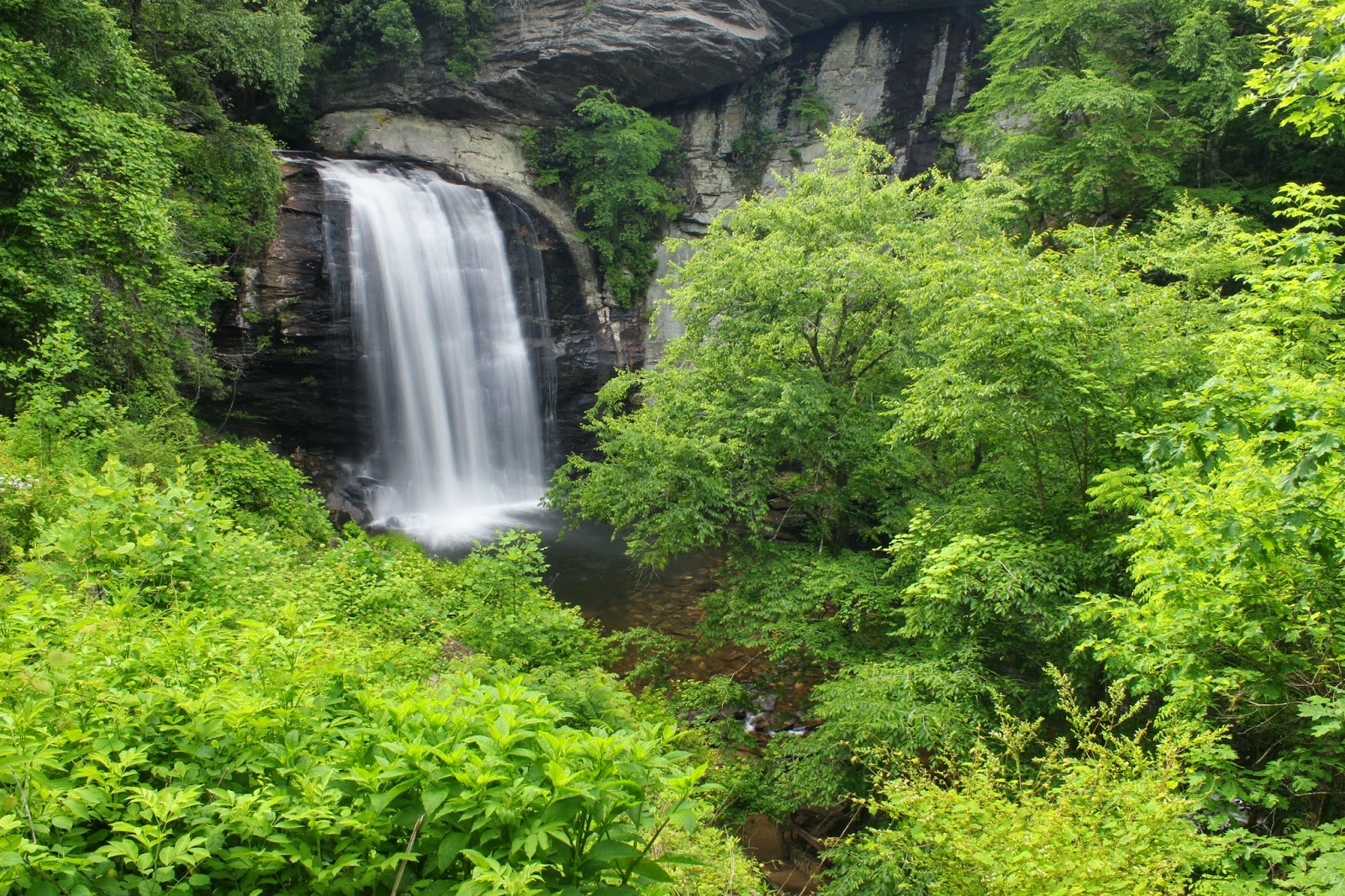
Looking Glass Falls may be the most photographed waterfall in North Carolina. It's not only beautiful but the most accessible by being right beside of the main road. The park service has done a commendable job keeping it clean and maintaining a slight resemblance of a natural setting if you are able to hike downstream of the sidewalks a little. Jeff had sent me an image of his mother standing near the road with the waterfall as a back drop and we were able to line it up and almost recreate it with him in the same location. Larry was a blur the whole time we were at Looking Glass. He was near the base, downstream, over logs, on the sidewalks...you get the idea, he was loving it! As much fun as we were having I rounded them up and got us back on the road to Moore Cove Falls.

The Moore Cove hike is a little longer than our first few stops and gave us a good leg stretch as it winds uphill into the valley where the waterfall is hidden. Since my first visit to Moore Cove, the park service had installed several wooden bridges and when we arrived at the base there was a large observation deck constructed. The fancy woodwork did little to contain us and Larry was once again on the loose. He walked behind the 50ft waterfall and ducked his head under it's flow gasping with approval. I scurried up the bank to the right of the falls and took some shots in the weeds eliminating the man made trails and decks in my shot. Jeff seemed to really like the waterfall and also ducked his head under it, so as I hiked down the bank I took my turn under mother nature's shower.
Jeff behind Moore Cove Falls.
Moore Cove Falls.

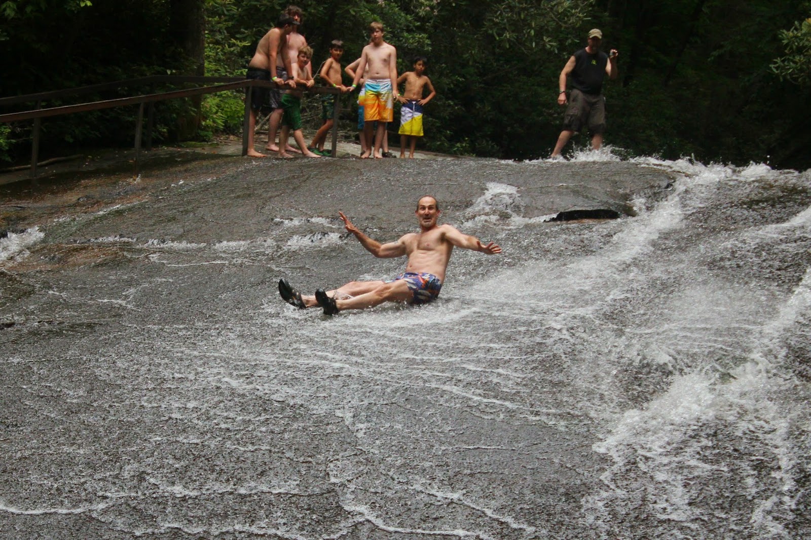
I'm not sure if Sliding Rock counts as a waterfall but it's a long cascade and is one of the most popular stops in the mountains of North Carolina. Due to it's popularity it's also a fee area, but we were elated to see the collection area closed with a sign stating "Free Admission Day" Jeff and Larry both were eager to hit the water slide but were slowed by closed bathrooms and having to change "on the fly" I can only imagine how much therapy bills would be for the person who would stumble upon that scene. I arrived at the observation deck above the cascade and was happy to see less than five people riding down. I had brought my new GoPro with me and gave Jeff a quick tutorial on how to use it so he could video his ride down Sliding Rock, another trip that was 40 years later for him. Larry was the first to take the slide and his enthusiasm was clear as his smile was wider than any of the children playing in the water. He crashed in sideways and Jeff was a right behind him with the camera rolling as he splashed down. Both of them were quick to make it back to the top of the rock and Larry took over the camera for the second trip down but accidentally turned it off so his video was ruined. After a couple of trips on Sliding Rock and many laughs later, we got back to the car and took turns watching for approaching vehicles so that Larry and Jeff could get dressed in dry clothes and were off to Log Hollow for more hiking.
Larry's face says it all. Sliding Rock.
Log Hollow Falls.
Northern Tributary of Log Hollow Branch.

A few weeks ago I had been in the area we were hiking and went to Log Hollow Falls for the first time and was impressed with the three waterfalls there. Jeff, Larry, and I hiked the old logging road around the ridge skipping the first waterfall to arrive at the main attraction first and then took in the furthermost of the waterfalls before stopping at the first waterfall which is the most difficult one to reach. All three falls are beautiful but Jeff and Larry seemed to be most impressed by the low flow 100ft Northern Tributary of Log Hollow Branch. Sometimes I feel like a difficult hike makes a person appreciate a waterfall even more and this was a perfect example. When we arrived back at the car we had finished the highway 276 portion of our hike and had already seen eight waterfalls!

TO BE CONTINUED....

Wednesday, April 30, 2014

I can't say enough good things about the Clark's Creek area of Erwin, Tennessee. To me it's the waterfall mecca of Northeast Tennessee with a wide variety of waterfalls and trails from beginner family friendly hikes such as Sill Branch Falls to one of the most difficult hikes in the entire state, Buckeye Falls.

This afternoon I had completed all my house chores and was finally feeling better after spending over a week with a head cold. I wanted to get out in the woods for a while and Clark's Creek was calling my name. A few weeks ago I visited Delsatch Falls off of the Buckeye Falls Trail and fell in love with it. Delsatch is over 85ft high and located on Chigger Branch that flows into Clark's Creek. Despite it's height, it receives very few visitors or attention, which is quite frankly, baffling. The trail begins at the dead end circular parking area on Clark's Creek Road. There is a immediate creek crossing that is a fairly good indicator of what kind of flow to expect at the falls, if you don't have to get your feet wet, I would suggest hiking elsewhere. The past few days it's rained hard and for most of the day. I was anticipating swollen muddy creek conditions but found it to be calm and maybe slightly above normal levels. I did have to wade the creek at the crossing so I trudged on up the wide road that serves as a horse trail trying to stay quite in hopes of seeing one of the many bears that call Clark's Creek home. The warm temperatures have really helped with the woods greening up and all types of wildflowers lined the trail. I noticed the trilliums were starting to wilt, another bothersome development, considering they're one of my favorites.
Trail heading up Chigger Branch.
Plants along the trail.

In all, there are seven creek crossings before you need to start watching for a small faint path that will turn left and cross Clark's Creek at the mouth of Chigger Branch. It's not marked so just pay attention to the lay of the land you will see the large valley of Chigger Branch as you approach the spur trail. Once across Clark's Creek you will see a path on the left of the branch. I was surprised at how easy the trail was to follow but was informed that another group of hikers had cleared it a while back thinking they were blazing the way to Buckeye Falls. In reality, Buckeye Falls is much further up Clarks' Creek and far more difficult to access. The trail although easy to follow isn't worn and you get the feeling of being one of the first people up that valley. There's no sign of trash or graffiti and the hike is level as it stays with the creek. I took my time and soaked in the beauty of it all stopping to take pictures of flowers and cascades along the way. I can't recall hiking on a trail that has as many grapevines as Delsatch does, sometimes you have to pick your way over and under them as they hug the trail for a small stretch. As the trail begins gently rising I was pleased to see that most of the Trillium was still at full peak and as I stopped to photograph one I saw a tiny spider hiding in the bloom. Sometimes I wonder of what I miss on some of the hikes I have rushed through.
Spider posing on a Trillium bloom.
Chigger Branch.
Delsatch Falls.
A short distance up the waterfall and the rock is super slick!

As I mentioned earlier, the trail is faint but clear, sometimes it's easier just to wade up the creek and picking the best route for you. The creek will take you directly to the base of the waterfall so there's no way to get lost. When closing in on the waterfall the creek kind of spreads out and one fork of it is dry and easy to hike in. A cool breeze starts coming from ahead and through the trees you can see the upper portion of the cascading waterfall. I climbed around a large rock and fallen log and found a flat spot to set my tripod on. There's a lot of dead fall piled up here but today I spent some time moving it to the bank below the falls. Some people would suggest against tampering with the scene but I feel there's no harm in removing something that is already dead. Once I finished I was really pleased with my efforts, a small pool was now visible and enhanced the waterfall *in my opinion* Large white bloom Trillium line both sides of the waterfall and I climbed around to take pictures of some of the larger ones. A huge tree has fell about halfway down the waterfall into some of the cascade but it doesn't distract from the falls too bad in it's current resting place. I climbed up to just below it to look down the falls, it certainly isn't a spot you would want to fall. It would be a long slide and a painful landing! As I was finishing up the clouds parted and the sun came out, making my hike out a little warmer but just as pleasant. Enjoy the pictures and get out and enjoy the woods, and as always, happy trails!
Dwarf Iris.

Monday, April 7, 2014

 Regardless if it's lesser known or overlooked, Squibb Creek Falls should be near the top of everyone's hiking to do list. The waterfall is at the end of a 2.5 mile trail in the Sampson Mountain Wilderness, whose claim to fame is having the second highest bear population next to the Smoky Mountains. I have always wanted to encounter a bear with proper spacing and time to draw a camera's focus for a dream shot but so far they have eluded me with the exception of the one I met crawling on my knees through a laurel tangle at Pine Ridge Falls. My only regret from that day was the fact I was wearing my favorite underwear... so with the knowledge of the possibility of a bear and a waterfall I haven't seen I made the call to one of my favorite hiking partners for the trip to Horse Creek Park near Greeneville, Tennessee.
What's that?
He just needed to get comfortable so I could take his picture.

Jeff Forrester and I first met at one of my many tours of duty in the grocery business in Kingsport, Tennessee. I was told he was an avid hiker and had traveled the country as he had worked for other retail businesses. Jeff and I, or Old Man Winter as I named him, quickly became friends and although we've had many calamity befall us on our trips, his wife still allows him to tromp through the woods with me at every opportunity.
This was taken around 8pm as daylight faded.

We arrived at the end of Horse Creek Road near the picnic area and all access jeep road with plenty of sunshine and the warmest weather we've had this year. It was the first time this year I've been able to wear a t-shirt and shorts on a hike and it felt more like a midsummer day instead of early April. Having the benefit of daylight savings time, we had plenty of daylight despite arriving after 5pm. I glanced at my directions and we took the dirt road that follows the creek away from the noise of the family picnics and trout fishers to the isolation of the valley ahead. Even the breeze was warm and Jeff and I tore through the first mile with ease. We came upon a campsite and the intersection of several ATV roads and I didn't remember from my directions. Upon closer inspection, we had hiked over a mile the wrong way! Near where we parked, we passed a wooden bridge across the creek and the correct way to Squibb Creek Falls. Suddenly, we were at a disadvantage of time and daylight and we stretched our pace to make up for my error.
Day two and one of my favorite shots from the hike.
Snail on a mossy log.
Had to zoom on this cascade, the pool is really deep!

When we finally made the foot bridge we had hiked over two miles and still have 2.5 miles to go to arrive at the waterfall and it was after 6pm...two hours before dark. Despite the mistake, we had high spirits. We weren't wearing neck ties or answering mind numbing questions, we were in nature. Wild flowers were popping up everywhere lining the trail and the rhododendron tunnels shaded us from the afternoon sun. A short distance past the Sampson Wilderness sign we crossed two nice wooden bridges just before arriving at a nice A frame cabin next to the creek. A small patch of private property is crossed at the cabin before joining national forest land just after the first rock hop crossing of the creek. The trail stays with Squibb Creek and there are many cascades and photo ops along the way, but with daylight fading, I kept my camera packed and hustled further up the mountain.
Of course the sun would come out!
Remains of a old bridge.

Our quick pace got to Jeff's legs first and we stopped occasionally to let him get his breath. I had managed to read that it was over 1100ft in elevation gain from start to finish and it was becoming obvious that the number wasn't exaggerated. Several long uphill grades were negotiated with heavy breathing and burning legs but at each leveling of the trail we were treated with another beautiful cascade. Out of the corner of my eye I thought I saw a squirrel running through the woods to our left, but it turned out to be a raccoon! I immediately dug into my camera bag for a quick lens change to get a zoom on him as he scurried up a tree. He picked a fork in the tree to come to a rest and it set me up perfectly to get a good picture. Time was the furthest thing from my mind and when I finally looked over for Jeff I noticed he was gone, continuing to hike on without me. I put away my gear and entered a slight jog to catch up with him near a downed tree. The tree was the perfect height to piss you off. It was too low to comfortably crawl under but too high to get a leg over the top. I was able to get my leg over and pushed my weight down enough to lower it for Jeff to cross with me. As we wound into the upper valley of Squibb creek the banks of the creek grew steeper and a cool breeze was in our face as we labored on, and I knew we had to be getting close to the waterfall. A sharp switchback lifts the trail around a slide area and as I rounded a bend Squibb Creek Falls came into view.
Another wonderful cascade.
Slightly different angle on the same cascade.
Squibb Creek Falls.
From the left side of the falls. Helps illustrate the height.

I felt the rush of seeing a new waterfall for the first time and was at the base of the falls a good five minutes ahead of Jeff. The waterfall is 25ft high as it is pinched between boulders before fanning out bouncing off a large boulder near it's base. The height is deceptive because of the way the falls twists near the base and the vantage point of looking at it straight on. Although the banks are steep on either side I climbed up on the left side of the waterfall and found a good angle as the sun faded behind the mountains. I knew we didn't have much time left so I hurriedly shot and tried to squeeze in as many angles as possible. Jeff didn't bring his camera but took out his cellphone for a few pictures anyway. As bad as it pained me, we had to get moving or we would be in the bear filled woods at dark with no flashlights.
Spring.
Squibb Creek is unreal.
Last one from Squibb Creek Trail.

The hike out was mostly downhill and at each beautiful cascade I passed I kicked myself for not reading the directions more carefully to start with. As we made the last bridge crossing before the main road it was completely dark, our eyes had adjusted to it enough for us to make it back to the parking area and the safety of the truck. A few days later I once again had some free time and a day to spend in the woods, and I came back to snag all the pictures I didn't get to on my first visit. Before I even realized it, I had spent 6 hours on the trail and completely drained my camera battery. As I stated earlier, Squibb Creek is as good a hike that you can take in Northeast Tennessee. Hopefully the pictures I took over two different hikes will do it justice. Until next time, happy trails!


Saturday, March 29, 2014

Driving in traffic is perhaps one of my greatest stresses. I often marvel at the level of stupidity of the people I share the road with and often arrive at my destination with a red face and what I'm sure is unsafe blood pressure levels. For instance, while commuting to a meeting I became trapped behind three cars who felt the need to drive side by side by side driving 10 miles under the speed limit. It's in these times the full appreciation of the outdoors and the isolation they provide are most evident to me.
Trail closed? Yeah right!
The trail as it enters the rock slide area.
Deep pool on Stony Creek.

One of my personal favorites for such seclusion is found in Dungannon, Virginia. Hanging Rock Recreation Area is seldom used but has beauty at every turn. The park has no doubt seen better days but it also serves as a trail head for several nice hikes including the Falls of Little Stony. I consider hiking in from the rec area the "back way" because during the summer you can drive to a short distance above the upper falls and see all the waterfalls in less than a miles hike, but I also prefer the longer route because of the numerous cascades, cliffs, and overall beauty along the 5.2 mile journey.
Cascade at the first footbridge.
Dad heading up the trail.
Awesome cascades.

My dad has become quite the hiker himself, shedding over 100lbs since last April and really being determined to get his life and health in order. I've been amazed at the transformation and blessed because now he can tag along with me without being exhausted. A few weeks ago we headed into the mountains of Virginia for hike up to the falls on one of the warmer days we've had this winter.
Creek side at the cascades.
The tree waterfall.

The trail is in great shape and remains level as it follows Little Stony Creek up the valley. A short distance into the hike is a large rock shelf that has collapsed some time ago and the massive boulders are stuck in the ground like daggers. One of the boulders has split once it hit the ground and the trail snakes narrowly between the rocks. At around half a mile the first footbridge crosses the creek and a large cascade. The trail enters a flat stretch along the left side of the creek with a large rock that stretches for over 100 yards level with the water. I love this area and always stop to take photos from different perspectives. I told dad to hike on and I would catch up with him up the trail. After getting my fill of photos I sprinted up the trail looking for dad, and was surprised at how far he had hiked in a short distance. It wasn't long before we arrived at the second foot bridge which crosses the creek at a side stream waterfall that empties into the gorge.

As the trail gained elevation I noticed large icicles formed along the gorge walls and soon snow started to line the trail. Dad and I took our time and he waited patiently as I would stop to drop the tripod for each shot. I found a nice cascade that was about a twenty foot drop below us and was able to slide down the bank and keep my feet under me impressing him that someone my size was so nimble. A tree has fell over the creek creating a perfect waterfall spanning it's length and by the size of the tree, it will be there for years to come.
Clear skies.
Snow starting to line the trail.

We made good timing and the gorge transformed before our eyes with the cliffs rising steeper and the snow getting deeper. The trail passes under a cliff were icicles hang dangerously above your head. I had to take advantage of such a unique photo op although I wasn't about to make a sound and cause them to come crashing down on me. The trail winds up the mountain away from the creek to avoid some slide damage and eventually drops back down to creek level just short of the third and final footbridge before reaching the waterfalls. On the ridge high above us Bear Rock loomed over the valley and we crossed the longest of the bridges and a short time later we were at the largest of the waterfalls on Little Stony at the observation deck the forest service has constructed. Of course, I wanted to be at the base of the falls and left dad to take a break and headed down the steep bank. I went off trail to get further downstream to include some cascades in my shots. In my haste, I lost my footing and caught my arm in a small tree causing it to get jerked painfully above my head. I wiggled free but my arm hung completely numb at my side! I tried lifting it and it wouldn't budge and used my right arm to pick it up but still nothing. I rubbed my hand over the other one for what seemed like an eternity before my fingers began to tingle and the feeling came back in my arm. Dad had missed it and I was glad as I took photos of the roaring falls. I told him about it once I reached the observation deck and he surmised it could have been a slight nerve strain or rotator cuff issue. He had me do a couple of throwing motions and stretch it over my head before determining I was a wimp and that we should move along.
The longest bridge on the trail.
Death from above.
Lower falls on Little Stony.
From the observation deck.

A short distance upstream from the lower waterfalls is the smallest waterfall on Little Stony. It's hidden off trail in a rocky cove and I didn't take time to scramble down this time. Maybe a couple of tenths of a mile upstream is the upper falls and one of the nicer falls in Virginia. It isn't very high but free falls into a large pool and can be photographed on all sides INCLUDING behind it! I could tell dad was proud we had reached our destination and was even more excited that he still felt great. I told him that he was just tuning up for our father/son hike to Mt LeConte this coming summer.
Sun peeking over Upper Stony Falls.
Dad and I.
One last look at Little Stony.

If you ever find yourself feeling the stresses of life maybe a trip to Dungannon, Virginia and Little Stony Falls will brighten your day. Hiking always helps me unwind but it also helps me focus on how blessed I am. No matter your situation there is always someone who has it worse than you. Until next time, happy trails!